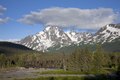
Paradise Peak (Kenai Mountains)

Last updated
Paradise Peak
Paradise Peak.jpg
Northwest aspect
Highest point
Elevation 6,050 ft (1,844 m) [1] [2]
Prominence 1,100 ft (335 m) [2]
Parent peak Hearth Mountain (6,182 ft) [3] [2]
Isolation 2.54 mi (4.09 km) [2]
Coordinates 60°16′00″N149°11′34″W / 60.2667352°N 149.1927039°W / 60.2667352; -149.1927039 [4]
Geography
Relief map of USA Alaska.png
Red triangle with thick white border.svg
Paradise Peak
Location of Paradise Peak in Alaska
CountryUnited States
State Alaska
Borough Kenai Peninsula
Protected area Chugach National Forest [3]
Parent range Kenai Mountains [3]
Topo map USGS Seward B-6
Climbing
First ascent 1969 Grace Hoeman [5]

Paradise Peak is a 6,050-foot-elevation (1,844-meter) mountain summit in Alaska, United States.

Contents

Description

Paradise Peak is located 14 miles (23 km) northeast of Seward in the Kenai Mountains, on land managed by Chugach National Forest. [3] Precipitation runoff and glacial meltwater from the mountain's slopes drains to Kenai Lake via the Snow River. Although modest in elevation, topographic relief is significant as the summit rises over 4,800 feet (1,463 m) above Paradise Valley in 1.5 miles (2.4 km). The mountain is named in association with Paradise Valley which it borders, and the toponym was officially adopted in 1971 by the United States Board on Geographic Names. [4] The first ascent of the summit was made on June 29, 1969, by Grace Hoeman via the West Ridge. [6] [7]

Climate

Based on the Köppen climate classification, Paradise Peak is located in a tundra climate zone with long, cold, snowy winters, and mild summers. [8] Weather systems coming off the Gulf of Alaska are forced upwards by the Kenai Mountains (orographic lift), causing heavy precipitation in the form of rainfall and snowfall. Winter temperatures can drop below 0 °F with wind chill factors below −10 °F. This climate supports several glaciers on the peak's slopes, two of which are unofficially named Fireside Glacier and Hearth Glacier.

See also

Related Research Articles

<span class="mw-page-title-main">Mount Alice (Alaska)</span> Mountain summit in Alaska, US

Mount Alice is a 5,318-foot (1,621 m) mountain summit in the U.S. state of Alaska.

<span class="mw-page-title-main">Mount Abbe</span> Mountain in Alaska, United States

Mount Abbe is an 8200+ feet double summit mountain located in the Fairweather Range of the Saint Elias Mountains, in southeast Alaska. The peak is situated near the terminus of the Johns Hopkins Glacier, within Glacier Bay National Park and Preserve, 100 mi (161 km) northwest of Juneau, and 8.2 mi (13 km) northeast of Mount Orville. Although modest in elevation, relief is significant since the mountain rises up from tidewater in less than two miles. Mount Abbe is often seen and photographed with the Johns Hopkins Glacier, which is a popular destination for cruise ships. The mountain was named in 1936 by William Osgood Field and William Skinner Cooper, of the American Geographical Society, for Cleveland Abbe Jr., (1872-1934), an American geographer. Abbe received a Ph.D. in 1898 from Johns Hopkins University. The Gilman Glacier and Clark Glacier on the mountain's slopes were named for Daniel Coit Gilman, the institution's first president, and William Bullock Clark who was a professor of geology at the university. The mountain's name was officially adopted in 1937 by the United States Geological Survey. The first ascent of the south summit was made June 11, 1977, by Jim Wickwire and Dusan Jagersky via the Southeast Face. Three days later, Dusan Jagersky was killed while descending an unnamed peak. The first ascent of the north summit was made July 14, 1991, by Walter Gove and William Pilling. The months May through June offer the most favorable weather for climbing Mount Abbe, but it's a challenging climb in any conditions, with few attempts.

<span class="mw-page-title-main">Mount Ascension</span> Mountain in the state of Alaska

Mount Ascension is a prominent 5,710-foot (1,740 m) mountain summit located in the Kenai Mountains, on the Kenai Peninsula, in the U.S. state of Alaska. The mountain is situated in Chugach National Forest, 6.8 mi (11 km) south of Mount Adair, 3.5 mi (6 km) north of Resurrection Peaks, and 10 mi (16 km) north of Seward, Alaska. The peak is near the mouth of Resurrection River into Resurrection Bay. The name Resurrection, referring to the Resurrection of Jesus, is overused for nearby landforms on the Kenai peninsula, as the mountain to the immediate south is Resurrection Peaks. This Ascension name is a variation of the theme. Mount Ascension's name was proposed in 1968 by the Mountaineering Club of Alaska, and officially adopted in 1969 by the United States Geological Survey. Access to the peak is via the Lost Lake Trail, and mountaineering skills are needed to reach the summit. In clear weather the immense Harding Icefield can be seen from the top. The first ascent of this peak was made October 6, 1968, by John Vincent Hoeman and his wife, Dr. Grace (Jansen) Hoeman.

<span class="mw-page-title-main">Andy Simons Mountain</span> Double summit mountain in Alaska, United States

Andy Simons Mountain is a prominent 6,407-foot (1,953 m) double summit mountain located in the Kenai Mountains, and the fourth-highest peak on the Kenai Peninsula in the state of Alaska. The true summit is 1.3 mile west of the 5,300+ foot subsidiary east peak on this five-mile-long northwest-to-southeast trending mountain. The mountain is situated in Chugach National Forest, 7.2 mi (12 km) east of Mount Adair, and 17 mi (27 km) north of Seward, Alaska. The Seward Highway and Alaska Railroad traverse its western foot. Precipitation runoff from the mountain drains into Kenai Lake.

<span class="mw-page-title-main">Amulet Peak</span> Mountain in Alaska, USA

Amulet Peak is a prominent 8,290-foot (2,527 m) elevation mountain summit located 39 mi (63 km) east-northeast of Palmer, in the northern Chugach Mountains of the U.S. state of Alaska. This landmark of the Matanuska Valley is set midway between Anchorage and Glennallen, at mile 94 of the Glenn Highway. It is situated 12 mi (19 km) west of Matanuska Glacier, and 3.7 mi (6 km) northeast of Awesome Peak, its nearest higher neighbor. Established climbing routes on this peak include the east and south ridges, as well as the north face which is the most difficult and dangerous. The first ascent of this peak was made in 1968 by John Vincent Hoeman, his wife Grace Hoeman, and William Babcock, via the south ridge.

<span class="mw-page-title-main">Benign Peak</span> Mountain in Alaska, U.S.

Benign Peak is a 7,235 ft (2,210 m) elevation mountain summit located in the western Chugach Mountains, in Anchorage Municipality in the U.S. state of Alaska. The mountain is situated in Chugach State Park, 28 mi (45 km) east of Anchorage, and 4.5 mi (7 km) south of Eklutna Lake. The nearest higher peak is Mount Rumble, 2.2 mi (4 km) to the southwest, and The Mitre is set 2.4 mi (4 km) east-southeast, on the opposite side of the Eklutna Glacier. Although modest in elevation, relief is significant since the eastern aspect of the mountain rises over 5,000 feet above this glacier in approximately one mile. This peak belongs to a group of peaks in the Eklutna River drainage which start with the letter "B", such as Bold Peak, Bashful Peak, Baleful Peak, and Mt. Beelzebub. Benign Peak was so named in 1965 by the Mountaineering Club of Alaska because "nearby Bellicose Peak was a much harder climb, while this one's nature was quite benign since the rock was not too rotten and the weather wasn't too bad." Benign Peak's name was officially adopted in 1966 by the U.S. Board on Geographic Names. The first ascent of this mountain was made in August 1965 by Art Davidson and John Vincent Hoeman by ascending the East Face, and descending the South Gully.

<span class="mw-page-title-main">Rook Mountain</span> Mountain summit in Alaska, United States.

Rook Mountain is a 6,685-foot-elevation (2,038-meter) mountain summit in Alaska, United States.

<span class="mw-page-title-main">Mount Yukla</span>

Mount Yukla is a 7,569-foot (2,307 m) mountain summit in Alaska, United States.

<span class="mw-page-title-main">Santa Ana Peak</span>

Santa Ana Peak is a 4,764-foot-elevation (1,452-meter) mountain summit in Alaska, United States.

<span class="mw-page-title-main">Mount Eva</span> Mountain in Alaska, U.S.

Mount Eva is a 5,019-foot-elevation (1,530-meter) mountain summit in Alaska, United States.

<span class="mw-page-title-main">Tiehacker Mountain</span>

Tiehacker Mountain is a 4,435-foot-elevation (1,352-meter) mountain summit in Alaska, United States.

<span class="mw-page-title-main">Mount Burkett</span>

Mount Burkett is a 9,730-foot-elevation (2,966-meter) mountain summit in Alaska, United States.

<span class="mw-page-title-main">The Rowel</span>

The Rowel is a 9,806-foot-elevation (2,989-meter) mountain summit in Alaska.

<span class="mw-page-title-main">Mount Chichantna</span> Mountain summit in Alaska

Mount Chichantna is a 10,893-foot-elevation (3,320-meter) mountain summit in Alaska.

<span class="mw-page-title-main">Hearth Mountain</span>

Hearth Mountain is a 6,182-foot-elevation (1,884-meter) mountain summit in Alaska, United States.

<span class="mw-page-title-main">Haydon Peak</span>

Haydon Peak is an 11,924-foot-elevation (3,634-meter) mountain summit in Alaska, United States.

<span class="mw-page-title-main">Finland Peak</span>

Finland Peak is a 9,405-foot (2,867 m) elevation mountain summit in the U.S. state of Alaska.

<span class="mw-page-title-main">Alabaster Peak</span>

Alabaster Peak is an 8,065-foot-elevation (2,458-meter) mountain summit located 35 miles (56 km) east of Palmer, in the northern Chugach Mountains of Alaska. This peak of the Matanuska Valley is set midway between Anchorage and Glennallen, and can be seen from the Glenn Highway. It is situated 15 miles (24 km) west of Matanuska Glacier and 1.8 miles (2.9 km) south of Awesome Peak. Precipitation runoff from the mountain drains into Coal, Monument, and Gravel creeks, which are tributaries of the Matanuska River. Topographic relief is significant as the summit rises 3,065 feet along the west slope in one mile (1.6 km). The first ascent of the summit was made on July 4, 1970, by Robert Spurr, Bob Pelz, and Royce Purinton via the Spectrum Glacier and North Ridge. This mountain's toponym has not been officially adopted by the United States Board on Geographic Names, so it is only marked as "8065" on USGS maps.

<span class="mw-page-title-main">Peril Peak (Alaska)</span> Mountain in Alaska

Peril Peak is a 7,040-foot (2,146 m) mountain summit in Alaska, United States.

<span class="mw-page-title-main">Mount Bagot</span>

Mount Bagot is a 2,181-metre (7,156-foot) mountain summit located on, and in part defining, the international border between British Columbia, Canada, and Alaska, United States.

References

  1. United States Board on Geographic Names, Decisions on Geographic Names in the United States, Decision List No. 7101, (1971), page 1.
  2. 1 2 3 4 "Paradise Peak - 6,050' AK". listsofjohn.com. Retrieved 2024-01-20.
  3. 1 2 3 4 "Paradise Peak, Alaska". Peakbagger.com. Retrieved 2024-01-20.
  4. 1 2 "Paradise Peak". Geographic Names Information System . United States Geological Survey, United States Department of the Interior . Retrieved 2024-01-20.
  5. Rodman Wilson (1972). "Grace Hoeman, M.D., 1921–1971". American Alpine Journal. Retrieved 2024-01-20.
  6. Grace Hoeman (1970). "North America, United States, Alaska, Paradise Peak, Kenai Peninsula". American Alpine Journal. Retrieved 2024-01-20.
  7. World Climbing: Based on Mountain Magazine, Dark Peak, 1980, ISBN   9780950627236, p. 46.
  8. Peel, M. C.; Finlayson, B. L.; McMahon, T. A. (2007). "Updated world map of the Köppen−Geiger climate classification". Hydrol. Earth Syst. Sci. 11 (5): 1633. Bibcode:2007HESS...11.1633P. doi: 10.5194/hess-11-1633-2007 . ISSN   1027-5606.