
The railway from Paris-Est to Mulhouse-Ville is a 491-kilometre long railway line, that connects Paris to Mulhouse via Troyes, Chaumont and Belfort, France. The railway was opened in several stages between 1848 and 1858. [2]
The railway from Paris-Est to Mulhouse-Ville is a 491-kilometre long railway line, that connects Paris to Mulhouse via Troyes, Chaumont and Belfort, France. The railway was opened in several stages between 1848 and 1858. [2]
The Paris–Mulhouse railway leaves the Gare de l'Est in Paris in eastern direction. At Noisy-le-Sec, where the Paris–Strasbourg railway branches off, it turns south. It crosses the river Marne at Nogent-sur-Marne, and turns southeast. Near Gouaix it reaches the river Seine, and follows this river upstream, until Nogent-sur-Seine on its right bank, then on its left bank, roughly southeastward. At Troyes it crosses the Seine again, and turns east.
It enters the Aube valley near Jessains, and continues upstream along Bar-sur-Aube. It leaves the Aube and enters the upper Marne valley at Chaumont. It passes Langres and the railway junction Culmont-Chalindrey, where it crosses the line Nancy–Dijon. It reaches the river Saône at Jussey, and follows it downstream until Port-sur-Saône, where it turns southeast to reach Vesoul. It turns east, passing Lure, Belfort, Dannemarie and Altkirch. Here it turns northeast and enters its terminus Mulhouse.
The main stations on the Paris–Mulhouse railway are:
The construction and exploitation of a railway from Paris to Mulhouse was conceded to the newly formed Chemins de fer de l'Est in 1853. [3] The first section that was opened in 1848 led from Flamboin-Gouaix to Troyes, and was part of a railway from Montereau-Fault-Yonne to Troyes. The section from Paris to Noisy-le-Sec was opened in 1849, as a part of the Paris–Strasbourg railway. In 1856 a line from Noisy-le-Sec to Nogent-sur-Marne was built. The sections between Nogent-sur-Marne and Flamboin-Gouaix, between Troyes and Langres, and between Dannemarie and Mulhouse were opened in 1857. Finally in 1858 the section between Langres and Dannemarie was opened. [2]
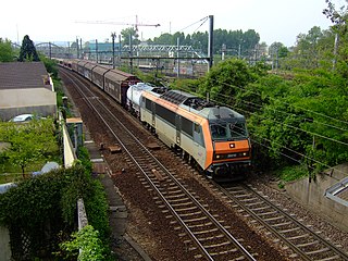
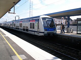
The Paris–Mulhouse railway is used by the following passenger services:

The Gare de Lyon, officially Paris Gare de Lyon, is one of the seven large mainline railway stations in Paris, France. It handles about 148.1 million passengers annually according to the estimates of the SNCF in 2018, with SNCF railways and the RER D accounting for around 110 million and the RER A accounting for 38 million, making it the second-busiest station of France after the Gare du Nord and one of the busiest in Europe.

The Gare de l'Est, officially Paris Est, is one of the seven large mainline railway station termini in Paris, France. It is located in the 10th arrondissement, not far southeast from the Gare du Nord, facing the Boulevard de Strasbourg, part of the north–south axis of Paris created by Georges-Eugène Haussmann.

The Compagnie des chemins de fer de l'Est, often referred to simply as the Est company, was an early French railway company. The company was formed in 1853 by the merger of Compagnie du chemin de fer de Paris à Strasbourg, operating the Paris-Strasbourg line, and Compagnie du chemin de fer de Montereau à Troyes. In 1938 it became part of the majority state-owned Société Nationale des Chemins de fer Français (SNCF).
The Gare de la Bastille was a railway station on the Place de la Bastille in the 12th arrondissement of Paris, France. The station was opened in 1859 and served as the terminus of the 55-kilometre (34 mi)-long line to Vincennes and Verneuil-l'Étang. The line was opened only to serve the Fort de Vincennes; it was extended to La Varenne and later to Brie-Comte-Robert. The line finally reached Verneuil-l'Étang in 1892 and connected to the line to Mulhouse. Part of the line was included into the new suburban commuter rail line RER A on 14 December 1969. The station was demolished in 1984 so that the Opéra Bastille could be built.

État 140-101 to 140-370 is a class of 2-8-0 steam locomotive of the Chemins de fer de l'État, and subsequently the Société Nationale des Chemins de fer Français (SNCF).

The A5 Autoroute, which was constructed in 1990 to relieve the A6, links the Parisian region with the Langres area. It is a 238 km toll road under the management of the Autoroutes Paris-Rhin-Rhône (APRR). It makes up parts of the European routes E54, E511, and E17. Before the A5 was completed, the section linking Troyes with Langres was known as the A26. This route crosses the departments of Seine-et-Marne, Yonne, Aube and Haute-Marne.

The Route nationale 19 (N19) is a trunk road (nationale) in north east France. The road forms part of European route E54.
The Grande Ceinture line is a railway line around Paris, located 15 kilometres (9.3 mi) from the Boulevard Périphérique. The decision to build it was taken at the end of the 19th century, to connect the radial lines linking the capital to the provinces and provide relief to the busy Petite Ceinture Line.

Épinay - Villetaneuse is a railway station located in the commune of Épinay-sur-Seine, Seine-Saint-Denis department, France. It is also adjacent to the communes of Montmagny and Deuil-la-Barre in Val d'Oise.

The Paris–Le Havre railway is an important 228-kilometre long railway line, that connects Paris to the northwestern port city Le Havre via Rouen. Among the first railway lines in France, the section from Paris to Rouen opened on 9 May 1843, followed by the section from Rouen to Le Havre that opened on 22 March 1847.

The railway from Paris to Marseille is an 862-kilometre long railway line, that connects Paris to the southern port city of Marseille, France, via Dijon and Lyon. The railway was opened in several stages between 1847 and 1856, when the final section through Lyon was opened. The opening of the LGV Sud-Est high speed line from Paris to Lyon in 1981, the LGV Rhône-Alpes in 1992 and the LGV Méditerranée in 2001 has decreased its importance for passenger traffic.

The railway from Paris to Bordeaux is an important French 584-kilometre long railway line, that connects Paris to the southwestern port city Bordeaux via Orléans and Tours. The railway was opened in several stages between 1840 and 1853, when the section from Poitiers to Angoulême was finished. The opening of the LGV Atlantique high speed line from Paris to Tours in 1989 has decreased the importance of this section of the line for passenger traffic; the opening of the LGV Sud Europe Atlantique in 2017 has seen all long distance passenger trains migrating to that line and leaving space for more regional and local trains, as well as freight trains.

The railway from Paris-Est to Strasbourg-Ville is a 493-kilometre-long railway line that connects Paris to Strasbourg via Châlons-en-Champagne and Nancy, France. Officially, the line does not start at the Gare de l'Est in Paris: the first 9 km until Noisy-le-Sec is shared with the railway from Paris to Mulhouse. The railway was opened in several stages between 1849 and 1852. The opening of the LGV Est high speed line from Paris to Baudrecourt in Lorraine in 2007 has decreased the importance of the section Paris–Sarrebourg for passenger traffic.
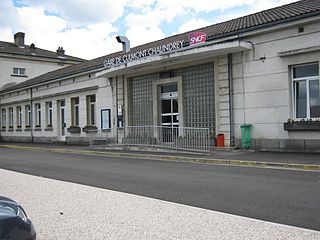
Gare de Culmont-Chalindrey is a railway station serving the small towns Culmont and Chalindrey, Haute-Marne department, eastern France. It is an important railway junction, situated on the Paris–Mulhouse railway, the Is-sur-Tille–Culmont-Chalindrey railway and the Culmont-Chalindrey–Toul railway.

Saverne station is a French railway station located on the Noisy-le-Sec–Strasbourg railway. It is located within the commune of Saverne, in departement Bas-Rhin, in northeastern France.

Émerainville–Pontault-Combault is a French railway station on the Paris-Est–Mulhouse-Ville railway, located in Émerainville, Seine-et-Marne department, Île-de-France region. It bears the name of Pontault-Combault as its territory reaches the south and the west of the building. It serves a district of Marne-la-Vallée.

Gretz-Armainvilliers is a French railway station located in Gretz-Armainvilliers, in the Seine-et-Marne department, in the Île-de-France region.

Ozoir-la-Ferrière is a French railway station in Ozoir-la-Ferrière, in the Seine-et-Marne department in the Île-de-France region. It is served by RER E.
Roissy-en-Brie is a French railway station in Roissy-en-Brie, in the Seine-et-Marne department in the Île-de-France region. It is served by RER E.