The Sydney Harbour Bridge is an Australian heritage-listed steel through arch bridge across Sydney Harbour that carries rail, vehicular, bicycle, and pedestrian traffic between the Sydney central business district (CBD) and the North Shore. The view of the bridge, the harbour, and the nearby Sydney Opera House is widely regarded as an iconic image of Sydney, and of Australia itself. The bridge is nicknamed "The Coathanger" because of its arch-based design.

Port Jackson, consisting of the waters of Sydney Harbour, Middle Harbour, North Harbour and the Lane Cove and Parramatta Rivers, is the ria or natural harbour of Sydney, Australia. The harbour is an inlet of the Tasman Sea. It is the location of the Sydney Opera House and Sydney Harbour Bridge. The location of the first European settlement and colony on the Australian mainland, Port Jackson has continued to play a key role in the history and development of Sydney.

Sydney Cove is a bay on the southern shore of Sydney Harbour, one of several harbours in Port Jackson, on the coast of Sydney, New South Wales. Sydney Cove is a focal point for community celebrations, due to its central Sydney location between the Sydney Opera House and the Sydney Harbour Bridge. It is also one of the main congregation points for Sydney New Year's Eve.

The Rocks is an urban locality, tourist precinct and historic area of Sydney's city centre, in the state of New South Wales, Australia. It is located on the southern shore of Sydney Harbour, immediately north-west of the Sydney central business district.

The North Shore is a region of Sydney, New South Wales, Australia, a subset of the Northern Sydney region. The region is customary, not legal or administrative, and in customary usage generally includes the suburbs located on the northern side of Sydney Harbour up to Hornsby, and between Middle Harbour and the Lane Cove River.

Wynyard railway station is a heritage-listed underground commuter rail station located in the north-west precinct of the Sydney central business district, in New South Wales, Australia. The station opened on 28 February 1932 to coincide with the opening of the Sydney Harbour Bridge.

North Sydney is a suburb and major commercial district on the Lower North Shore of Sydney, Australia. North Sydney is located 3 kilometres north of the Sydney central business district and is the administrative centre for the local government area of North Sydney Council.

Milsons Point railway station is a heritage-listed railway station located on the North Shore line, serving the Sydney suburb of Milsons Point in New South Wales, Australia. It is served by Sydney Trains T1 North Shore line services. The station is located above ground, accessible via a stairs and a lift, in Milsons Point, in the North Sydney Council local government area of New South Wales, Australia. It was designed and built by the Sydney Harbour Bridge Branch of the NSW Department of Public Works. The property was added to the New South Wales State Heritage Register on 2 April 1999.

George Street is a street in the Sydney central business district of Australia.

Milsons Point is a suburb on the lower North Shore of Sydney, in the state of New South Wales, Australia. The suburb is located 3 kilometres north of the Sydney central business district in the local government area of North Sydney Council.
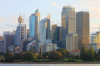
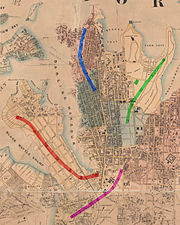
The Sydney Central Business District (CBD) is the historical and main commercial centre of Sydney. The Sydney CBD is Sydney's city centre, or Sydney City, and the two terms are used interchangeably. The CBD or city centre is often referred to simply as "Town" or "the City". The Sydney city centre extends southwards for about 3 km (2 mi) from Sydney Cove, the point of first European settlement in which the Sydney region was initially established. Due to its pivotal role in Australia's early history, it is one of the oldest established areas in the country.

Dawes Point is a suburb of the City of Sydney, in the state of New South Wales, Australia. Dawes Point is located on the north-western edge of the Sydney central business district, at the southern end of Sydney Harbour Bridge, adjacent to The Rocks. At times Dawes Point has been considered to be part of The Rocks, or known as West Rocks, part of Millers Point, or part of it known as Walsh Bay.

Barangaroo is an area of central Sydney, New South Wales, Australia. It is located on the north-western edge of the Sydney central business district and the southern end of the Sydney Harbour Bridge. It is part of the local government area of the City of Sydney; it was part of the territory of the Cadigal people, the traditional owners of the Sydney city region. The area was used for fishing and hunting by Indigenous Australians prior to colonial settlement. The area is inclusive of The Hungry Mile, the name harbourside workers gave to the docklands area of Darling Harbour East during The Great Depression, where workers would walk from wharf to wharf in search of a job, often failing to find one.

St James Parish, Cumberland is one of the 57 parishes of Cumberland County, New South Wales, a cadastral unit for use on land titles. It is one of the four small parishes in the Sydney city area, which is named after the Anglican church of St James, which was consecrated in 1824. The name St James is also used today for the railway station in the same area.
St Andrew Parish, Cumberland is one of the 57 parishes of Cumberland County, New South Wales, a cadastral unit for use on land titles. It is one of the four small parishes in the Sydney city area, and is named after the church of St Andrew's. The parish was named while the church was still in the planning stages. The parish includes Pyrmont and the Darling Harbour area. It is bounded by Wattle Street in the south west, George Street in the south and east, and King Street in the north-east. It includes Town Hall railway station, which is on the eastern end of the parish.

The Dawes Point Battery remains is a heritage-listed former artillery fortification and now visitor attraction located adjacent to the southern pylon of the Sydney Harbour Bridge at Hickson Road in inner city Sydney, on the boundary between Dawes Point and The Rocks in the City of Sydney local government area of New South Wales, Australia. It was built and modified from 1791 to 1925 by Lieutenant William Dawes, Robert Ross, Francis Greenway, and George Barney. The property is owned by Property NSW, an agency of the Government of New South Wales. It was added to the New South Wales State Heritage Register on 10 May 2002.

The Darling Mills Creek, an urban watercourse that is part of the Parramatta River catchment, is located in Greater Western Sydney, New South Wales, Australia.
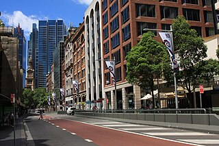
York Street is a street in the Sydney central business district in New South Wales, Australia. York Street runs 1.050 kilometres (0.652 mi) in a north to south direction only and is used predominantly by buses from the northern districts of Sydney.

The Argyle Cut is a heritage-listed roadway and road cutting located at Argyle Street in the inner-city Sydney suburb of The Rocks in the City of Sydney local government area of New South Wales, Australia. It was built from 1843 to 1868 with convict and paid labour. The property is owned by the Sydney Harbour Foreshore Authority, an agency of the Government of New South Wales. It was added to the New South Wales State Heritage Register on 10 May 2002.

The Millers Point & Dawes Point Village Precinct is a heritage-listed retail shops that support harbour functions, office and urban residences located at Upper Fort Street, in the inner city Sydney suburb of Millers Point and Dawes Point in the City of Sydney local government area of New South Wales, Australia. It was built from 1788 to. It is also known as Millers Point, Goodye, Leightons Point, Jack the Millers Point, 'Dawes Point, Tar-ra, Parish St Philip, Flagstaff Hill, Cockle Bay Point, the Point and Fort Street. It was added to the New South Wales State Heritage Register on 28 November 2003. The precinct was formerly home to industrial buildings and urban residences.