The geology of the Grand Teton area consists of some of the oldest rocks and one of the youngest mountain ranges in North America. The Teton Range, partly located in Grand Teton National Park, started to grow some 9 million years ago. An older feature, Jackson Hole, is a basin that sits aside the range.

The Moenkopi Formation is a geological formation that is spread across the U.S. states of New Mexico, northern Arizona, Nevada, southeastern California, eastern Utah and western Colorado. This unit is considered to be a group in Arizona. Part of the Colorado Plateau and Basin and Range, this red sandstone was laid down in the Lower Triassic and possibly part of the Middle Triassic, around 240 million years ago.

The Kaibab Limestone is a resistant cliff-forming, Permian geologic formation that crops out across the U.S. states of northern Arizona, southern Utah, east central Nevada and southeast California. It is also known as the Kaibab Formation in Arizona, Nevada, and Utah. The Kaibab Limestone forms the rim of the Grand Canyon. In the Big Maria Mountains, California, the Kaibab Limestone is highly metamorphosed and known as the Kaibab Marble.

The Chugwater Formation is a mapped bedrock unit consisting primarily of red sandstone, in the states of Wyoming, Montana, and Colorado in the United States. It is recognized as a geologic formation in Colorado and Montana, but as a Group, the Chugwater Group, in Wyoming. Despite its presence below the highly studied Morrison Formation, the Chugwater receives little attention.

Hindeodus is an extinct genus of conodonts in the family Anchignathodontidae. The generic name Hindeodus is a tribute to George Jennings Hinde, a British geologist and paleontologist from the 1800s and early 1900s. The suffix -odus typically describes the animal's teeth, essentially making Hindeodus mean Hinde-teeth.

The Ecca Group is the second of the main subdivisions of the Karoo Supergroup of geological strata in southern Africa. It mainly follows conformably after the Dwyka Group in some sections, but in some localities overlying unconformably over much older basement rocks. It underlies the Beaufort Group in all known outcrops and exposures. Based on stratigraphic position, lithostratigraphic correlation, palynological analyses, and other means of geological dating, the Ecca Group ranges between Early to earliest Middle Permian in age.

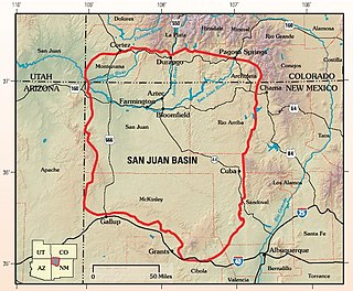
The San Juan Basin is a geologic structural basin located near the Four Corners region of the Southwestern United States. The basin covers 7,500 square miles and resides in northwestern New Mexico, southwestern Colorado, and parts of Utah and Arizona. Specifically, the basin occupies space in the San Juan, Rio Arriba, Sandoval, and McKinley counties in New Mexico, and La Plata and Archuleta counties in Colorado. The basin extends roughly 100 miles (160 km) N-S and 90 miles (140 km) E-W.

The Ishbel Group is a stratigraphic unit of Permian age in the Western Canadian Sedimentary Basin. It is present in the Canadian Rockies of Alberta and British Columbia. First defined by A. McGugan in 1963, it is named for Mount Ishbel of the Sawback Range in Banff National Park, and parts of the group were first described in the vicinity of the mountain at Ranger Canyon and Johnston Canyon.

The Phosphoria Formation of the western United States is a geological formation of Early Permian age. It represents some 15 million years of sedimentation, reaches a thickness of 420 metres (1,380 ft) and covers an area of 350,000 square kilometres (140,000 sq mi).

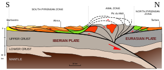
The Pyrenees are a 430-kilometre-long, roughly east–west striking, intracontinental mountain chain that divide France, Spain, and Andorra. The belt has an extended, polycyclic geological evolution dating back to the Precambrian. The chain's present configuration is due to the collision between the microcontinent Iberia and the southwestern promontory of the European Plate. The two continents were approaching each other since the onset of the Upper Cretaceous (Albian/Cenomanian) about 100 million years ago and were consequently colliding during the Paleogene (Eocene/Oligocene) 55 to 25 million years ago. After its uplift, the chain experienced intense erosion and isostatic readjustments. A cross-section through the chain shows an asymmetric flower-like structure with steeper dips on the French side. The Pyrenees are not solely the result of compressional forces, but also show an important sinistral shearing.
The Zonguldak basin of northwestern Turkey is the only basin in Turkey with mineable coal deposits. It has been mined for coal since the late 1800s. The basin takes its name after Zonguldak, Turkey, and lies at approximately 41° N. It is roughly elliptical in shape with its long axis oriented roughly southwest to northeast, and is adjacent to the Black Sea. Three main regions have been recognized in the Zonguldak basin: from west to east, Armutcuk, Zonguldak, and Amasra.

The Dinwoody Formation is a geologic formation in the western United States. It preserves fossils dating back to the Triassic period.
The Coyote Butte Limestone (OR085) is a geologic formation in Oregon. It preserves fossils dating back to the Sakmarian to Kungurian stages of the Permian period, spanning an estimated 23 million years. The formation occurs in isolated buttes to the north; Triangulation Hill, and south; type locality and name giver Coyote Butte and Tuckers Butte, on either side of the Grindstone and Twelvemile Creeks in Crook County, Oregon.
In 2015, 27.6 million metric tons of marketable phosphate rock, or phosphorite, was mined in the United States, making the US the world's third-largest producer, after China and Morocco. The phosphate mining industry employed 2,200 people. The value of phosphate rock mined was US$2.2 billion.
One of the major depositional strata in the Himalaya is the Lesser Himalayan Strata from the Paleozoic to Mesozoic eras. It had a quite different marine succession during the Paleozoic, as most parts of it are sparsely fossiliferous or even devoid of any well-defined fossils. Moreover, it consists of many varied lithofacies, making correlation work more difficult. This article describes the major formations of the Paleozoic – Mesozoic Lesser Himalayan Strata, including the Tal Formation, Gondwana Strata, Singtali Formation and Subathu Formation.

The Organ Rock Formation or Organ Rock Shale is a formation within the late Pennsylvanian to early Permian Cutler Group and is deposited across southeastern Utah, northwestern New Mexico, and northeastern Arizona. This formation notably outcrops around Canyonlands National Park, Natural Bridges National Monument, and Monument Valley of northeast Arizona, southern Utah. The age of the Organ Rock is constrained to the latter half of the Cisuralian epoch by age dates from overlying and underlying formations. Important early terrestrial vertebrate fossils have been recovered from this formation in northern Arizona, southern Utah, and northern New Mexico. These include the iconic Permian terrestrial fauna: Seymouria, Diadectes, Ophiacodon, and Dimetrodon. The fossil assemblage present suggests arid environmental conditions. This is corroborated with paleoclimate data indicative of global drying throughout the early Permian.

The geology of Utah, in the western United States, includes rocks formed at the edge of the proto-North American continent during the Precambrian. A shallow marine sedimentary environment covered the region for much of the Paleozoic and Mesozoic, followed by dryland conditions, volcanism, and the formation of the basin and range terrain in the Cenozoic.

The geology of Uzbekistan consists of two microcontinents and the remnants of oceanic crust, which fused together into a tectonically complex but resource rich land mass during the Paleozoic, before becoming draped in thick, primarily marine sedimentary units.
The geology of Lithuania consists of ancient Proterozoic basement rock overlain by thick sequences of Paleozoic, Mesozoic and Cenozoic marine sedimentary rocks, with some oil reserves, abundant limestone, dolomite, phosphorite and glauconite. Lithuania is a country in the Baltic region of northern-eastern Europe.

The Greater Green River Basin (GGRB) is a 21,000 square mile basin located in Southwestern Wyoming. The Basin was formed during the Cretaceous period sourced by underlying Permian and Cretaceous deposits. The GGRB is host to many anticlines created during the Laramide Orogeny trapping many of its hydrocarbon resources. It is bounded by the Rawlins Uplift, Uinta Mountains, Sevier overthrust belt, Sierra Madre Mountains, and the Wind River Mountain Range. The Greater Green River Basin is subdivided into four smaller basins, the Green River Basin, Great Divide Basin, Washakie Basin, and Sand Wash Basin. Each of these possesses hydrocarbons that have been economically exploited. There are 303 named fields throughout the basin, the majority of which produce natural gas; the largest of these gas fields is the Jonah Field.


