Pattersonville-Rotterdam Junction, New York

Last updated
Pattersonville-Rotterdam Junction
USA New York location map.svg
Red pog.svg
Pattersonville-Rotterdam Junction
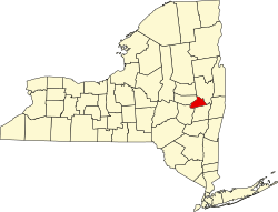
Location within the state of New York
Usa edcp location map.svg
Red pog.svg
Pattersonville-Rotterdam Junction
Pattersonville-Rotterdam Junction (the United States)
Coordinates: 42°52′44″N74°3′32″W / 42.87889°N 74.05889°W / 42.87889; -74.05889
Country United States
State New York
County Schenectady
Area
  Total1.5 sq mi (3.9 km2)
  Land1.4 sq mi (3.5 km2)
  Water0.2 sq mi (0.4 km2)
Population
 (2000)
  Total918
  Density680.0/sq mi (262.5/km2)
Time zone UTC-5 (Eastern (EST))
  Summer (DST) UTC-4 (EDT)
FIPS code 36-56764

Pattersonville-Rotterdam Junction was a census-designated place (CDP) in Schenectady County, New York, United States. The population was 918 at the 2000 census. The area was not delineated as a CDP for the 2010 census.

Contents

The CDP was in the town of Rotterdam and took its name from two hamlets in the town.

Geography

The Pattersonville-Rotterdam Junction CDP was located at 42°52′44″N74°3′32″W / 42.87889°N 74.05889°W / 42.87889; -74.05889 (42.878941, -74.058756). [1]

According to the United States Census Bureau, the CDP had a total area of 1.5 square miles (3.9 km2), of which 1.4 square miles (3.5 km2) was land and 0.2 square miles (0.4 km2), or 10.60%, was water.

Demographics

As of the census [2] of 2000, there were 918 people, 368 households, and 260 families residing in the CDP. The population density was 680.0 inhabitants per square mile (262.5/km2). There were 381 housing units at an average density of 282.2 per square mile (109.0/km2). The racial makeup of the CDP was 98.47% White, 0.33% African American, 0.44% Native American, 0.33% Asian, and 0.44% from two or more races. Hispanic or Latino of any race were 1.31% of the population.

There were 368 households, out of which 29.3% had children under the age of 18 living with them, 56.3% were married couples living together, 12.0% had a female householder with no husband present, and 29.3% were non-families. 23.1% of all households were made up of individuals, and 8.4% had someone living alone who was 65 years of age or older. The average household size was 2.49 and the average family size was 2.95.

In the CDP, the population was spread out, with 22.0% under the age of 18, 8.5% from 18 to 24, 26.7% from 25 to 44, 25.8% from 45 to 64, and 17.0% who were 65 years of age or older. The median age was 41 years. For every 100 females, there were 95.7 males. For every 100 females age 18 and over, there were 90.4 males.

The median income for a household in the CDP was $42,857, and the median income for a family was $55,547. Males had a median income of $29,000 versus $25,750 for females. The per capita income for the CDP was $19,039. None of the families and 3.6% of the population were living below the poverty line, including no under eighteens and 12.0% of those over 64.

Historic site

Rotterdam Junction is the site of the Mabee House which, dating to the 17th century, is the oldest house in the Mohawk Valley. The house is part of the Mabee Farm Historic Site, owned and operated by the Schenectady County Historical Society. [3] [4]

Related Research Articles

<span class="mw-page-title-main">Ford City, California</span> Census-designated place in California, United States

Ford City is a census-designated place (CDP) in Kern County, California, United States. Ford City is located 1 mile (1.61 km) north of Taft, at an elevation of 892 feet (272 m). The population was 4,348 at the 2020 census, up from 4,278 at the 2010 census. It is immediately north of Taft, between the huge Midway-Sunset Oil Field to the southwest, and the almost exhausted Buena Vista Oil Field to the northeast. State Route 119 passes east of town from its junction with SR 33 to the south.

<span class="mw-page-title-main">Brownville, New Jersey</span> Populated place in Middlesex County, New Jersey, US

Brownville is an unincorporated community and census-designated place (CDP) located within Old Bridge Township, in Middlesex County, in the U.S. state of New Jersey. As of the 2010 United States Census, the CDP's population was 2,383.

<span class="mw-page-title-main">Twin Lakes, New Mexico</span> CDP in New Mexico, United States

Twin Lakes is a census-designated place (CDP) in McKinley County, New Mexico, United States. The population was 1,069 at the 2000 census.

<span class="mw-page-title-main">North Boston, New York</span> Census-designated place in New York, United States

North Boston is a hamlet and census-designated place (CDP) in the town of Boston in Erie County, New York, United States. As of the 2010 census, the CDP population was 2,521. It is part of the Buffalo–Niagara Falls Metropolitan Statistical Area.

Tribes Hill is a census-designated place (CDP) located in the Towns of Mohawk (80%) and Amsterdam (20%) in Montgomery County, New York, United States. The population was 1,003 at the 2010 census. One theory is the name is based on this location having been a gathering spot for the Mohawk nation, the dominant Iroquois tribe in the area during colonial times. Tribes Hill spans the border of the Town of Mohawk and Town of Amsterdam, approximately five miles west of the City of Amsterdam on Route 5.

<span class="mw-page-title-main">Mount Ivy, New York</span> Census-designated place in New York, United States

Mount Ivy is a hamlet and census-designated place in the Town of Haverstraw, in Rockland County, New York, United States. It is located north of New City, east of Pomona, south of Thiells, and west of Garnerville. The population was 6,878 at the 2010 census.

<span class="mw-page-title-main">Duane Lake, New York</span> Census-designated place in New York, United States

Duane Lake is a census-designated place (CDP) in Schenectady County, New York, United States. The population was 323 at the 2010 census.

<span class="mw-page-title-main">Mariaville Lake, New York</span> Census-designated place in New York, United States

Mariaville Lake is a census-designated place (CDP) in Schenectady County, New York. The population was 722 at the 2010 census.

<span class="mw-page-title-main">Princetown, New York</span> Town in New York, United States

Princetown is a town in Schenectady County, New York, United States. The population was 2,115 at the 2010 census. It is in the central part of the county, west of the town of Rotterdam.

<span class="mw-page-title-main">South Hill, New York</span> CDP in New York, United States

South Hill is a census-designated place (CDP) in Tompkins County, New York, United States. The population was 7,245 at the 2020 census.

<span class="mw-page-title-main">Berea, South Carolina</span> CDP in South Carolina, United States

Berea is a census-designated place (CDP) in Greenville County, South Carolina, United States. The population was 14,295 at the 2010 census. It is part of the Greenville–Mauldin–Easley Metropolitan Statistical Area.

<span class="mw-page-title-main">West Clarkston-Highland, Washington</span> CDP in Washington, United States

West Clarkston-Highland is a census-designated place (CDP) in Asotin County, Washington, United States. It is part of the Lewiston, ID-WA Metropolitan Statistical Area. The population was 5,488 at the 2020 census.

<span class="mw-page-title-main">Walla Walla East, Washington</span> CDP in Washington, United States

Walla Walla East is a census-designated place (CDP) in Walla Walla County, Washington, United States. The population was 1,672 at the 2010 census.

<span class="mw-page-title-main">Kendall, Washington</span> CDP in Washington, United States

Kendall is a census-designated place (CDP) in Whatcom County, Washington, United States. The population was 191 at the 2010 census.

<span class="mw-page-title-main">Niskayuna (CDP), New York</span> Census-designated place & hamlet in New York, United States

Niskayuna is a hamlet in Schenectady County, New York, United States. The population was 4,859 at the 2010 census.

<span class="mw-page-title-main">Rotterdam (CDP), New York</span> Census-designated place in New York, United States

Rotterdam is a census-designated place (CDP) in the town of Rotterdam in Schenectady County, New York, United States. It is a suburb of Schenectady. The population was 20,652 at the 2010 census.

<span class="mw-page-title-main">Rotterdam, New York</span> Town in New York, United States

Rotterdam is a town in Schenectady County, New York, United States. The population was 30,523 at the 2020 census.

<span class="mw-page-title-main">Esperance, New York</span> Town in New York, United States

Esperance is a town in Schoharie County, New York, United States. The population was 2,043 at the 2000 census. The town was given the name of the principal village, which was named for "hope" in French.

Norfolk is a hamlet in St. Lawrence County, New York, United States. The population was 1,327 at the 2010 census.

<span class="mw-page-title-main">Woodstock (CDP), New York</span> CDP in New York, United States

Woodstock is a hamlet in Ulster County, New York, United States. The population was 2,088 according to the 2010 census. The community of Woodstock is in the eastern part of the Town of Woodstock and is northwest of Kingston. It is located along NY 212 near its junction with NY 375. Although the name of the community and the town lent its name to the Woodstock Festival, that event did not take place in Woodstock.

References

  1. "US Gazetteer files: 2010, 2000, and 1990". United States Census Bureau. 2011-02-12. Retrieved 2011-04-23.
  2. "U.S. Census website". United States Census Bureau . Retrieved 2008-01-31.
  3. "Mabeefarm.org". Archived from the original on 2019-07-17. Retrieved 2022-07-15.
  4. "New York Gun Laws".