
Pawnee County is a county located in the U.S. state of Oklahoma. As of the 2010 census, the population was 16,577. Its county seat is Pawnee. The county is named after the Pawnee Tribe.

The Republican River is a river in the central Great Plains of North America, rising in the High Plains of eastern Colorado and flowing east 453 miles (729 km) through the U.S. states of Nebraska and Kansas.

The Smoky Hill River is a 575-mile (925 km) river in the central Great Plains of North America, running through the U.S. states of Colorado and Kansas.

The Platte River is a major river in the state of Nebraska and is about 310 mi (500 km) long. Measured to its farthest source via its tributary the North Platte River, it flows for over 1,050 miles (1,690 km). The Platte River is a tributary of the Missouri River, which itself is a tributary of the Mississippi River which flows to the Gulf of Mexico. The Platte over most of its length is a muddy, broad, shallow, meandering stream with a swampy bottom and many islands—a braided stream. These characteristics made it too difficult for canoe travel, and it was never used as a major navigation route by European-American trappers or explorers.

The North Platte River is a major tributary of the Platte River and is approximately 716 miles (1,152 km) long, counting its many curves. In a straight line, it travels about 550 miles (890 km), along its course through the U.S. states of Colorado, Wyoming, and Nebraska.
Willow Creek is a tributary of the Colorado River, approximately 35 miles (56 km) long, in north central Colorado in the United States.
Muddy Creek is a tributary of the Colorado River, approximately 60.5 miles (97.4 km) long, in north central Colorado in the United States.

White River is a river, approximately 195 miles (314 km) long, in the U.S. states of Colorado and Utah and is a tributary of the Green River.

Clear Creek is a tributary of the South Platte River, approximately 66 miles (106 km) long, in north central Colorado in the United States. The creek flows through Clear Creek Canyon in the Rocky Mountains directly west of Denver, descending through a long gorge to emerge on the Colorado Eastern Plains where it joins the South Platte. Clear Creek is unusual in that it is a stream named "creek" fed by a stream named "river". Fall River empties into Clear Creek along I-70 west of Idaho Springs, Colorado.

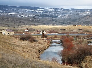
Pawnee National Grassland is a United States National Grassland located in northeastern Colorado on the Colorado Eastern Plains. The grassland is located in the South Platte River basin in remote northern and extreme northeastern Weld County between Greeley and Sterling. It comprises two parcels totaling 193,060 acres (78,130 ha) largely between State Highway 14 and the Wyoming border. The larger eastern parcel lies adjacent to the borders of both Nebraska and Wyoming. It is administered in conjunction with the Arapaho-Roosevelt National Forest from the U.S. Forest Service office in Fort Collins, Colorado, with a local ranger district office in Greeley.

Lodgepole Creek is a tributary of the South Platte River, approximately 278 miles (447 km) long, in the U.S. states of Wyoming, Nebraska and Colorado. Lodgepole Creek drains a basin in the interior of a low plateau which lies between the South Platte Basin and the North Platte Basin in the southeastern corner of Wyoming, the southern edge of the Nebraska Panhandle and several small portions of northeastern Colorado. As its name implies, Lodgepole Creek is a very small stream; for nearly all of its length it flows through the semiarid High Plains. The Lodgepole Creek Valley has been a major transportation route for over 100 years; the line of the original transcontinental railroad, the Lincoln Highway/U.S. Highway 30 and Interstate 80 all run along the stream for much of its length.

Wappinger Creek is a 41.7-mile-long (67.1 km) creek which runs from Thompson Pond to the Hudson River at New Hamburg in Dutchess County, New York, United States. It is the longest creek in Dutchess County, with the largest watershed in the county.

Kanab Creek is one of the many tributaries of the Grand Canyon. It begins in Kane County, Utah, just south of the watershed to the Great Basin and flows 125 miles (201 km) south to the Colorado River. It passes Kanab, Utah, crossing the border to Arizona near Fredonia. It flows through the Kaibab Indian Reservation of the Paiute people and the 1984-designated Kanab Creek Wilderness, a wilderness area, before its mouth in the Grand Canyon National Park.

The Uinta Basin is a physiographic section of the larger Colorado Plateaus province, which in turn is part of the larger Intermontane Plateaus physiographic division. It is also a geologic structural basin in eastern Utah, east of the Wasatch Mountains and south of the Uinta Mountains. The Uinta Basin is fed by creeks and rivers flowing south from the Uinta Mountains. Many of the principal rivers flow into the Duchesne River which feeds the Green River—a tributary of the Colorado River. The Uinta Mountains forms the northern border of the Uinta Basin. They contain the highest point in Utah, Kings Peak, with a summit 13,528 feet above sea level. The climate of the Uinta Basin is semi-arid, with occasionally severe winter cold.
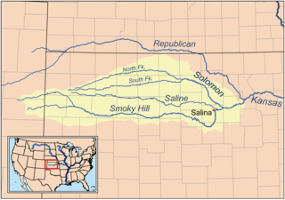
The Solomon River, often referred to as the "Solomon Fork", is a 184-mile-long (296 km) river in the central Great Plains of North America. The entire length of the river lies in the U.S. state of Kansas. It is a tributary of the Smoky Hill River.

The Black River is a 114-mile-long (183 km) river in the White Mountains of the U.S. state of Arizona. It forms southwest of Alpine and flows southwest then northwest to meet the White River west of Fort Apache. The merged streams form the Salt River, a major tributary of the Gila River.

Claverack Creek is a 17.5-mile-long (28.2 km) tributary to Stockport Creek in Columbia County, New York, in the United States. Its source is in the town of Claverack at the hamlet of Mellenville, and its mouth is at its confluence with Kinderhook Creek to form Stockport Creek, in the town of Stockport.
The Pawnee River is a river in southwestern Kansas in the United States, about 198 miles (319 km) long. It is a tributary of the Arkansas River, which in turn is a branch of the Mississippi River.
Vermillion Creek is a 67.5-mile-long (108.6 km) tributary of the Green River. It flows south from Sweetwater County, Wyoming to a confluence with the Green River just north of the Gates of Lodore in Moffat County, Colorado.

Rush Creek is a 102-mile-long (164 km) tributary of Big Sandy Creek in Colorado. It starts at the confluence of South Rush Creek and North Rush Creek in Lincoln County. The creek flows through Cheyenne County before joining Big Sandy Creek in Kiowa County.


