
Alipur is the administrative headquarters and a sub-division of North Delhi district in the state of Delhi, India. It is surrounded by the localities of Bawana, Narela, Budhpur, Bakoli and Mukhmelpur. Alipur comes under the Narela constituency. The nearest metro station is Jahangirpuri Metro Station. Alipur is situated on the Delhi-Amritsar National Highway 1. Sharad Chauhan is the present MLA of Narela constituency. Nisha Mann is the present Nigam Parshad of Alipur.

Anupshahr is a city and a municipal board in Bulandshahr district in the state of Uttar Pradesh, India. It is located on the bank of the holy river Ganga. It is on Bangar alluvial.
Begumpur is a Village is located in Rohini, North West district in the UT of Delhi, India. It is surrounded by different sectors of Rohini i.e. Rohini sec-22, Rohini sec-32, Rohini sec-33, Rohini sec-37 and Rohini sec-38. Begumpur is the village of Yadav's. The village is home to famous Dukhi Ram Samose Wala. This village has very ancient temple namely “Prachin Shiv Mandir”, “ Dada Bhero Mandir” and “ Shri Shyam ji”. There is a very famous temple of “Hanuman Ji” nearby the entrance of the Village. A very big statue of Lord Hanuman can be seen there. Local language of this village is Haryanvi. People are highly supportive. This village has mostly all fascilities like Good Roads, Water supply, electricity is at the Par. Begumpur has a very big Market where anyone can find all the required things.
Bhalswa Jahangir Pur is a census town in North West district in the state of Delhi, India, it is situated next to Bhalswa horseshoe lake.
Chhachhrauli is a tehsil and Gram Panchayat town consisting of 20 wards in Yamuna Nagar district in the state of Haryana, India. It is 11 km north-east of Jagadhari. Chachhraulli is often known as "Cherapunjii of Haryana" as it receives the most rain in the whole of Haryana . It was a municipal committee until 1998. Before independence in 1947, it was the capital of the princely state of Kalsia. The origin of word Chhachhrauli is believed to be "Sat Sherawali" due to a temple located near bus terminus.
Chilla Saroda Bangar is a census town in East Delhi District in the National Capital Territory of Delhi, India.
Dayal Pur is a census town in North East Delhi. It was named after a Gurjar zamindar Ch. Dayal Singh aka "Baba Dayala". Currently majority of native inhabitants range from 6th to 10th generation after Baba Dayala. It was an agricultural village until last three decades when there was an influx of people from Garhwal, Kumaon and 'Purab'.
Jona Pur is a census town in South district in the Indian state of Delhi.
Meham, also spelled Maham, is a small city in Rohtak district of the Indian state of Haryana. It is one of the two sub-divisions in Rohtak district. As a tehsil, it is further divided into two community development blocks, Maham and Lakhan-Majra.
Palavakam is a locality in the south of Chennai and census town in Chennai district in the Indian state of Tamil Nadu. It is located on the East Coast Road about 6 km south of Adyar.
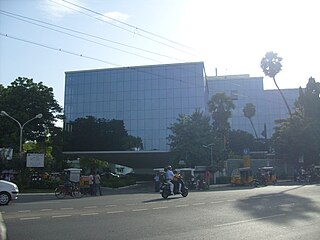
Ramapuram is a neighbourhood in the western part of Chennai, India. It is situated on the Mount-Poonamallee Road at a distance of 3 kilometres from Guindy. Ramapuram forms a part of Maduravoyal taluk, Chennai district.

Rishra is a city and a municipality in Srirampore subdivision of Hooghly district in the Indian state of West Bengal. It is a part of the area covered by Kolkata Metropolitan Development Authority (KMDA).
Sadat Pur extension is a census town in North East district in the Indian state of Delhi.

Sainthia is a city and a municipality in Suri Sadar subdivision of Birbhum district in the Indian state of West Bengal. The city is known as business city of Birbhum district. The city is under the jurisdiction of Sainthia police station. Sainthia is the fourth most populous city in Birbhum district and 95th most populous city in West Bengal. The city covers an area of 10 km2 and had a population of 44,601 in 2011. Located on the banks of Mayurakshi River, Sainthia has been a major settlement. The city is famous for Nandikeshwari Temple, one of the Shakti Peethas in Indian subcontinent.
Siras Pur village is a census town in North West district in the Indian state of Delhi.
Sultan Pur Majra is a census town in North West district in the Indian state of Delhi.

North East Delhi is one of the eleven administrative district of Delhi, India. The district was established in 1997. North East Delhi borders the Yamuna River on the west, Ghaziabad District to the north and east, East Delhi to the south, and North Delhi to the west across the Yamuna. Karawal Nagar, Seelampur and Yamuna Vihar are 3 sub-divisions of this district.
East Delhi is an administrative district of Delhi in India. It is bounded by the Yamuna River on the west, North East Delhi to the north, Ghaziabad District of Uttar Pradesh state to the east, and Gautam Buddha Nagar District of Uttar Pradesh to the south. Administratively, the district is divided into three subdivisions: Gandhi Nagar, Preet Vihar, and Mayur Vihar.
Bidhuna is a big town and a Nagar Panchayat in Auraiya district in the state of Uttar Pradesh, India. Bidhuna has some temples. Durga Devi Mandir is one of the oldest temple in the town. Bidhuna also have known as priest people live in bidhuna and around the town. Kotwali situated near State Bank of India, feeder road. Feeder road as like as Cannaught place of Bidhuna. famous market of Bidhuna Loha Mandi, Sabji Mandi, Gala Mandi, Takiya also most famous place. Most famous shop of cloths Laksmi Sona Saree Centre, Chandan jeans college near State Bank of India. It is also a educational hub for surrounding villages. It has several degree colleges and good quality schools which attract numerous students.
Mubarak Pur Dabas is a village in North West district in the Indian state of Delhi. It is a Jat village in the north-west region of Delhi, dominated by the Dabas gotra.


 India
India 