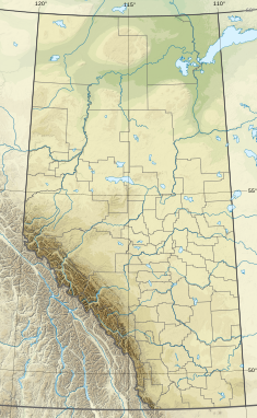
The Athabasca oil sands, also known as the Athabasca tar sands, are large deposits of oil sands rich in bitumen, a heavy and viscous form of petroleum, in northeastern Alberta, Canada. These reserves are one of the largest sources of unconventional oil in the world, making Canada a significant player in the global energy market.

Drayton Valley is a town in central Alberta, Canada. It is located on Highway 22, approximately 133 kilometres (83 mi) southwest of Edmonton. It is surrounded by Brazeau County, known for its vast oil fields. The town is located between the North Saskatchewan River and the Pembina River.

Alberta separatism comprises a series of 20th- and 21st-century movements advocating the secession of the province of Alberta from Canada, either by joining the United States, forming an independent nation or by creating a new union with one or more of Canada's western provinces. The main issues driving separatist sentiment have been the perceived power disparity relative to Ottawa and other provinces, historical grievances with the federal government dating back to the unrealized Province of Buffalo, a sense of distinctiveness with regards to Alberta's unique cultural and political identity, and Canadian fiscal policy, particularly as it pertains to the energy industry.
Redwater is a town in the Edmonton Metropolitan Region of Alberta, Canada that is surrounded by Sturgeon County. It is located on Highway 38, approximately 52 km (32 mi) north of Edmonton. Its population was 2,053 in the 2016 census, while the town's municipal census conducted in 2012 counted a population of 2,116.

Petroleum production in Canada is a major industry which is important to the overall economy of North America. Canada has the third largest oil reserves in the world and is the world's fourth largest oil producer and fourth largest oil exporter. In 2019 it produced an average of 750,000 cubic metres per day (4.7 Mbbl/d) of crude oil and equivalent. Of that amount, 64% was upgraded from unconventional oil sands, and the remainder light crude oil, heavy crude oil and natural-gas condensate. Most of the Canadian petroleum production is exported, approximately 600,000 cubic metres per day (3.8 Mbbl/d) in 2019, with 98% of the exports going to the United States. Canada is by far the largest single source of oil imports to the United States, providing 43% of US crude oil imports in 2015.

The Pembina River is a tributary of the Athabasca River in central Alberta, Canada. "Pembina" is an Indigenous word "Pimbina" (Cree) for the high bush cranberry or summerberry (Viburnum trilobum). The river gives the name to the Pembina oil field, an oil- and gas-producing region centered on Drayton Valley. The environmentalist group Pembina Institute also took its name from the river.
Canada's natural gas liquids industry dates back to the discovery of wet natural gas at Turner Valley, Alberta in 1914. The gas was less important than the natural gasoline - "skunk gas" it was called, because of its distinctive odour - that early producers extracted from it. That natural gas liquid (NGL) could be poured directly into an automobile's fuel tank.
The Canadian petroleum industry arose in parallel with that of the United States. Because of Canada's unique geography, geology, resources and patterns of settlement, however, it developed in different ways. The evolution of the petroleum sector has been a key factor in the history of Canada, and helps illustrate how the country became quite distinct from her neighbour to the south.

Leduc No. 1 was a major crude oil discovery made near Leduc, Alberta, Canada, on February 13, 1947. It provided the geological key to Alberta's most prolific conventional oil reserves and resulted in a boom in petroleum exploration and development across Western Canada. The discovery transformed the Alberta economy; oil and gas supplanted farming as the primary industry and resulted in the province becoming one of the richest in the country. Nationally, the discovery allowed Canada to become self-sufficient within a decade and ultimately a major exporter of oil.

The Cardium Formation is a stratigraphic unit of Late Cretaceous age in the Western Canada Sedimentary Basin. It takes the name from the fossilized heart-shaped cockle shells in the family Cardiidae present. It was first described along the Bow River banks by James Hector in 1895. It is present throughout western Alberta and in northeastern British Columbia, and it is a major source of petroleum and natural gas.
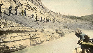
The McMurray Formation is a stratigraphic unit of Early Cretaceous age of the Western Canada Sedimentary Basin in northeastern Alberta. It takes the name from Fort McMurray and was first described from outcrops along the banks of the Athabasca River 5 kilometres (3.1 mi) north of Fort McMurray by F.H. McLearn in 1917. It is a well-studied example of fluvial to estuarine sedimentation, and it is economically important because it hosts most of the vast bitumen resources of the Athabasca Oil Sands region.
Gleniffer Lake also known as Gleniffer Reservoir or originally Lake Gleniffer is an artificial lake in central Alberta, Canada created in 1983 by the construction of the Dickson Dam which impounded the Red Deer River, a major tributary of the South Saskatchewan River which flows into the Saskatchewan River Basin.
Rocky Rapids is a hamlet in central Alberta, Canada within Brazeau County. It is located 1.6 km (0.99 mi) east of Highway 22, approximately 7 km (4.3 mi) north of Drayton Valley.
Alberta Provincial Highway No. 57, commonly referred to as Highway 57, was a highway in central Alberta, Canada that served the Town of Drayton Valley and existed between the 1950s and 1979. It is now part of Highway 22 and Highway 39.
The Winterburn Group is a stratigraphical unit of Frasnian age in the Western Canadian Sedimentary Basin.

Vermilion Energy is an international energy producer based in Calgary, Canada. It has operations in North America, Europe and Australia. Vermilion is listed on the Toronto Stock Exchange and the New York Stock Exchange.
Pembina Pipeline is a Canadian corporation that operates transportation and storage infrastructure delivering oil and natural gas to and from parts of Western Canada. Since 2003, storage has also included ethylene at one location. Western Canada is the source of all products transported by Pembina pipeline systems which include the Syncrude pipeline, Horizon pipeline, and Cheecham oilsands pipelines.

Fracking in Canada was first used in Alberta in 1953 to extract hydrocarbons from the giant Pembina oil field, the biggest conventional oil field in Alberta, which would have produced very little oil without fracturing. Since then, over 170,000 oil and gas wells have been fractured in Western Canada. Fracking is a process that stimulates natural gas or oil in wellbores to flow more easily by subjecting hydrocarbon reservoirs to pressure through the injection of fluids or gas at depth causing the rock to fracture or to widen existing cracks.

This is a brief timeline covering the history of the petroleum industry Alberta and its predecessor states.
The Albertan petroleum industry has had massive, social, economical, political, cultural, and demographic influences on the province of Alberta during the 20th century and 21st century, especially during the second half of the 20th century. Oil and gas replaced Agriculture, and ranching as the primary industry and resulted in the province becoming one of the richest in the country. Nationally, the discovery allowed Canada to become self-sufficient within a decade and ultimately a major exporter of oil. Most of its oil production came from its enormous oil sands deposits, whose production has been steadily rising in recent years. It has produced only 5% of its oil sands, and its remaining oil sands reserves represent 98% of Canada's established oil reserves. The issue of the control of oil has been the main conflict between the provincial government and the federal government, with the issue of oil defining the provincial-federal relationship at every level. The petroleum industry in Alberta has been one of the main factors that have contributed to Western alienation, and Alberta separatism, especially during the 1980s when the federal government under the control of Pierre Trudeau crippled the prospering Albertan economy through the National Energy Program.