Penang Strait

Last updated
Penang Strait
Calflier001 George Town Penang aerial.jpg
George Town on Penang Island (top) and Butterworth on the Malay Peninsula (bottom).
Malaysia relief location map.jpg
Red pog.svg
Penang Strait
Location Penang
Coordinates 5°20′14″N100°21′00″E / 5.3371°N 100.35°E / 5.3371; 100.35
Part of Strait of Malacca
Primary inflows Penang Island:

Seberang Perai:

Basin  countries Malaysia
Max. width3–11.265 km (1.864–7.000 mi)
Islands Aman Island, Gedung Island, Jerejak Island
Settlements Penang Island:

Seberang Perai:

The Penang Strait is an 11 kilometre-wide strait that separates Penang Island from mainland Malay Peninsula. [1] Penang Island is to the west of the channel, while Seberang Perai, the mainland half of the State of Penang, is to the east. The northern and southern ends of the channel join the Strait of Malacca, one of the world's busiest maritime routes.

Contents

The strait provides deepwater passage to the Port of Penang, which is located in Butterworth in Seberang Perai. In addition, Swettenham Pier in George Town, Penang's capital city that is situated on Penang Island, is a popular destination for cruise ships, serving as one of the major entry points into Penang. [2]

Since the foundation of Penang as a trading outpost of the British Empire in 1786, the Penang Strait has historically been a busy shipping route. [3]

Geography

The Penang Strait separates Penang Island from the Malay Peninsula to the east. It connects with the Strait of Malacca to the north and south.

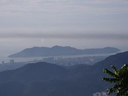
The strait can also be further divided into the North Channel and the South Channel. The North Channel refers to the body of water north of the northeastern promontory of Penang Island, where George Town is situated, whereas the South Channel covers the body of water south of that promontory.

Tributaries

The rivers that flow into the Penang Strait are listed as follows.

Penang Island :

Seberang Perai :

Islands

A handful of islands and islets lie within the South Channel of the Penang Strait. The largest of all is Jerejak Island, located off the southeastern coast of Penang Island. The largely forested island was once the site of a leper asylum, which was then converted into a maximum security prison before its eventual closure in 1993. [4]

Other islets within the strait are Aman Island and Gedung Island, both of which are located off the southern coast of Seberang Perai. Man-made islets were also created during the construction of the Penang Bridge in the 1980s.

History

The Battle of Penang occurred in the Penang Strait on 28 October 1914. This map was produced by the New York Times. When the Emden Raided Penang, Map, fromThe New York Times, Dec.jpg
The Battle of Penang occurred in the Penang Strait on 28 October 1914. This map was produced by the New York Times.

Ever since the establishment of George Town in 1786, the Penang Strait has served as an important shipping route within the State of Penang. Up until the 1970s, the main harbour facilities were situated at Weld Quay in George Town. The reclamation of Weld Quay in the late 19th century allowed larger ships to dock off the city's waterfront, as the depth of the seas off Weld Quay was deeper. [5]

In 1974, the Port of Penang's cargo facilities were shifted to Butterworth across the strait. [3] [6] [7] Thus, cargo and container shipping are mainly handled in Butterworth, while Swettenham Pier in George Town continues to receive cruise ships to this day. [2] [8] In 2015 alone, Swettenham Pier recorded 145 port calls, the highest in Malaysia. [9] Meanwhile, Butterworth's port facilities handled more than 1.2 million TEU of cargo in 2013, making it one of the busiest harbours in the country. [10]

The Penang Strait was also the scene where the initial shots of the Battle of Penang were fired on 28 October 1914. The Imperial German Navy cruiser, SMS Emden, sailed into the strait disguised as a British ship before shelling and torpedoing the Imperial Russian Navy cruiser, Zhemchug. SMS Emden then sailed northwest towards the Malacca Straits, sinking another French warship along the way.

Towards the end of World War II, the Penang Strait was also mined by the Allied forces, using air-dropped mines to impede Japanese merchant shipping. [11]

On 17 January 2010, a dragon boat tragedy occurred when the strong currents resulted in a boat collision, capsizing a dragon boat and killing 6 paddlers on board. The incident raised concerns by several officers, especially Shamsir Mohamed, officer of the Marine Department (northern region) and Lai Chew Hock, chairman of the Penang Dragon Boat Association, regarding the suitability for conducting water sports in the Penang Straits. Shamsir cited busy traffic, unpredictable weather, and strong currents for his concerns, while Chew Hock claimed the area was unsuitable for any water sports activities due to debris from fishing boats and strong currents. [12] However, Lim Choo Hooi, chairman of Penang Forward Sports Club, refuted the claim, saying that neither the wave tides nor the monsoon season posed a problem for training sessions. Coaches would need to check sea and weather conditions prior to conducting training sessions. He also said that the tragedy site was protected from tsunamis and strong waves and had been used for training for three years, making it one of the safest stretches of public shoreline. [13]

Transportation and Infrastructure

Routes across Penang Strait as of 2014 Penang strait crossings.svg
Routes across Penang Strait as of 2014
Cmglee Penang Gedung and Aman Islands aerial.jpg
Aerial view of Gedung Island (left) and Aman Island (right) with Juru and the eastern end of the Penang Second Bridge in the background

Bridges

Two bridges now traverse the Penang Strait - the Penang Bridge and the Second Penang Bridge. The Penang Bridge, completed in 1985, connects Perai on the mainland with the suburb of Gelugor on Penang Island. In 2014, the Second Penang Bridge further south was opened for public use, thereby substituting the Penang Bridge as the longest bridge in Southeast Asia. The Second Penang Bridge runs between Batu Kawan on the mainland and Batu Maung on the island.

To bolster Penang's electricity grid, Tenaga Nasional Berhad (TNB) initiated a RM500 million cross-straits electric grid project in 2022. This significant investment aims to deliver a substantial 2,000 megawatts (MW) of power from the national grid to the island. The project encompasses an 8.5-kilometer-long monopole transmission line, while six of the 31 towers will boast a unique betel nut design, making them a visually striking landmark alongside the iconic Penang Bridge. [14]

Ferry

In addition to the two bridges, Penang ferry service is another transportation link between Penang Island and the mainland (Penang Sentral). Unlike the two bridges, the ferry service operates out of a terminal within the heart of George Town, offering a direct link into the city centre for those entering from the mainland.

Cmglee Penang Strait aerial.jpg
Ferry crossing between the North and South Channels

Related Research Articles

<span class="mw-page-title-main">Penang</span> State in Malaysia

Penang is a Malaysian state located on the northwest coast of Peninsular Malaysia along the Malacca Strait. It has two parts: Penang Island, where the capital city, George Town, is located, and Seberang Perai on the Malay Peninsula. These two halves are physically connected by the Penang Bridge and the Second Penang Bridge. The state shares borders with Kedah to the north and east, and Perak to the south.

<span class="mw-page-title-main">George Town, Penang</span> Capital city of the Malaysian state of Penang

George Town is the capital of the Malaysian state of Penang. It is the core city of the George Town Conurbation, Malaysia's second largest metropolitan area with a population of 2.84 million and the second highest contributor to the country's GDP. The city proper spans an area of 306 km2 (118 sq mi) encompassing Penang Island and surrounding islets, and had a population of 794,313 as of 2020.

<span class="mw-page-title-main">Butterworth, Seberang Perai</span> Town in Malaysia

Butterworth is the city centre of Seberang Perai in the Malaysian state of Penang. It lies about 3 km (1.9 mi) east of George Town, the capital city of Penang, across the Penang Strait. As of 2020, Butterworth had a total population of 80,378 residents.

<span class="mw-page-title-main">Seberang Perai</span> City in the Malaysian state of Penang

Seberang Perai is a city in the Malaysian state of Penang. Located on the Malay Peninsula and separated from Penang Island by the Penang Strait, it shares borders with Kedah to the north and east, and Perak to the south. The city spans an area of 748 km2 (289 sq mi) and had a population of 946,092 as of 2020, making it the third largest city in Malaysia.

<span class="mw-page-title-main">Penang Island</span> Island on west coast of Penang, Malaysia

Penang Island is the main constituent island of the Malaysian state of Penang. It is located off the western coast of Peninsular Malaysia by the Malacca Strait, with the Penang Strait separating the island from Seberang Perai on the mainland. The 295 km2 (114 sq mi) island makes up approximately 28% of Penang's total land mass and is home to about 45% of the state's population as of 2020. The entire island falls under the city of George Town, which also administers the surrounding islets.

<span class="mw-page-title-main">Permatang Pauh</span> Neighbourhood of Seberang Perai in Penang, Malaysia

Permatang Pauh is a residential neighbourhood within the city of Seberang Perai in the Malaysian state of Penang. There are two institutions of higher learning located in Permatang Pauh, namely a campus of Universiti Teknologi MARA (UiTM) and Politeknik Seberang Perai at Bandar Perda.

<span class="mw-page-title-main">Perai</span> Suburb of Seberang Perai in Penang, Malaysia

Perai is a suburb of Seberang Perai in the Malaysian state of Penang. It lies at the southern bank of the Perai River and borders Butterworth to the north.

<span class="mw-page-title-main">Batu Kawan</span> Suburb of Seberang Perai in Penang, Malaysia

Batu Kawan is an island and suburb of Seberang Perai in the Malaysian state of Penang. It is geographically separated from the rest of Seberang Perai by the Jawi and Tengah rivers. As of 2020, Batu Kawan contained a population of 11,409.

<span class="mw-page-title-main">History of Penang</span> History of the Malaysian state of Penang

The State of Penang, one of the most developed and urbanised Malaysian states, is located at the nation's northwest coast along the Malacca Strait. Unlike most Malaysian states, the history of modern Penang was shaped by British colonialism, beginning with the acquisition of Penang Island from the Sultanate of Kedah by the British East India Company in 1786. Developed into a free port, the city state was subsequently governed as part of the Straits Settlements, together with Singapore and Malacca; the state capital, George Town, briefly became the capital of this political entity between 1826 and 1832. By the end of the 19th century, George Town prospered and became one of the major entrepôts in Southeast Asia.

<span class="mw-page-title-main">Transport in Penang</span>

The State of Penang in Malaysia, home to the country's third largest city as well as part of Malaysia's second most populous conurbation, has a relatively well-developed transport infrastructure. The city-state is well-connected by land, air and sea; the Penang International Airport is one of Malaysia's busiest, while the Port of Penang is the main harbour and transshipment hub within northern Malaysia. The North–South Expressway, the main highway along western Peninsular Malaysia, runs through Penang, while the two geographically separate halves of the state are now linked by two bridges and a ferry service.

<span class="mw-page-title-main">North-East District (Penang)</span> District of Malaysia in Penang

The North-East District is a district within the Malaysian state of Penang. The district covers the northeastern half of Penang Island, including the centre of George Town, Penang's capital city. It has an area of 122.79 km2 (47.41 sq mi) and a population of 510,996 as of 2010. The district borders the South-West District to the south-west.

<span class="mw-page-title-main">North Seberang Perai District</span> District of Malaysia in Penang

The North Seberang Perai District is an administrative district on the mainland part of Penang State, Malaysia. It covers an area of 267 square kilometres, and had a population of 286,323 at the 2010 Census. The district is bordered by Muda River in the north which separates Kuala Muda district in Kedah, Kedah state border in the east which separates Kulim district, Perai River in the south which separates Central Seberang Perai and North Channel which separates Penang Island. The district capital is Kepala Batas, and the largest town is Butterworth. Other localities that are located in North Seberang Perai include Penaga, Pinang Tunggal, Bertam, Tasek Gelugor, Teluk Air Tawar and Mak Mandin. It is one of the three administrative districts in the Seberang Perai region, the mainland portion of Penang State. Paddy is largely cultivated in North Seberang Perai as most parts of it is covered by paddy fields.

<span class="mw-page-title-main">South Seberang Perai District</span> District of Malaysia in Penang

The South Seberang Perai District is a district in Penang, Malaysia. It covers an area of 242 square kilometres, and had a population of 184,007 at the 2020 Census. The district is bordered by Junjong River that separates Central Seberang Perai in the north, Kedah state border in the east, Perak state border in the south and the South Channel that separates Penang Island. Rivers that flow through South Seberang Perai are Junjong River, Jawi River and Kerian River. The capital of this district is Sungai Jawi and the largest town is Nibong Tebal. Other towns such as Batu Kawan, Bukit Tambun, Simpang Ampat, Sungai Bakap and Valdor are also located in this district. South Seberang Perai is thriving with the fishing industry and agriculture. Oil palm plantations covers most parts of the area.

<span class="mw-page-title-main">Seberang Perai City Council</span> Local government of the municipality of Seberang Perai in Penang

The Seberang Perai City Council is the city council which administers Seberang Perai, the mainland half of the Malaysian state of Penang. This agency is under the purview of the Penang state government.

<span class="mw-page-title-main">Butterworth railway station</span> Railway station in Butterworth, Malaysia

The Butterworth railway station is a Malaysian railway station located at and named after the town of Butterworth, Penang.

<span class="mw-page-title-main">Malaysian Expressway System</span> System of expressways in Malaysia

The Malaysian Expressway System is a network of national controlled-access expressways in Malaysia that forms the primary backbone network of Malaysian national highways. The network begins with the Tanjung Malim–Slim River tolled road which was opened to traffic on 16 March 1966, later North–South Expressway (NSE), and is being substantially developed. Malaysian expressways are built by private companies under the supervision of the government highway authority, Malaysian Highway Authority.

<span class="mw-page-title-main">Greater Penang Conurbation</span> Metropolitan area in Malaysia

The Greater Penang Conurbation, also known as the George Town Conurbation, is the built-up urban or metropolitan area within and around the Malaysian state of Penang. Encompassing all of Penang, and parts of the neighbouring states of Kedah and Perak, the conurbation was home to over 2.84 million people as of 2020, the second largest in the country after the Klang Valley.

<span class="mw-page-title-main">Port of Penang</span> Port in Malaysia

The Port of Penang is a deepwater seaport within the Malaysian state of Penang. It consists of terminals along the Penang Strait, including five in Seberang Perai and one in George Town. The Port of Penang was the third busiest harbour in Malaysia in terms of cargo as of 2017, handling 1.52 million TEUs of cargo, as well as the busiest port-of-call within the country for cruise shipping.

The Penang Transport Master Plan was drawn up to address the deteriorating traffic conditions in Penang and is projected to cost RM46 billion.

References

  1. Ebook Sailing guide: Strait of Malacca (East). Sea-Seek. 2016.
  2. 1 2 "Is Penang's tourism on the right track?". Penang Monthly. 2015-10-01. Archived from the original on 2016-10-26. Retrieved 2017-02-19.
  3. 1 2 "The Changing Harbour Front". Penang Monthly. 2016-07-01. Archived from the original on 2017-02-20. Retrieved 2017-03-01.
  4. "Jerejak steeped in Malaysia's migrant history, says researcher". Free Malaysia Today. Retrieved 2017-05-16.
  5. "Where the Sea Meets the City is Where the World Meets Penang". Penang Monthly. 2016-07-01. Archived from the original on 2017-02-20. Retrieved 2017-03-01.
  6. "The Mainland Awakens". Penang Monthly. 2016-09-01. Archived from the original on 2017-02-11. Retrieved 2017-03-01.
  7. Natacha Aveline-Dubach, Sue-Ching Jou, Hsin-Huang Michael Hsiao (2014). Globalization and New Intra-Urban Dynamics in Asian Cities. Taiwan: Taiwan Resource Center for Chinese Studies. ISBN   9789863500216.{{cite book}}: CS1 maint: multiple names: authors list (link)
  8. "Penang ready for 17,000 cruise ship passengers". www.thesundaily.my. Retrieved 2017-03-01.
  9. "Penang records country's second-most cruise arrivals last year". 2016-06-07. Retrieved 2017-03-01.
  10. "Container Services". Port of Penang. Archived from the original on 2017-11-07. Retrieved 2017-03-01.
  11. Paul H. Kratoska (1998). The Japanese Occupation of Malaya: A Social and Economic History. C. Hurst & Co. Publishers. pp. 296–. ISBN   978-1-85065-284-7.
  12. "Multiple blunders blamed for dragon boat tragedy". The Star . 2010-01-19. Retrieved 2020-08-07.
  13. "Dragon boat run carried out at students' request, inquest told". The Star . 2010-11-04. Retrieved 2020-08-07.
  14. Dermawan, Audrey (2022-09-15). "TNB's RM500 million project set to boost Penang's economic growth [NSTTV] | New Straits Times". NST Online. Retrieved 2024-02-28.

Literature