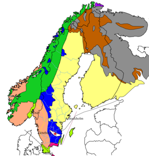
The Baltic Shield is a segment of the Earth's crust belonging to the East European Craton, representing a large part of Fennoscandia, northwestern Russia and the northern Baltic Sea. It is composed mostly of Archean and Proterozoic gneisses and greenstone which have undergone numerous deformations through tectonic activity. It contains the oldest rocks of the European continent with a thickness of 250-300 km.

The Los Angeles Basin is a sedimentary basin located in southern California, in a region known as the Peninsular Ranges. The basin is also connected to an anomalous group of east-west trending chains of mountains collectively known as the Transverse Ranges. The present basin is a coastal lowland area, whose floor is marked by elongate low ridges and groups of hills that is located on the edge of the Pacific Plate. The Los Angeles Basin, along with the Santa Barbara Channel, the Ventura Basin, the San Fernando Valley, and the San Gabriel Basin, lies within the greater southern California region. On the north, northeast, and east, the lowland basin is bound by the Santa Monica Mountains and Puente, Elysian, and Repetto hills. To the southeast, the basin is bordered by the Santa Ana Mountains and the San Joaquin Hills. The western boundary of the basin is marked by the Continental Borderland and is part of the onshore portion. The California borderland is characterized by northwest trending offshore ridges and basins. The Los Angeles Basin is notable for its great structural relief and complexity in relation to its geologic youth and small size for its prolific oil production. Yerkes et al. identify five major stages of the basin's evolution, which began in the Upper Cretaceous and ended in the Pleistocene. This basin can be classified as an irregular pull-apart basin accompanied by rotational tectonics during the post-early Miocene.
The Floridan aquifer system, composed of the Upper and Lower Floridan aquifers, is a sequence of Paleogene carbonate rock which spans an area of about 100,000 square miles (260,000 km2) in the southeastern United States. It underlies the entire state of Florida and parts of Alabama, Georgia, Mississippi, and South Carolina.
The Perth Basin is a thick, elongated sedimentary basin in Western Australia. It lies beneath the Swan Coastal Plain west of the Darling Scarp, representing the western limit of the much older Yilgarn Craton, and extends further west offshore. Cities and towns including Perth, Busselton, Bunbury, Mandurah and Geraldton are built over the Perth Basin.

The Scollard Formation is an Upper Cretaceous to lower Palaeocene stratigraphic unit of the Western Canada Sedimentary Basin in southwestern Alberta. Its deposition spanned the time interval from latest Cretaceous to early Paleocene, and it includes sediments that were deposited before, during, and after the Cretaceous-Paleogene (K-Pg) extinction event. It is significant for its fossil record, and it includes the economically important coal deposits of the Ardley coal zone.

The Dakota is a sedimentary geologic unit name of formation and group rank in Midwestern North America. The Dakota units are generally composed of sandstones, mudstones, clays, and shales deposited in the Mid-Cretaceous opening of the Western Interior Seaway. The usage of the name Dakota for this particular Albian-Cenomanian strata is exceptionally widespread; from British Columbia and Alberta to Montana and Wisconsin to Colorado and Kansas to Utah and Arizona. It is famous for producing massive colorful rock formations in the Rocky Mountains and the Great Plains of the United States, and for preserving both dinosaur footprints and early deciduous tree leaves.

The Geology of Kansas encompasses the geologic history of the US state of Kansas and the present-day rock and soil that is exposed there. Rock that crops out in Kansas was formed during the Phanerozoic eon, which consists of three geologic eras: the Paleozoic, Mesozoic and Cenozoic. Paleozoic rocks at the surface in Kansas are primarily from the Mississippian, Pennsylvanian and Permian periods.
Colorado is a geologic name applied to certain rocks of Cretaceous age in the North America, particularly in the western Great Plains. This name was originally applied to classify a group of specific marine formations of shale and chalk known for their importance in Eastern Colorado. The surface outcrop of this group produces distinctive landforms bordering the Great Plains and it is a significant feature of the subsurface of the Denver Basin and the Western Canadian Sedimentary Basin. These formations record important sequences of the Western Interior Seaway, and as the geology of this seaway was studied, this name came to be used in states beyond Colorado, but was later replaced in several of these states with more localized names.

The Paskapoo Formation is a stratigraphic unit of Middle to Late Paleocene age in the Western Canada Sedimentary Basin. The Paskapoo underlies much of southwestern Alberta, and takes the name from the Blindman River. It was first described from outcrops along that river, near its confluence with the Red Deer River north of the city of Red Deer, by J.B. Tyrrell in 1887. It is important for its freshwater aquifers, its coal resources, and its fossil record, as well as having been the source of sandstone for the construction of fire-resistant buildings in Calgary during the early 1900s.

The Florida Platform is a flat geological feature with the emergent portion forming the Florida peninsula.
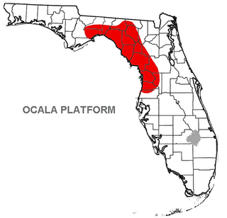
The Ocala Platform or Ocala Uplift is a geologic feature, a structural high, and a northwest-trending uplift paralleling the Peninsular Arch along the west coast.
The Ravenscrag Formation is a stratigraphic unit of early Paleocene age in the Western Canada Sedimentary Basin. It was named for the settlement of Ravenscrag, Saskatchewan, and was first described from outcrops at Ravenscrag Butte near the Frenchman River by N.B. Davis in 1918.

The geology of East Sussex is defined by the Weald–Artois anticline, a 60 kilometres (37 mi) wide and 100 kilometres (62 mi) long fold within which caused the arching up of the chalk into a broad dome within the middle Miocene, which has subsequently been eroded to reveal a lower Cretaceous to Upper Jurassic stratigraphy. East Sussex is best known geologically for the identification of the first dinosaur by Gideon Mantell, near Cuckfield, to the famous hoax of the Piltdown man near Uckfield.

The Juncal Formation is a prominent sedimentary geologic unit of Eocene age found in and north of the Santa Ynez Mountain range in southern and central Santa Barbara County and central Ventura County, California. An enormously thick series of sediments deposited over millions of years in environments ranging from nearshore to deep water, it makes up much of the crest of the Santa Ynez range north of Montecito, as well as portions of the San Rafael Mountains in the interior of the county. Its softer shales weather to saddles and swales, supporting a dense growth of brush, and its sandstones form prominent outcrops.

Lake Monongahela was a proglacial lake in western Pennsylvania, West Virginia, and Ohio. It formed during the Pre-Illinoian ice epoch when the retreat of the ice sheet northwards blocked the drainage of these valleys to the north. The lake formed south of the ice front continued to rise until it was able to breach a low divide near New Martinsville, West Virginia. The overflow was the beginning of the process which created the modern Ohio River valley.
The geology of Nebraska is part of the broader geology of the Great Plains of the central United States. Nebraska's landscape is dominated by surface features, soil and aquifers in loosely compacted sediments, with areas of the state where thick layers of sedimentary rock outcrop. Nebraska's sediments and sedimentary rocks lie atop a basement of crystalline rock known only through drilling.
The geology of Liechtenstein formed at the intersection of the Eastern and Western Alps and the country occupies a wider than average river valley on the Rhine River, running north–south. A spur of the Ratikon Mountains flanks the river to the east, while Schellenberg hill is a defining topographic high in the north.
The geology of Thailand includes deep crystalline metamorphic basement rocks, overlain by extensive sandstone, limestone, turbidites and some volcanic rocks. The region experienced complicated tectonics during the Paleozoic, long-running shallow water conditions and then renewed uplift and erosion in the past several million years ago.
The geology of California is highly complex, with numerous mountain ranges, substantial faulting and tectonic activity, rich natural resources and a history of both ancient and comparatively recent intense geological activity. The area formed as a series of small island arcs, deep-ocean sediments and mafic oceanic crust accreted to the western edge of North America, producing a series of deep basins and high mountain ranges.

The Rub' al Khali Basin or ar-Rubʻ al-Khālī / ar-rubʿ al-ḵālī Basin, Arabic for "Empty Quarter Basin", is a major endorheic sedimentary basin of approximately 560,000 square kilometres (220,000 sq mi) in southern Saudi Arabia, northeastern Yemen, southeastern Oman and southeasternmost United Arab Emirates. The onshore foreland on Mesozoic rift basin is geographically defined by the eponymous Rub' al Khali and covers the regions of Najran and Riyadh and the Eastern Province. The basin is geologically bound by the Central Arabian Arch in the north, the Oman Thrust in the east, the Northern Hadramaut Arch in the south and the Arabian Shield in the west. Politically, the southwestern boundary is formed by the border with Yemen and the border with Oman forms the southeastern boundary.
