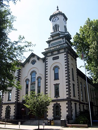
Schuylkill County is a county in the Commonwealth of Pennsylvania. It is located in the heart of Pennsylvania's Coal Region and is part of Northeastern Pennsylvania. As of the 2020 census, the population was 143,049. The county seat is Pottsville.
Northumberland County is a county in the Commonwealth of Pennsylvania. It is part of Northeastern Pennsylvania. As of the 2020 census, the population was 91,647. Its county seat is Sunbury.

Mount Carmel is a borough in Northumberland County, located in the Coal Heritage Region of Central Pennsylvania's Susquehanna River Valley, United States. The population was 5,725 at the 2020 census. It is located 88 miles (141 km) northwest of Philadelphia and 71 miles (114 km) northeast of Harrisburg, in the Coal Region. It is completely encircled by Mount Carmel Township.

Pennsylvania Route 61 is an 81.8-mile-long (131.6 km) state highway that is located in the Commonwealth of Pennsylvania in the United States. The route is signed on a north–south direction, running from U.S. Route 222 Business in Reading northwest to US 11/US 15/PA 147 in Shamokin Dam.

Pennsylvania Route 54 is a state highway which runs for 82 miles (132 km) in eastern Pennsylvania in the United States.
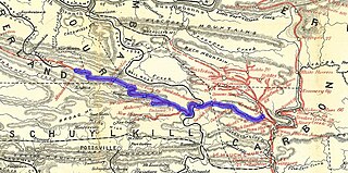
The Lehigh and Mahanoy Railroad, originally the Quakake Railroad, was a rail line connecting Black Creek Junction in the Lehigh Valley region of eastern Pennsylvania with Quakake, Delano, and Mount Carmel. Opened from Black Creek Junction to Quakake in 1858 and to Mount Carmel in 1860, it allowed anthracite coal mined along the line and bridge traffic to be transported east tos New York City. After 1866, it was merged into the Lehigh Valley Railroad and named Mahanoy Branch.
"Mahantongo" is a Lenape word, translated "where we had plenty of meat to eat" or "good hunting grounds." The name is shared by a creek, a valley, and a mountain in central Pennsylvania, and is a common street name in the area. The alternate spelling "Mahantango" is often found in early publications, e.g.,.
Area codes 570 and 272 are telephone area codes in the North American Numbering Plan (NANP) for the northeast quadrant of the U.S. state of Pennsylvania. The numbering plan area (NPA) includes the cities or towns of Scranton, Wilkes-Barre, Williamsport, Stroudsburg, East Stroudsburg, Pittston, Carbondale, Hazleton, Clarks Summit, Towanda, Bloomsburg, Sayre, Tunkhannock, Berwick, Milford, Montrose, Honesdale, Pocono Pines, Nanticoke, Tamaqua, Shavertown, Dallas, Mahanoy City, Sunbury, Jim Thorpe, and as far south as Pottsville and as far west as Lock Haven.

Pennsylvania Route 901 is a 26.4-mile-long (42.5 km) state route located in eastern Pennsylvania. The western terminus of the route is at PA 61 in the Coal Township hamlet of Ranshaw. Its eastern terminus is at PA 183 in Cressona. PA 901 runs northwest-southeast through forested mountains in the Coal Region within Northumberland and Schuylkill counties. The route runs concurrent with PA 54 between Locust Gap and Merrian in Mount Carmel Township before it leaves Northumberland County for Schuylkill County. PA 901 has an interchange with Interstate 81 (I-81) and continues southeast to Minersville. The route runs concurrent with U.S. Route 209 to Pottsville before it splits south and continues to PA 183.

Shamokin Creek is a tributary of the Susquehanna River in Northumberland County, Pennsylvania, in the United States. It is approximately 32.4 miles (52.1 km) long and flows through Mount Carmel, Mount Carmel Township, Coal Township, Shamokin, Ralpho Township, Shamokin Township, Snydertown, Upper Augusta Township, and Sunbury. The watershed of the creek has an area of 137 square miles (350 km2). It experiences significant impacts by abandoned mine drainage and many abandoned mine drainage discharges are in its watershed. Various other impairments also affect parts of the creek's watershed. Shamokin Creek is in the Appalachian Mountains section of the Ridge and Valley physiographic province. Rock formations consisting of sandstone, shale, and anthracite deposits occur in the watershed.
The Lebanon and Tremont Branch of the Philadelphia & Reading Railroad was a railroad line in Lebanon and Schuylkill County, Pennsylvania, built to tap the coal fields in the West End of Schuylkill County and send coal southward to Lebanon.

Pennsylvania Route 125 is a 32.0-mile-long (51.5 km) state highway located in Schuylkill and Northumberland Counties in Pennsylvania. The southern terminus is at PA 443 in Pine Grove. The northern terminus is at PA 61 in Shamokin. The route follows a winding alignment through mountains and valleys in the western part of the Coal Region. PA 125 does not directly access Interstate 81 (I-81); however, north of Pine Grove, there is an interchange with SR 3013 just yards from the highway in Ravine. The route has a concurrency with U.S. Route 209 in Tremont and crosses PA 25 in Hegins. PA 125 was designated in 1928 between PA 25 in Hegins and US 209 in Newtown while the present alignment between Pine Grove and Hegins was a part of PA 25 and the section between Line Mountain and Shamokin was part of PA 225. PA 125 was realigned to its current alignment between PA 443 in Pine Grove and US 122 in Shamokin in the 1930s, with the former section between Hegins and Newtown becoming a realigned PA 25.

Mahanoy Creek is a 51.6-mile-long (83.0 km) tributary of the Susquehanna River in Northumberland and Schuylkill counties, Pennsylvania. There are at least 35 sources of acid mine drainage in the creek's watershed. Anthracite was mined in the upper part of the Mahanoy Creek watershed in the 19th and 20th centuries. Mahanoy Creek's tributaries include Schwaben Creek, Zerbe Run, Little Mahanoy Creek, Shenandoah Creek, and North Mahanoy Creek. Little Mahanoy Creek and Schwaben Creek are two streams in the watershed that are unaffected by acid mine drainage. Schwaben Creek has a higher number and diversity of fish species than the main stem.
The 13th Pennsylvania House of Representatives District is located in southeast Pennsylvania and has been represented by John Lawrence since 2010.
The 17th Pennsylvania House of Representatives District is located in western Pennsylvania and has been represented by Republican Timothy R. Bonner since 2023.
The 116th Pennsylvania House of Representatives District is located in Luzerne County and Schuylkill County and includes the following areas:

The 125th Pennsylvania House of Representatives District is located in Dauphin County and Schuylkill County and includes the following areas:

The 138th Pennsylvania House of Representatives District is located in Southeastern Pennsylvania and has been represented since 2021 by Ann Flood.

North Branch Shamokin Creek is a tributary of Shamokin Creek in Columbia County and Northumberland County, Pennsylvania, United States. It is approximately 4.8 miles (7.7 km) long and flows through Conyngham Township in Columbia County and Mount Carmel Township in Northumberland County. The watershed of the creek has an area of 5.73 square miles (14.8 km2). The entirety of the creek is designated as an impaired waterbody due to metals from abandoned mine drainage. It is acidic, but its pH has been increasing. Underground mine complexes occur within the watershed. The creek has a permeable streambed and experiences flow loss.
Joseph Parker Dando was a member of the Pennsylvania State Senate from 1937 to 1940.