Petilia Policastro

Last updated
Petilia Policastro
Comune di Petilia Policastro
Piazza filottete petilia policastro.jpg
Location of Petilia Policastro
Petilia Policastro
Italy provincial location map 2016.svg
Red pog.svg
Petilia Policastro
Location of Petilia Policastro in Italy
Italy Calabria location map.svg
Red pog.svg
Petilia Policastro
Petilia Policastro (Calabria)
Coordinates: 39°06′50″N16°47′15″E / 39.11389°N 16.78750°E / 39.11389; 16.78750 Coordinates: 39°06′50″N16°47′15″E / 39.11389°N 16.78750°E / 39.11389; 16.78750
Country Italy
Region Calabria
Province Crotone (KR)
Frazioni Foresta
Government
  MayorAmedeo Nicolazzi
Area
[1]
  Total98.35 km2 (37.97 sq mi)
Elevation
436 m (1,430 ft)
Population
 (2018-01-01) [2]
  Total9,073
  Density92/km2 (240/sq mi)
Demonym Petilini
Time zone UTC+1 (CET)
  Summer (DST) UTC+2 (CEST)
Postal code
88837
Patron saint Saint Sebastian
Website Official website

Petilia Policastro is a comune and town in the province of Crotone, in Calabria, Italy.

Contents

History

Petilia Policastro is an ancient village, of presumed Byzantine origin, surrounded in the past by defensive walls. In its territory, along the Tacina and Soleo rivers, remains of settlements of Bruttian origin have been found, dating back to the 4th and 2nd centuries BC, and Roman vestiges. Along the Cropa river, there are some caves of karstic origin that have been used in the past by shepherds during transhumance.

Monastic remains dating back to the Byzantine period have been found in some caves near the town, including a Byzantine cross carved into the wall. Below the town, there are very extensive karstic caves that reach a depth of 100 meters. They are surrounded by underground lakes and rivers and clay pots dating back to Byzantine times were found in them.

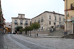
The town today maintains the old, poorly maintained center of Byzantine origin. There are remains of later centuries, such as the palaces of the 17th and 18th centuries, since the Spanish monarchs in the 17th century sent the noble family of the Portiglia to have complete control of the surrounding territory. Among the ancient palaces, those of the Portiglia, the Aquila family (17th century), and those of the Filomarino and Ferrari families from the 18th century stand out. Also, the churches are very old: Santa Maria Maggiore was built in the 15th century, San Nicola Pontefice and the Annunziata in the 17th century.

Recent archaeological investigations have allowed the discovery of a large major complex dating back to the Old and Middle Bronze Age (early 2nd millennium BC). This complex is framed in the context of the Capo Piccolo facies, which has close cultural and economic ties with the Capo Graziano, Sicilian Rodì and Salentian Apulian facies. The two bronze axes, with raised edges, which were found in the area in 1987 and are currently on display at the National Archaeological Museum in Crotone, date back to the same facies. One of the two axes, finely decorated with geometric drawings made with a burin, has been declared unique in Europe. It is assumed that the two axes, along with a dagger (now missing), were part of the funerary decoration of a high-ranking person.

Recently, new archaeological excavations in the Foresta locality for the construction of a new school have revealed the remains of a small rural building from the end of the Hellenistic period (3rd century BC).

In the historic center, in front of the current façade of the Church of San Nicola Pontefice, a cemetery with rock-cut tombs, some with multiple burials, dating back to the 17th century, was revealed. Other important remains, including ceramics and coins, have been found in the same excavation. According to Greek mythology, the city of Petelia was founded by Philoctetes, the archer famous for having killed Paris in the Trojan War.

On the mountains near the town, there are the convent and the church of the Santa Spina. The church, in Baroque style, dates back to 1600 and houses a thorn from the crown of Jesus Christ, donated in 1498 by Joan of Valois, Queen of France, (wife of Louis XII), to her personal confessor, Father Dionisio Sacco, bishop of Reims. The latter decided to take it to his monastery of origin, the Franciscan monastery of Petilia Policastro.

The town was home to Pope Anterus during the 3rd century. [3]

Economy

The town relies on the production of olive oil, wine, cereals, citruses, the processing of timber from the local La Sila mountains, and the breeding of cattle.

Related Research Articles

<span class="mw-page-title-main">Salamis, Cyprus</span> Ancient city-state and archaeological site on Cyprus

Salamis was an ancient Greek city-state on the east coast of Cyprus, at the mouth of the river Pedieos, 6 km north of modern Famagusta. According to tradition, the founder of Salamis was Teucer, son of Telamon, king of the Greek island of Salamis, who could not return home after the Trojan war because he had failed to avenge his brother Ajax.

<span class="mw-page-title-main">Crotone</span> Comune in Calabria, Italy

Crotone is a city and comune in Calabria, Italy. Founded c. 710 BCE as the Achaean colony of Kroton in Magna Graecia, it was known as Cotrone from the Middle Ages until 1928, when its name was changed to the current one. In 1992, it became the capital of the newly established Province of Crotone. As of August 2018, its population was about 65,000.

<span class="mw-page-title-main">Poros</span> Place in Greece

Poros is a small Greek island-pair in the southern part of the Saronic Gulf, about 58 km south from the port of Piraeus and separated from the Peloponnese by a 200 m (656 ft) wide sea channel, with the town of Galatas on the mainland across the strait. Its surface area is about 31 square kilometres (12 sq mi) and it has 3,780 inhabitants. The ancient name of Poros was Pogon. Like other ports in the Saronic, it is a popular weekend destination for Athenian travellers.

<span class="mw-page-title-main">Archaeology of Israel</span> Archaeological studies of Israel

The archaeology of Israel is the study of the archaeology of the present-day Israel, stretching from prehistory through three millennia of documented history. The ancient Land of Israel was a geographical bridge between the political and cultural centers of Mesopotamia and Egypt. Despite the importance of the country to three major religions, serious archaeological research only began in the 15th century. Although he never travelled to the Levant, or even left the Netherlands, the first major work on the antiquities of Israel is considered to be Adriaan Reland's Antiquitates Sacrae veterum Hebraeorum, published in 1708. Edward Robinson, an American theologian who visited the country in 1838, published its first topographical studies. Lady Hester Stanhope performed the first modern excavation at Ashkelon in 1815. A Frenchman, Louis Felicien de Saucy, embarked on early "modern" excavations in 1850. Today, in Israel, there are some 30,000 sites of antiquity, the vast majority of which have never been excavated.

<span class="mw-page-title-main">Province of Crotone</span> Province of Italy

The province of Crotone is a province in the Calabria region of southern Italy. It was formed in 1992 out of a section of the province of Catanzaro. The provincial capital is the city of Crotone. It borders the provinces of Cosenza, Catanzaro, and also the Ionian Sea. It contains the mountain Pizzuta, the National Park of the Sila, Montagnella Park, and the Giglietto Valley. Crotone was founded in 710 BCE. It participated in the Second Punic War against the Roman Republic.

Petilia or Petelia was a city name found in some ancient works of classical antiquity. It's widely accepted that in antiquity there were two cities with this name, both located in Southern Italy. One of them, Petilia, was located in ancient Lucania, while the second one, Petelia, was located on the coast of Bruttium.

<span class="mw-page-title-main">Arycanda</span> Ancient settlement in Anatolia

Arycanda or Arykanda is an Ancient Lycian city, former bishopric and present Catholic titular see in Antalya Province in the Mediterranean Region of Turkey.

<span class="mw-page-title-main">Pallagorio</span> Comune in Calabria, Italy

Pallagorio is a comune and town in the province of Crotone, in Calabria, Italy.

<span class="mw-page-title-main">Nocera Superiore</span> Comune in Campania, Italy

Nocera Superiore is a town and comune in the province of Salerno in the Campania region of south-western Italy.

<span class="mw-page-title-main">Papasidero</span> Comune in Calabria, Italy

Papasidero is a village and comune in the province of Cosenza in the Calabria region, southern Italy. It is part of Pollino National Park.

<span class="mw-page-title-main">Agios Sozomenos</span> Place in Nicosia District, Cyprus

Agios Sozomenos is a deserted village in the Nicosia District of Cyprus, close to the Green Line and near Potamia. It is located at the confluence of the Alikos river with the Gialias, the second-longest river of Cyprus.

<span class="mw-page-title-main">Tas-Silġ</span> Multi-period sanctuary and archaeological site

Tas-Silġ is a rounded hilltop on the south-east coast of the island of Malta, overlooking Marsaxlokk Bay, and close to the town of Żejtun. Tas-Silġ is a major multi-period sanctuary site with archaeological remains covering four thousand years, from the neolithic to the ninth century AD. The site includes a megalithic temple complex dating from the early third millennium BC, to a Phoenician and Punic sanctuary dedicated to the goddess Astarte. During the Roman era, the site became an international religious complex dedicated to the goddess Juno, helped by its location along major maritime trading routes, with the site being mentioned by first-century BC orator Cicero.

<span class="mw-page-title-main">Kaman-Kalehöyük</span> Archaeological site in Kırşehir Province, Turkey

Kaman-Kalehöyük is a multi-period archaeological site in Kırşehir Province, Turkey, around 100 km south east of Ankara, 6 km east of the town center of Kaman. It is a tell or mound site that was occupied during the Bronze Age, Iron Age and Ottoman periods. Excavations in the mound have been carried out since 1986 under the direction of Sachihiro Omura, on behalf of the Middle Eastern Culture Center in Japan and the Japanese Anatolian Archeology Institute. The distance to Hattusa, the Hittite capital, is about 100km.

<span class="mw-page-title-main">Khirbet Qana</span>

Khirbet Qana, is an archaeological site in the Lower Galilee of Israel. It has remains of a settlement from the Hellenistic to the Early Arab period. It has been associated with the Marriage at Cana of the New Testament.

<span class="mw-page-title-main">Church of Saint John the Baptist, Ein Karem</span> Roman Catholic church in Jerusalem

The Church of Saint John the Baptist is a Catholic church in Ein Karem, Jerusalem, that belongs to the Franciscan order. It was built at the site where Saint John the Baptist is believed to have been born.

Tell Judaidah is an archaeological site in south-eastern Turkey, in the Hatay province. It is one of the largest excavated ancient sites in the Amuq valley, in the plain of Antioch. Settlement at this site ranges from the Neolithic through the Byzantine Period.

<span class="mw-page-title-main">Archaeology of the Channel Islands</span>

Archaeology is promoted in Jersey by the Société Jersiaise and by Jersey Heritage. Promotion in the Bailiwick of Guernsey being undertaken by La Société Guernesiaise, Guernsey Museums, the Alderney Society with World War II work also undertaken by Festung Guernsey.

This page lists major archaeological events of 2017.

<span class="mw-page-title-main">Alepotrypa Cave</span> Cave and archaeological site in the Mani region of the Peloponnese peninsula of Greece

The Alepotrypa Cave is an archaeological site in the Mani region of the Peloponnese peninsula. In addition to being inhabited by early farmers, this site was used for burial and cult purposes. Archaeological evidence has revealed that this is one of the largest Neolithic burial sites ever found in Europe. Two adult human skeletons were found at the site from a burial dating to the 4th millennium BC, as well as remains from at least 170 separate persons. Archaeologists are uncertain about the significance of a Mycenaen ossuary, which has been dated to the 2nd millennium BC and appears to have been reburied at Alepotrypa. While there is no direct evidence, it is possible that the ossuary may link Alepotrypa to Tainaron, which was regarded as the entrance to Hades in classical mythology.

<span class="mw-page-title-main">Ancient Pydna</span> Ancient Greek city in Pieria, Central Macedonia, Greece

Pydna is an ancient Greek city in the regional unit of Pieria, Central Macedonia, Greece. It is an important place in the history of Pieria and a major archaeological site located directly at the Aegean Sea, 16 km northeast of Katerini, 28 km north-east of Dion and 2.5 km from the village of Makrygialos. Nearby are two Macedonian tombs, discovered by the French archaeologist Heuzey during his Greek travels in the mid-19th century. Furthermore, the fortress-like bishop's seat Louloudies is located a few kilometers south of Pydna.

References

  1. "Superficie di Comuni Province e Regioni italiane al 9 ottobre 2011". Italian National Institute of Statistics. Retrieved 16 March 2019.
  2. "Popolazione Residente al 1° Gennaio 2018". Italian National Institute of Statistics. Retrieved 16 March 2019.
  3. de Montor, Artaud (1911). The Lives and Times of the Popes: Including the Complete Gallery of Portraits of the Pontiffs Reproduced from Effigies Pontificum Romanorum Dominici Basae : Being a Series of Volumes Giving the History of the World During the Christian Era. New York: The Catholic Publication Society of America. pp. 49–50. OCLC   7533337.