Gosford is a New South Wales suburb located in the heart of the Central Coast Region, about 76 kilometres (47 mi) north of the Sydney CBD. The suburb is situated at the northern extremity of Brisbane Water, an extensive northern branch of the Hawkesbury River estuary and Broken Bay.
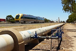
Kalgoorlie-Boulder, known colloquially as just Kalgoorlie, is a city in the Goldfields-Esperance region of Western Australia, located 595 km (370 mi) east-northeast of Perth at the end of the Great Eastern Highway. The city was founded in 1889 by the amalgamation of the towns of Kalgoorlie and Boulder, which developed in 1893 during the Coolgardie gold rush, on Western Australia's "Golden Mile". It is also the ultimate destination of the Goldfields Water Supply Scheme and the Golden Pipeline Heritage Trail.

Kanowna is a ghost town in the Goldfields region of Western Australia, about 20 kilometres (12 mi) east of Kalgoorlie. It is sited on Maduwongga tribal lands. At the 2016 census, Kanowna had a population of 10 people.

The Eastern Suburbs is the metropolitan region directly to the east and south-east of the central business district in Sydney, New South Wales, Australia.

Southern Cross is a town in Western Australia, 371 kilometres east of state capital Perth on the Great Eastern Highway. It was founded by gold prospectors in 1888, and gazetted in 1890. It is the major town and administrative centre of the Shire of Yilgarn. At the 2016 census, Southern Cross had a population of 680.

Cue is a small town in the Mid West region of Western Australia, located 620 km north-east of Perth. At the 2016 census, Cue had a population of 178. It is also known as the Queen of the Murchison. Cue is administered through the Cue Shire Council, which has its chambers in the historic Gentlemans Club building. The current president is Ross Pigdon. The Cue Parliament is held twice yearly in May and November.
Parkeston is a suburb of the city of Kalgoorlie, Western Australia, located 3 km east of the city centre. At the 2016 census, it had a population of 60 people, down from 69 in 2006.

Boulder is a suburb in the Western Australian Goldfields 595 kilometres (370 mi) east of Perth and bordering onto the town of Kalgoorlie in the Eastern Goldfields region.
North Gosford is a south-eastern suburb of the Central Coast region of New South Wales, Australia immediately north-east of Gosford's central business district. It is part of the Central Coast Council local government area.
Lake Gardens is a relatively new suburb on the western rural-urban fringe of Ballarat, Victoria Australia located near Lake Wendouree and directly behind the Ballarat Botanical Gardens from which the suburb draws its name. The suburb is bounded by Gillies Street to the east, O'Donnell's Road to the west and Gregory Street West to the north. The population at the 2016 census was 1,695.

Townsville City is the central suburb of the city of Townsville, Queensland, Australia. It is the city's central business district. Townsville CBD is a major hub for businesses of all sectors in the Northern Australia region. In the 2011 census, Townsville City had a population of 2,500 people.

The City of Kalgoorlie-Boulder is a local government area in the Goldfields-Esperance region of Western Australia, about 550 kilometres (342 mi) east of the state capital, Perth. The City covers an area of 95,575 square kilometres (36,902 sq mi), and its seat of government is the town of Kalgoorlie; all but 244 of the city's population live in either Kalgoorlie or Boulder.

Mount Warrigal is a large suburb of Shellharbour, New South Wales, Australia. The population, according to the 2016 Australian Census, was 4,909. The suburb is in the Shellharbour City LGA.
Kalgoorlie is the central suburb of the Kalgoorlie-Boulder metropolitan area in the Goldfields-Esperance region of Western Australia.
Victory Heights is a residential suburb of Kalgoorlie-Boulder, a city in the Eastern Goldfields region of Western Australia. At the 2016 census it had a population of 893 people, down from 908 at the 2011 census.
Karlkurla is a locality in the Eastern Goldfields region of Western Australia. It is a suburb of Kalgoorlie-Boulder. At the 2016 census, Karlkurla had a population of 177 people, up from 42 in 2011. The names of Karlkurla and Kalgoorlie are derived from the same root, the local Aboriginal word for the silky pear.

Mullingar is a locality in the Eastern Goldfields region of Western Australia. It is a suburb of Kalgoorlie-Boulder. At the 2016 census, Mullingar had a population of 305 people, down from 343 in 2011.
Hannans is a residential suburb of Kalgoorlie-Boulder, a city in the Eastern Goldfields region of Western Australia. At the 2016 census it had a population of 2,546 people, up from 2,483 in 2011. Hannans is named after Paddy Hannan, the prospector whose discovery of gold in 1893 led to the initial rush. The name Hannans originally referred to the Kalgoorlie townsite, and it was only much later in the city's history that it was applied to the current suburb.
Lamington is a residential suburb of Kalgoorlie-Boulder, a city in the Eastern Goldfields region of Western Australia. It had a population of 2,112 people at the 2011 census, down from 2,278 in 2011.