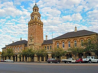
Kalgoorlie is a city in the Goldfields–Esperance region of Western Australia, located 595 km (370 mi) east-northeast of Perth at the end of the Great Eastern Highway. It is sometimes referred to as Kalgoorlie–Boulder, as the surrounding urban area includes the historic townsite of Boulder and the local government area is the City of Kalgoorlie–Boulder.

Kanowna is a ghost town in the Goldfields region of Western Australia, about 20 kilometres (12 mi) east of Kalgoorlie. It is sited on Maduwongga tribal lands. At the 2016 census, Kanowna had a population of 10 people.
Parkeston is a suburb of the city of Kalgoorlie, Western Australia, located 3 kilometres (1.9 mi) east of the city centre. At the 2016 census, it had a population of 60, down from 69 in 2006. It contains the Ninga Mia Aboriginal community.
Darch is a suburb of Perth, Western Australia, located within the City of Wanneroo approximately 17 kilometres (11 mi) north of the central business district. Previously part of Landsdale, much of the suburb was rural in character until the late 1990s. It was named after an early settler family in the area, with the name being approved in 1997. The area was subsequently opened to residential development, especially from 2001 onwards, as part of Cell 6 of the East Wanneroo Development Area.

Boulder is a suburb of Kalgoorlie in the Western Australian Goldfields, 597 kilometres (371 mi) east of Perth.
Victory Heights is a residential suburb of Kalgoorlie-Boulder, a city in the Eastern Goldfields region of Western Australia. At the 2016 census it had a population of 893 people, down from 908 at the 2011 census.
Karlkurla is a locality in the Eastern Goldfields region of Western Australia. It is a suburb of Kalgoorlie-Boulder. At the 2016 census, Karlkurla had a population of 177 people, up from 42 in 2011. The names of Karlkurla and Kalgoorlie are derived from the same root, the local Aboriginal word for the silky pear.

Mullingar is a locality in the Eastern Goldfields region of Western Australia. It is a suburb of Kalgoorlie-Boulder. At the 2016 census, Mullingar had a population of 305 people, down from 343 in 2011.
Piccadilly is a residential suburb of Kalgoorlie-Boulder, a city in the Eastern Goldfields region of Western Australia. At the 2016 census, it had a population of 2,263 people, down from 2,597 in 2011.
Lamington is a residential suburb of Kalgoorlie-Boulder, a city in the Eastern Goldfields region of Western Australia. It had a population of 2,112 people at the 2016 census, down from 2,278 in 2011.

Jubilee Pocket is a residential locality in the Whitsunday Region, Queensland, Australia. In the 2021 census, Jubilee Pocket had a population of 2,047 people.

Roseneath is an outer suburb of Townsville in the City of Townsville, Queensland, Australia. In the 2021 census, Roseneath had a population of 127 people.
Kambalda East is a town in the Goldfields-Esperance region of Western Australia, located in the Shire of Coolgardie local government area. It forms part of the broader Kambalda township, which is formally divided into Kambalda East and Kambalda West. Kambalda East recorded a population of 802 at the 2021 census.

South Boulder is a mixed-use suburb of Kalgoorlie-Boulder, a city in the Eastern Goldfields region of Western Australia.
West Kalgoorlie is an industrial suburb of Kalgoorlie-Boulder, a city in the Eastern Goldfields region of Western Australia.
South Kalgoorlie is a residential suburb of Kalgoorlie-Boulder, a city in the Eastern Goldfields region of Western Australia.
Williamstown is a mixed-use suburb of Kalgoorlie-Boulder, a city in the Eastern Goldfields region of Western Australia.
Broadwood is a mixed-use suburb of Kalgoorlie-Boulder, a city in the Eastern Goldfields region of Western Australia.

