
Charles Yelverton O'Connor,, was an Irish engineer who is best known for his work in Western Australia, especially the construction of Fremantle Harbour, thought to be impossible, and the Goldfields Water Supply Scheme.

Southern Cross is a town in Western Australia, 371 kilometres east of state capital Perth on the Great Eastern Highway. It was founded in 1888 after gold prospectors Richard Greaves and Ted Paine during their October 1887 expedition successfully found gold, and gazetted in 1890. It is the major town and administrative centre of the Shire of Yilgarn. At the 2016 census, Southern Cross had a population of 680.
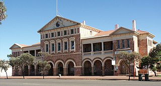
Coolgardie is a small town in Western Australia, 558 kilometres (347 mi) east of the state capital, Perth. It has a population of approximately 850 people.
The Eastern Goldfields Railway, historically also referred to as the Fremantle-Kalgoorlie Railway, was built in the 1890s by the Western Australian Government Railways to connect Perth with the Eastern Goldfields at Coolgardie and Kalgoorlie.

Menzies is a town in the Goldfields-Esperance region of Western Australia, 728 kilometres (452 mi) east-northeast of the state capital, Perth, and 133 kilometres (83 mi) north-northwest of the city of Kalgoorlie. At the 2016 census, Menzies had a population of 108. Aboriginal people have lived in this area since time immemorial, and the local group are the Kaburn Bardu.
Maurice Coleman Davies was an Australian timber merchant and pastoralist. Born in London, he emigrated to Tasmania with his family as a child, and later moved to Blackwood in the Victorian goldfields, then to Melbourne and Adelaide. He then relocated to Western Australia, where he created the M. C. Davies Company, later the M. C. Davies Karri and Jarrah Timber Company, a timber empire that employed hundreds of men, laid over a hundred kilometres of private railway, including the Flinders Bay Branch Railway, and even built its own private ports for exporting of timber. He also formed the Kimberley Pastoral Company and was its managing director.

Lake Carnegie is a large ephemeral lake in the Shire of Wiluna in the Goldfields-Esperance region of Western Australia. The lake is named after David Carnegie, who explored much of inland Western Australia in the 1890s. A similar lake lies to its south east - Lake Wells.

Civil disturbances in Western Australia include race riots, prison riots, and religious conflicts – often Protestant versus Catholic groups.
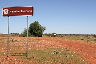
Nannine is a ghost town in the Mid West region of Western Australia. It is located on the northern bank of Lake Anneen, approximately 35 kilometres (22 mi) south-southwest of Meekatharra, and 735 kilometres (457 mi) north-northeast of Perth.

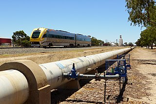
The Goldfields Water Supply Scheme is a pipeline and dam project that delivers potable water from Mundaring Weir in Perth to communities in Western Australia's Eastern Goldfields, particularly Coolgardie and Kalgoorlie. The project was commissioned in 1896 and completed in 1903.
The Eastern Goldfields is part of the Western Australian Goldfields in the Goldfields-Esperance region of Western Australia, covering the present and former gold-mining area east of Perth.

The network of railway lines in Western Australia associated with the timber and firewood industries is as old as the mainline railway system of the former Western Australian Government Railways system.
Peak Hill is the name of a goldfield, locality and the site of a gold mining ghost town in the Murchison Region of Western Australia. The gold mine covers 2,162 hectares and consists of four open-cut mines, titled: Main, Jubilee, Fiveways and Harmony.
The Goldfields region of Western Australia has an extensive array of active and historical mining operations and towns.
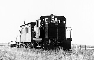
The Commonwealth Railways NC class consisted of two diesel-hydraulic locomotives built by Clyde Engineering, Granville, New South Wales in 1956. The Lakewood Firewood Company, Kalgoorlie was the first owner; the Commonwealth Railways purchased them in 1965. They ceased revenue service in the early 1980s.

The Gold Stealing Detection Unit (GSDU), or Gold Stealing Detective Squad (GSDS), is a special unit of the Western Australian Police, based in Kalgoorlie, Western Australia. It investigates criminal activity and allegations at all stages of the gold production process in the state.
Black Flag is an abandoned town in Western Australia, 30 km north west of Kalgoorlie. It is on the Black Flag to Ora Banda Road in the Goldfields-Esperance region of Western Australia.
Kurrawang is a town in Western Australia between Coolgardie and Kalgoorlie just off Great Eastern Highway in the Goldfields–Esperance region of Western Australia.

The Kalgoorlie to Kanowna railway line was a 20-kilometre (12 mi) long state government-owned and WAGR-operated railway line in the Goldfields–Esperance region of Western Australia, connecting Kalgoorlie to Kanowna. At Kalgoorlie, it connected to the Eastern Goldfields Railway.

The Kalgoorlie to Gnumballa Lake railway line was a set of state government-owned and WAGR-operated railway lines in the Goldfields–Esperance region of Western Australia. It connected Kalgoorlie to Lakeside, at Gnumballa Lake, as well as Boulder, through the Boulder Townsite Loop railway line and Brown Hill, through the Brown Hill Loop railway line. At Kalgoorlie, it connected to the Eastern Goldfields Railway. For a short duration in the 1920s, the railway line also continued on from Lakside to Brown Hill.
