Coolgardie is a small town in Western Australia, 558 kilometres (347 mi) east of the state capital, Perth. It has a population of approximately 850 people.
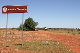
Nannine is a ghost town in the Mid West region of Western Australia. It is located on the northern bank of Lake Anneen, approximately 35 kilometres (22 mi) south-southwest of Meekatharra, and 735 kilometres (457 mi) north-northeast of Perth.

North-East Coolgardie was an electoral district of the Legislative Assembly in the Australian state of Western Australia from 1897 to 1901.

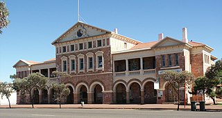
The City of Kalgoorlie–Boulder is a local government area in the Goldfields–Esperance region of Western Australia, about 550 kilometres (342 mi) east of the state capital, Perth. Covering an area of 95,575 square kilometres (36,902 sq mi), the city is the 12th largest in the world, larger than the country of Portugal with a land area of 92,212 square kilometres (35,603 sq mi). Its seat of government is the town of Kalgoorlie; all but 244 of the city's population live in either Kalgoorlie or Boulder.

Henry Gregory was an Australian politician. He was a Ministerialist member of the Western Australian Legislative Assembly from 1897 to 1911, representing the electorates of North Coolgardie (1897-1901) and Menzies (1901-1911). He was state Minister for Mines from 1901 to 1904 under George Leake and Walter James and Minister for Mines and Railways from 1905 to 1911 under Hector Rason, Newton Moore and Frank Wilson. He rose to become Treasurer from 1910 to 1911, a role that also entailed him acting as Premier if Wilson was absent, but lost his seat at the 1911 state election.
The Goldfields region of Western Australia has an extensive array of active and historical mining operations and towns.
Broad Arrow is a ghost town in Western Australia, located 38 km north of Kalgoorlie and 633 km east of Perth. It is on the Kalgoorlie to Leonora Road.
Bulong is an abandoned town in Western Australia located 580 kilometres (360 mi) east of Perth in the Goldfields-Esperance region of Western Australia.
Black Flag is an abandoned town in Western Australia, 30 km north west of Kalgoorlie. It is on the Black Flag to Ora Banda Road in the Goldfields-Esperance region of Western Australia.

Beria is an abandoned town in the Goldfields-Esperance region of Western Australia, located 8 kilometres (5 mi) north of Laverton on the Laverton-Leonora Road.
Bardoc is an abandoned town in the Goldfields-Esperance region of Western Australia. It is situated between Kalgoorlie and Menzies along the Goldfields Highway.
Feysville is an abandoned town in the Goldfields-Esperance region of Western Australia. It is situated between Kalgoorlie and Kambalda just off the Goldfields Highway.
Kurnalpi is an abandoned town in the Goldfields-Esperance region of Western Australia. It lies in what was once Maduwongga territory and is situated about 60 km north-east of Kalgoorlie.
Mulline is an abandoned town located in the Goldfields-Esperance region in Western Australia. It is found between Kalgoorlie and Leonora in the Shire of Menzies.
Windanya is a ghost town located between Kalgoorlie and Leonora in the Goldfields–Esperance region of Western Australia.
Mulwarrie is an abandoned town in the North Coolgardie Goldfield of the Goldfields-Esperance region of Western Australia, 125 km northwest of Kalgoorlie, between Davyhurst and Mulline.
State Batteries in Western Australia were government owned and run ore-crushing facilities for the gold mining industry. Western Australia was the only Australian state to provide batteries to assist gold prospectors and small mines. They existed in almost all of the mineral fields of Western Australia.
The Broad Arrow Road District was an early form of local government area on the Western Australian goldfields. It was established on 15 December 1899, providing basic local government to the rural areas around the mining town of Broad Arrow, which had already been incorporated as the Municipality of Broad Arrow in 1897. The board's office was located in Broad Arrow township.
The Municipality of Broad Arrow was a local government area in Western Australia centred on the mining town of Broad Arrow.
The Municipality of Broad Arrow-Paddington was a local government area in Western Australia centred on the mining towns of Broad Arrow and Paddington.
