
Norseman is a town located in the Goldfields-Esperance region of Western Australia along the Coolgardie-Esperance Highway, 726 kilometres (451 mi) east of Perth and 278 metres (912 ft) above sea level. It is also the starting point of the Eyre Highway, and the last major town in Western Australia before the South Australian border 720 kilometres (447 mi) to the east. At the 2016 census, Norseman had a population of almost 600.
Coolgardie is a small town in Western Australia, 558 kilometres (347 mi) east of the state capital, Perth. It has a population of approximately 850 people.

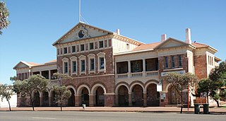
Menzies is a town in the Goldfields-Esperance region of Western Australia, 728 kilometres (452 mi) east-northeast of the state capital, Perth, and 133 kilometres (83 mi) north-northwest of the city of Kalgoorlie. At the 2016 census, Menzies had a population of 108. Aboriginal people have lived in this area since time immemorial, and the local group are the Kaburn Bardu.

The Shire of Menzies is a local government area in the Goldfields-Esperance region of Western Australia located to the north of Kalgoorlie. It covers an area of 124,635 square kilometres (48,122 sq mi), and its seat of government is the town of Menzies.
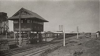
Kalgoorlie railway station is the most eastern attended station in Western Australia, located at the eastern terminus of the Eastern Goldfields Railway. It serves the city of Kalgoorlie. Beyond Kalgoorlie the line continues east as the Trans-Australian Railway.
Mining in Western Australia is administered in terms of the administrative divisions of the:-

Henry Gregory was an Australian politician. He was a Ministerialist member of the Western Australian Legislative Assembly from 1897 to 1911, representing the electorates of North Coolgardie (1897-1901) and Menzies (1901-1911). He was state Minister for Mines from 1901 to 1904 under George Leake and Walter James and Minister for Mines and Railways from 1905 to 1911 under Hector Rason, Newton Moore and Frank Wilson. He rose to become Treasurer from 1910 to 1911, a role that also entailed him acting as Premier if Wilson was absent, but lost his seat at the 1911 state election.

Broad Arrow is a ghost town in Western Australia, located 38 km north of Kalgoorlie and 633 km east of Perth, Western Australia. It is on the Kalgoorlie to Leonora Road.

Beria is an abandoned town in the Goldfields-Esperance region of Western Australia, located 8 kilometres (5 mi) north of Laverton on the Laverton-Leonora Road.
Bardoc is an abandoned town in the Goldfields-Esperance region of Western Australia. It is situated between Kalgoorlie and Menzies along the Goldfields Highway.
Waverley or Siberia is a ghost town located between Kalgoorlie and Leonora. It is on the Davyhurst to Ora Banda Road in the Goldfields-Esperance region of Western Australia and has formed part of Maduwongga territory.
Yundamindera, also once known as The Granites, is an abandoned town located between Leonora and Laverton in the Goldfields-Esperance region of Western Australia.
Callion is an abandoned town in the Goldfields-Esperance region in Western Australia. It is between Coolgardie and Leonora.
Mulwarrie is an abandoned town in the North Coolgardie Goldfield of the Goldfields-Esperance region of Western Australia, 125 km northwest of Kalgoorlie, between Davyhurst and Mulline.
Yerilla is an abandoned town located in the Goldfields-Esperance region in Western Australia. It is found between Kalgoorlie and Laverton.
Yunndaga is an abandoned town located in the Goldfields-Esperance region in Western Australia, between Kalgoorlie and Leonora along the Goldfields Highway.
State Batteries in Western Australia were government owned and run ore-crushing facilities for the gold mining industry. Western Australia was the only Australian state to provide batteries to assist gold prospectors and small mines. They existed in almost all of the mineral fields of Western Australia.
This is a list of newspapers published in, or for, the Goldfields-Esperance region of Western Australia.
Francis Ambrose Moss was a mine manager in Perth, Western Australia.
The community of Kalgoorlie-Boulder in the Eastern Goldfields of Western Australia had an energetic newspaper publishing industry in the late 1890s and early 1900s.

