The human history of Western Australia commenced between 40,000 and 60,000 years ago with the arrival of Aboriginal Australians on the northwest coast. The first inhabitants expanded across the east and south of the continent.

Katanning is a town located 277 kilometres (172 mi) south-east of Perth, Western Australia on the Great Southern Highway. At the 2016 census, Katanning had a population of 3,687.

Cue is a small town in the Mid West region of Western Australia, located 620 km north-east of Perth. At the 2016 census, Cue had a population of 178. Cue is administered through the Cue Shire Council, which has its chambers in the historic Gentlemans Club building. The current president is Ross Pigdon. The Cue Parliament is held twice yearly in May and November.

Gwalia is a former gold-mining town located 233 kilometres (145 mi) north of Kalgoorlie and 828 kilometres (514 mi) east of Perth in Western Australia's Great Victoria Desert. Today, Gwalia is essentially a ghost town, having been largely deserted since the main source of employment, the Sons of Gwalia gold mine, closed in 1963. Just 4 kilometres (2.5 mi) north is the town of Leonora, which remains the hub for the area's mining and pastoral industries.
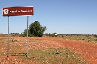
Nannine is a ghost town in the Mid West region of Western Australia. It is located on the northern bank of Lake Anneen, approximately 35 kilometres (22 mi) south-southwest of Meekatharra, and 735 kilometres (457 mi) north-northeast of Perth.
Bulong is an abandoned town in Western Australia located 580 kilometres (360 mi) east of Perth in the Goldfields-Esperance region of Western Australia.
Lawlers is a ghost town on the Old Agnew Road, 982 kilometres (610 mi) northeast of Perth, Western Australia, in the Shire of Leonora in the Goldfields-Esperance region of Western Australia.
Mount Margaret was an abandoned town located 900 kilometres (559 mi) northeast of Perth and 31 kilometres (19 mi) southwest of Laverton in the Goldfields-Esperance region of Western Australia.
Black Flag is an abandoned town in Western Australia, 30 km north west of Kalgoorlie. It is on the Black Flag to Ora Banda Road in the Goldfields-Esperance region of Western Australia.

During the Australian gold rushes, starting in 1851, significant numbers of workers moved from elsewhere in Australia and overseas to where gold had been discovered. Gold had been found several times before, but the colonial government of New South Wales had suppressed the news out of the fear that it would reduce the workforce and so destabilise the economy.

Beria is an abandoned town in the Goldfields-Esperance region of Western Australia, located 8 kilometres (5 mi) north of Laverton on the Laverton-Leonora Road.
Bardoc is an abandoned town in the Goldfields-Esperance region of Western Australia. It is situated between Kalgoorlie and Menzies along the Goldfields Highway.
Kurnalpi is an abandoned town in the Goldfields-Esperance region of Western Australia. It lies in what was once Maduwongga territory and is situated between Norseman and Laverton.
Kundana is an abandoned town in Western Australia located between Coolgardie and Bardoc in the Goldfields–Esperance region of Western Australia.
Sir Samuel is an abandoned town located between Leinster and Wiluna in the Goldfields-Esperance region of Western Australia.
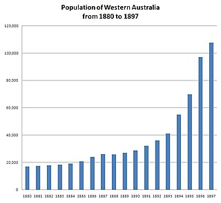
In the latter part of the nineteenth century, discoveries of gold at a number of locations in Western Australia caused large influxes of prospectors from overseas and interstate, and classic gold rushes. Significant finds included:
Cuddingwarra is an abandoned town in the Mid West region of Western Australia. The town is located between Cue and Big Bell.
Callion is an abandoned town in the Goldfields-Esperance region in Western Australia. It is between Coolgardie and Leonora, in the Shire of Menzies.
Niagara is an abandoned town located in the Goldfields-Esperance region in Western Australia, between Kalgoorlie and Leonora, 12 kilometres (7.5 mi) southwest of Kookynie.
Yerilla is an abandoned town located in the Goldfields-Esperance region in Western Australia. It is found between Kalgoorlie and Laverton.
