Laverton, originally known as British Flag, is a town in the Goldfields region of Western Australia, and the centre of administration for the Shire of Laverton. The town of Laverton is located at the western edge of the Great Victoria Desert, 957 kilometres (595 mi) north-northeast of the state capital, Perth, and 124 kilometres (77 mi) east-northeast of the town of Leonora, with an elevation of 461 metres (1,512 ft).
Marvel Loch is a small townsite of fewer than 100 people, 401 kilometres (249 mi) east of Perth, Western Australia. It is located 32 kilometres (20 mi) south west of Southern Cross, along the Perth to Kalgoorlie Great Eastern Highway. The town is located in the Shire of Yilgarn.

Sandstone is a small town in the Mid West region of Western Australia 157 kilometres (98 mi) east of Mount Magnet and 661 kilometres (411 mi) north of the state capital, Perth. At the 2016 census, Sandstone and the surrounding Shire of Sandstone had a population of 89 people, including 19 families. Sandstone is the administrative centre and only town in the Shire of Sandstone local government area.
Abbotts is an abandoned town in Western Australia located in the Murchison Goldfields region of Western Australia and 31 km (19 mi) north-west of Meekatharra on the Meekatharra – Mount Clere Road.

Austin is an abandoned town in the Murchison region of Western Australia. The town is located south of Cue on an island in Lake Austin and for this reason was also known as Lake Austin and The Island Lake Austin.
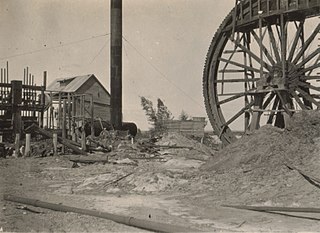
The Davyhurst Gold Mine is a gold mine located 53 km south-west of Menzies, near Davyhurst.
Balagundi is an abandoned town in Western Australia, 20 km east of Kalgoorlie. It is between Kalgoorlie and Bulong in the Goldfields-Esperance region of Western Australia within the City of Kalgoorlie-Boulder.

Beria is an abandoned town in the Goldfields-Esperance region of Western Australia, located 8 kilometres (5 mi) north of Laverton on the Laverton-Leonora Road.
Comet Vale is an abandoned town in Western Australia located in the Goldfield region of Western Australia located between Kalgoorlie and Laverton on the Goldfields Highway. It is within the Shire of Menzies.
Burbanks is an abandoned town in Western Australia located between Coolgardie and Londonderry in the Goldfields-Esperance region of Western Australia.
Bardoc is an abandoned town in the Goldfields-Esperance region of Western Australia. It is situated between Kalgoorlie and Menzies along the Goldfields Highway.
Dunnsville is an abandoned town in Western Australia located 46 km north-west of Coolgardie in the Goldfields-Esperance region of Western Australia.
Kathleen is an abandoned town located between Leinster and Wiluna along the Goldfields Highway in the Goldfields-Esperance region of Western Australia.
Kurrajong is an abandoned town located between Leonora and Leinster along the Old Agnew Road in the Goldfields–Esperance region of Western Australia.
Princess Royal is an abandoned town in the Goldfields–Esperance region in Western Australia. It was named after a gold mine that was the basis for the town. The mine was named after Victoria, Princess Royal, eldest daughter of Queen Victoria. It was located near Norseman.
Waverley, or Siberia, is a ghost town located between Kalgoorlie and Leonora. It is on the Davyhurst to Ora Banda Road in the Goldfields-Esperance region of Western Australia and has formed part of Maduwongga territory.
Callion is an abandoned town in the Goldfields-Esperance region in Western Australia. It is between Coolgardie and Leonora, in the Shire of Menzies.
Mulwarrie is an abandoned town in the North Coolgardie Goldfield of the Goldfields-Esperance region of Western Australia, 125 km northwest of Kalgoorlie, between Davyhurst and Mulline.
Yarri is an abandoned town located in the Goldfields–Esperance region in Western Australia. It is located between Kalgoorlie and Laverton in the Shire of Menzies.
Yunndaga is an abandoned town located in the Goldfields-Esperance region in Western Australia, between Kalgoorlie and Leonora along the Goldfields Highway.
