Kalgoorlie is a city in the Goldfields–Esperance region of Western Australia, located 595 km (370 mi) east-northeast of Perth at the end of the Great Eastern Highway. It is sometimes referred to as Kalgoorlie–Boulder, as the surrounding urban area includes the historic townsite of Boulder and the local government area is the City of Kalgoorlie–Boulder.

Kanowna is a ghost town in the Goldfields region of Western Australia, about 20 kilometres (12 mi) east of Kalgoorlie. It is sited on Maduwongga tribal lands. At the 2016 census, Kanowna had a population of 10 people.
Coolgardie is a small town in Western Australia, 558 kilometres (347 mi) east of the state capital, Perth. It has a population of approximately 850 people.
Grass Valley is a small townsite 13 kilometres (8 mi) east of Northam, Western Australia in the Avon Valley area.
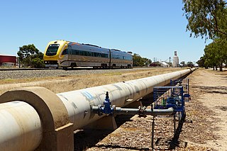
The Eastern Goldfields Railway was built in the 1890s by the Western Australian Government Railways to connect Perth with the Eastern Goldfields at Coolgardie and Kalgoorlie.

Menzies is a town in the Goldfields-Esperance region of Western Australia, 728 kilometres (452 mi) east-northeast of the state capital, Perth, and 133 kilometres (83 mi) north-northwest of the city of Kalgoorlie. At the 2016 census, Menzies had a population of 108. Aboriginal people have lived in this area since time immemorial, and the local group are the Kaburn Bardu.

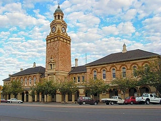
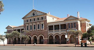
The City of Kalgoorlie–Boulder is a local government area in the Goldfields–Esperance region of Western Australia, about 550 kilometres (342 mi) east of the state capital, Perth. Covering an area of 95,575 square kilometres (36,902 sq mi), the city is the 12th largest in the world, larger than the country of Portugal with a land area of 92,212 square kilometres (35,603 sq mi). Its seat of government is the town of Kalgoorlie; all but 244 of the city's population live in either Kalgoorlie or Boulder.
Broad Arrow is a ghost town in Western Australia, located 38 km north of Kalgoorlie and 633 km east of Perth. It is on the Kalgoorlie to Leonora Road.
Bulong is an abandoned town in Western Australia located 580 kilometres (360 mi) east of Perth in the Goldfields-Esperance region of Western Australia.
Black Flag is an abandoned town in Western Australia, 30 km north west of Kalgoorlie. It is on the Black Flag to Ora Banda Road in the Goldfields-Esperance region of Western Australia.
Balagundi is an abandoned town in Western Australia, 20 km east of Kalgoorlie. It is between Kalgoorlie and Bulong in the Goldfields-Esperance region of Western Australia within the City of Kalgoorlie-Boulder.
Comet Vale is an abandoned town in Western Australia located in the Goldfield region of Western Australia located between Kalgoorlie and Laverton on the Goldfields Highway. It is within the Shire of Menzies.
Bardoc is an abandoned town in the Goldfields-Esperance region of Western Australia. It is situated between Kalgoorlie and Menzies along the Goldfields Highway.
Feysville is an abandoned town in the Goldfields-Esperance region of Western Australia. It is situated between Kalgoorlie and Kambalda just off the Goldfields Highway.
Gudarra is an abandoned town in the Goldfields-Esperance region of Western Australia. It is situated between Kalgoorlie and Menzies off the Goldfields Highway. The present-day Paddington Gold Mine is located near the old townsite.
Mulline is an abandoned town located in the Goldfields-Esperance region in Western Australia. It is found between Kalgoorlie and Leonora in the Shire of Menzies.
Sir Samuel is an abandoned town located between Leinster and Wiluna in the Goldfields-Esperance region of Western Australia.
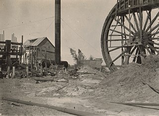
In the latter part of the nineteenth century, discoveries of gold at a number of locations in Western Australia caused large influxes of prospectors from overseas and interstate, and classic gold rushes. Significant finds included:
Niagara is an abandoned town located in the Goldfields-Esperance region in Western Australia, between Kalgoorlie and Leonora, 12 kilometres (7.5 mi) southwest of Kookynie.
Yerilla is an abandoned town located in the Goldfields-Esperance region in Western Australia. It is found between Kalgoorlie and Laverton.

