
Wubin is located in the northern Wheatbelt region, 272 kilometres (169 mi) north-northeast of Perth and 21 kilometres (13 mi) north of Dalwallinu.

The town of Hyden is located 292 kilometres (181 mi) east-southeast of Perth, Western Australia in the Shire of Kondinin. Hyden is home to Wave Rock, Mulka's Cave and Hippos Yawn, all popular local tourist attractions.

Broomehill is a town on the Great Southern Highway between Katanning and Albany, in the Great Southern region of Western Australia. Its local government area is the Shire of Broomehill-Tambellup.
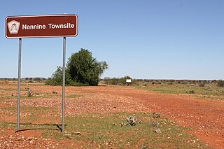
Nannine is a ghost town in the Mid West region of Western Australia. It is located on the northern bank of Lake Anneen, approximately 35 kilometres south-southwest of Meekatharra, and 735 kilometres north-northeast of Perth.

Yealering is a town in the Wheatbelt region of Western Australia, approximately 220 km south-east of Perth between the towns of Wickepin and Corrigin. It is located beside the lake of the same name. While the town's population is small, it services a large agricultural district in the northern Wickepin Shire. At the 2016 census, Yealering had a population of 104.

Koorda is a town in the north eastern Wheatbelt region of Western Australia, approximately 236 kilometres (147 mi) east of Perth and 43 kilometres (27 mi) north of Wyalkatchem at the northeastern end of the Cowcowing Lakes. It is the main town in the Shire of Koorda. At the 2006 census, Koorda had a population of 260.

Sandstone is a small town in the Mid West region of Western Australia 157 kilometres (98 mi) east of Mount Magnet and 661 kilometres (411 mi) north of the state capital, Perth. At the 2016 census, Sandstone and the surrounding Shire of Sandstone had a population of 89 people, including 19 families. Sandstone is the administrative centre and only town in the Shire of Sandstone local government area.

Austin is an abandoned town in the Murchison region of Western Australia. The town is located south of Cue on an island in Lake Austin and for this reason was also known as Lake Austin and The Island Lake Austin.

Lake King is a town in the eastern Wheatbelt region of Western Australia, 464 kilometres (288 mi) from Perth along State Route 40 between Kelmscott and Ravensthorpe. As of 2016, the town had a population of 95. The 2011 census recorded both the population of the town and the surrounding area for a population of 332.

The Lawlers Gold Mine is a gold mine located 23 km south west of Leinster, Western Australia.

Bulong is an abandoned town in Western Australia located 580 kilometres (360 mi) east of Perth in the Goldfields-Esperance region of Western Australia.
Lawlers is a ghost town on the Old Agnew Road, 982 kilometres (610 mi) northeast of Perth, in the Goldfields-Esperance region of Western Australia.
Mount Margaret was an abandoned town located 900 kilometres (559 mi) northeast of Perth and 31 kilometres (19 mi) southwest of Laverton in the Goldfields-Esperance region of Western Australia.
Varley is a small town located between Hyden and Lake King in the Wheatbelt region of Western Australia.
Buldania is an abandoned town north-east of Norseman in the Goldfields-Esperance region of Western Australia. The small townsite, located about 8 kilometres (5 mi) north of the Eyre Highway, serviced a field which was discovered in June 1896 by Arthur Bell. Despite the high yield of ore which was obtained, progress was slow due to the difficult terrain of the Fraser Range combined with a lack of capital to develop the area. By the end of 1897 it had a population of 51, notably including only one female. By April 1901, this had fallen to 18 and by 1903, the Western Argus noted the area was "unfortunately practically deserted". This was confirmed by an official report in May 1906: "Some 10 or 11 leases have at times been applied for and worked to some extent. All are now abandoned, and the field quite deserted."
Kunanalling is an abandoned town in Western Australia located between Coolgardie and Balgarri along the Coolgardie North Road in the Goldfields-Esperance region of Western Australia.
Sir Samuel is an abandoned town located between Leinster and Wiluna in the Goldfields-Esperance region of Western Australia.
Porlell is a ghost town located in the Mid West region of Western Australia. It is found between the towns of Nannine and Gabanintha. The town is situated within the Murchison goldfields.
Niagara is an abandoned town located in the Goldfields-Esperance region in Western Australia. It is found between Kalgoorlie and Leonora, 12 kilometres (7.5 mi) southwest of Kookynie.
Yerilla is an abandoned town located in the Goldfields-Esperance region in Western Australia. It is found between Kalgoorlie and Laverton.
