
Kanowna is a ghost town in the Goldfields region of Western Australia, about 20 kilometres (12 mi) east of Kalgoorlie. At the 2016 census, Kanowna had a population of 10 people.
Laverton, originally known as British Flag, is a town in the Goldfields region of Western Australia, and the centre of administration for the Shire of Laverton. The town of Laverton is located at the western edge of the Great Victoria Desert, 957 kilometres (595 mi) north-northeast of the state capital, Perth, and 124 kilometres (77 mi) east-northeast of the town of Leonora, with an elevation of 461 metres (1,512 ft).

Southern Cross is a town in Western Australia, 371 kilometres east of state capital Perth on the Great Eastern Highway. It was founded in 1888 after gold prospectors Richard Greaves and Ted Paine during their October 1887 expedition successfully found gold, and gazetted in 1890. It is the major town and administrative centre of the Shire of Yilgarn. At the 2016 census, Southern Cross had a population of 680.
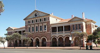
Coolgardie is a small town in Western Australia, 558 kilometres (347 mi) east of the state capital, Perth. It has a population of approximately 850 people.

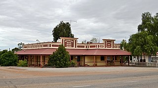
Kookynie is a town located in the Goldfields–Esperance region of Western Australia. The name of the town is believed to be an Aboriginal word that means "waterhole" or "spring". From being a busy town with a population of around 1,500 in 1905, Kookynie has become a ghost town, with around 77 inhabitants in 2006 and 99 in 2021.

Bodallin is a town located around halfway between Merredin and Southern Cross in Western Australia.
Moorine Rock is located in the eastern agricultural region of Western Australia, 347 km east of Perth and 22 km west south west of Southern Cross.

Doodlakine is a town 220 km (140 mi) east of Perth, Western Australia. It is within the Shire of Kellerberrin along the Great Eastern Highway. The town has a crossing loop for trains on the Perth-to-Kalgoorlie railway and serves as a stop on the MerredinLink rural train service.

Meckering is a town 130 kilometres (80.8 mi) east of Perth, Western Australia along the Great Eastern Highway. Meckering is located within the Shire of Cunderdin.
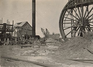
Peak Hill is the name of a goldfield, locality and the site of a gold mining ghost town in the Murchison Region of Western Australia. The gold mine covers 2,162 hectares and consists of four open-cut mines, titled: Main, Jubilee, Fiveways and Harmony.

Burtville is an abandoned town in the Goldfields-Esperance region of Western Australia, located 29 kilometres (18 mi) south east of Laverton.
Bulong is an abandoned town in Western Australia located 580 kilometres (360 mi) east of Perth in the Goldfields-Esperance region of Western Australia.
Black Flag is an abandoned town in Western Australia, 30 km north west of Kalgoorlie. It is on the Black Flag to Ora Banda Road in the Goldfields-Esperance region of Western Australia.
Comet Vale is an abandoned town in Western Australia located in the Goldfield region of Western Australia located between Kalgoorlie and Laverton on the Goldfields Highway. It is within the Shire of Menzies.
Bardoc is an abandoned town in the Goldfields-Esperance region of Western Australia. It is situated between Kalgoorlie and Menzies along the Goldfields Highway.
Dunnsville is an abandoned town in Western Australia located 46 km north-west of Coolgardie in the Goldfields-Esperance region of Western Australia.
Gudarra is an abandoned town in the Goldfields-Esperance region of Western Australia. It is situated between Kalgoorlie and Menzies off the Goldfields Highway. The present-day Paddington Gold Mine is located near the old townsite.
Londonderry is a ghost town in Western Australia, located 14 km South West of Coolgardie in the Goldfields-Esperance region of Western Australia.
Paynesville is a ghost town and locality in the Mid West region of Western Australia between the towns of Mount Magnet and Sandstone.

Mullingar is a locality in the Eastern Goldfields region of Western Australia. It is a suburb of Kalgoorlie–Boulder. At the 2016 census, Mullingar had a population of 305 people, down from 343 in 2011.

