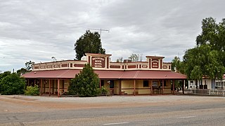
Katanning is a town located 277 kilometres (172 mi) south-east of Perth, Western Australia on the Great Southern Highway. At the 2016 census, Katanning had a population of 3,687.

Merredin is a town in Western Australia, located in the central Wheatbelt roughly midway between Perth and Kalgoorlie, on Route 94, Great Eastern Highway. It is located on the route of the Goldfields Water Supply Scheme, and as a result is also on the Golden Pipeline Heritage Trail.

Yalgoo is a town in the Mid West region, 499 kilometres (310 mi) north-north-east of Perth, Western Australia and 118 kilometres (73 mi) east-north-east of Mullewa. Yalgoo is in the local government area of the Shire of Yalgoo.

The townsite of Tambellup is located in the Great Southern region of Western Australia, 317 km south-east of Perth on the Great Southern Highway where it crosses the Gordon River. It is 23 km south of Broomehill.

Moorine Rock is located in the eastern agricultural region of Western Australia, 347 km east of Perth and 22 km west south west of Southern Cross.

Three Springs is a town located 313 kilometres (194 mi) north of Perth, Western Australia on the Midlands Road, which until the opening of the Brand Highway in 1975 was the main road route from Perth to the state's north. The town is the seat of the Shire of Three Springs. Its economy is based on agriculture and mining.
The lands administrative divisions of Western Australia refer to subdivisions of the state of Western Australia for cadastral purposes, most of which have been in place since the 19th century. The state is divided up for this purpose into five land divisions, which in turn are subdivided into land districts, which correspond to counties in other Australian states. These districts are then subdivided further into numbered locations, as well as gazetted townsites. Together, they form part of the lands administrative divisions of Australia.

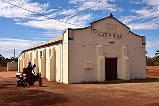
Gutha is a townsite in the Mid West region of Western Australia, 32 kilometres (20 mi) north of Morawa.
Mount Morgans, known as Mount Morgan until 1899, is an abandoned town in Western Australia 900 kilometres (559 mi) northeast of Perth and 40 kilometres (25 mi) southwest of Laverton on the original Malcolm-Laverton Road, in the Goldfields-Esperance region of Western Australia.
Mount Margaret was an abandoned town located 900 kilometres (559 mi) northeast of Perth and 31 kilometres (19 mi) southwest of Laverton in the Goldfields-Esperance region of Western Australia.
Boolading is a location along the Coalfields Highway between Darkan and Collie in the Wheatbelt region of Western Australia.
Kunanalling is an abandoned town in Western Australia located between Coolgardie and Balgarri along the Coolgardie North Road in the Goldfields-Esperance region of Western Australia. It is located in the Shire of Coolgardie.
Mulgarrie is a ghost town, located between Kalgoorlie and Leonora in the Shire of Menzies in the Goldfields-Esperance region of Western Australia.
Sir Samuel is an abandoned town located between Leinster and Wiluna in the Goldfields-Esperance region of Western Australia.
Mayanup is a small town in the South West region of Western Australia. It is between Boyup Brook and Kojonup. At the 2006 census, Mayanup had a population of 323.

Wialki is a townsite in the eastern Wheatbelt region of Western Australia. It is situated between Beacon and Bonnie Rock, in the shires of Mount Marshall and Mukinbudin.
Linden is an abandoned town located in the Goldfields-Esperance region in Western Australia. It is found between Kalgoorlie and Laverton near the southern edge of Lake Carey.
Niagara is an abandoned town located in the Goldfields-Esperance region in Western Australia, between Kalgoorlie and Leonora, 12 kilometres (7.5 mi) southwest of Kookynie.
Yarri is an abandoned town located in the Goldfields–Esperance region in Western Australia. It is located between Kalgoorlie and Laverton in the Shire of Menzies.
Yerilla is an abandoned town located in the Goldfields-Esperance region in Western Australia. It is found between Kalgoorlie and Laverton.


