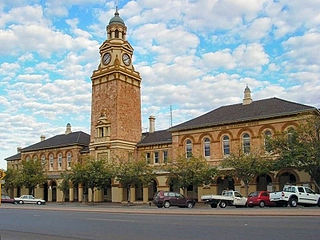
Kalgoorlie is a city in the Goldfields–Esperance region of Western Australia, located 595 km (370 mi) east-northeast of Perth at the end of the Great Eastern Highway. It is sometimes referred to as Kalgoorlie–Boulder, as the surrounding urban area includes the historic townsite of Boulder and the local government area is the City of Kalgoorlie–Boulder.

Heirisson Island is an island in the Swan River in Western Australia at the eastern end of Perth Water, between the suburbs of East Perth and Victoria Park. It occupies an area of 285600 m2, and is connected to the two foreshores by The Causeway. The next upstream island is Kuljak Island, then Ron Courtney Island, with no islands in the Swan River downstream between Heirisson Island and the Indian Ocean other than the artificial islet in Elizabeth Quay.

Warnervale is a town in the Central Coast Council local government area in the Central Coast region in the state of New South Wales, Australia. It lies approximately 101 km north of Sydney, located west of Tuggerah Lake, a large shallow coastal lake, and just north of Wyong.

The Sydney central business district (CBD) is the historical and main commercial centre of Sydney. The CBD is Sydney's city centre, or Sydney City, and the two terms are used interchangeably. Colloquially, the CBD or city centre is often referred to simply as "Town" or "the City". The Sydney city centre extends southwards for about 3 km (2 mi) from Sydney Cove, the point of first European settlement in which the Sydney region was initially established.
Parkeston is a suburb of the city of Kalgoorlie, Western Australia, located 3 kilometres (1.9 mi) east of the city centre. At the 2016 census, it had a population of 60, down from 69 in 2006. It contains the Ninga Mia Aboriginal community.

Doodlakine is a town 220 km (140 mi) east of Perth, Western Australia. It is within the Shire of Kellerberrin along the Great Eastern Highway. The town has a crossing loop for trains on the Perth-to-Kalgoorlie railway and serves as a stop on the MerredinLink rural train service.
Yellowdine is a town located 402 kilometres (250 mi) east of Perth, Western Australia on the Great Eastern Highway. The townsite is in the Goldfields-Esperance region, situated in the Shire of Yilgarn.
Edmondson Park is a suburb in the South West of Sydney, in the state of New South Wales, Australia. Edmondson Park is located 32 kilometres from the Sydney central business district, in the local government area of the City of Liverpool.

Boulder is a suburb of Kalgoorlie in the Western Australian Goldfields, 597 kilometres (371 mi) east of Perth.

Cullacabardee is a northeastern rural suburb of Perth, the capital city of Western Australia, located 21 km (13 mi) from Perth's central business district via Alexander Drive or Beechboro Road. It is in the City of Swan local government area. Most of the suburb is covered in native sheoak and banksia forest. A small Noongar community is based on Baal Street, a drug rehabilitation retreat is located off Gnangara Road in the suburb's northeast, and the Perth International Telecommunications Centre facility is based in the suburb's northwest.

Kalgoorlie-Boulder Airport is an airport in Kalgoorlie, Western Australia. The airport is 3 nautical miles south of the city. The airport handled 299,055 passengers in the 2021–22 financial year.

The City of Kalgoorlie–Boulder is a local government area in the Goldfields–Esperance region of Western Australia, about 550 kilometres (342 mi) east of the state capital, Perth. Covering an area of 95,575 square kilometres (36,902 sq mi), the city is the 12th largest in the world, larger than the country of Portugal with a land area of 92,212 square kilometres (35,603 sq mi). Its seat of government is the town of Kalgoorlie; all but 244 of the city's population live in either Kalgoorlie or Boulder.
Bulong is an abandoned town in Western Australia located 580 kilometres (360 mi) east of Perth in the Goldfields-Esperance region of Western Australia.
Kurnalpi is an abandoned town in the Goldfields-Esperance region of Western Australia. It lies in what was once Maduwongga territory and is situated about 60 km north-east of Kalgoorlie.
Victory Heights is a residential suburb of Kalgoorlie-Boulder, a city in the Eastern Goldfields region of Western Australia. At the 2016 census it had a population of 893 people, down from 908 at the 2011 census.
Karlkurla is a locality in the Eastern Goldfields region of Western Australia. It is a suburb of Kalgoorlie-Boulder. At the 2016 census, Karlkurla had a population of 177 people, up from 42 in 2011. The names of Karlkurla and Kalgoorlie are derived from the same root, the local Aboriginal word for the silky pear.

Mullingar is a locality in the Eastern Goldfields region of Western Australia. It is a suburb of Kalgoorlie-Boulder. At the 2016 census, Mullingar had a population of 305 people, down from 343 in 2011.
Hannans is a residential suburb of Kalgoorlie-Boulder, a city in the Eastern Goldfields region of Western Australia. At the 2016 census it had a population of 2,546 people, up from 2,483 in 2011. Hannans is named after Paddy Hannan, the prospector whose discovery of gold in 1893 led to the initial rush. The name Hannans originally referred to the Kalgoorlie townsite, and it was only much later in the city's history that it was applied to the current suburb.
Piccadilly is a residential suburb of Kalgoorlie-Boulder, a city in the Eastern Goldfields region of Western Australia. At the 2016 census, it had a population of 2,263 people, down from 2,597 in 2011.
West Kalgoorlie is an industrial suburb of Kalgoorlie-Boulder, a city in the Eastern Goldfields region of Western Australia.
