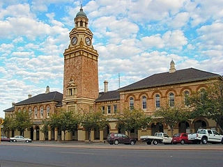
Kalgoorlie is a city in the Goldfields-Esperance region of Western Australia, located 595 km (370 mi) east-northeast of Perth at the end of the Great Eastern Highway. It is sometimes referred to as Kalgoorlie-Boulder, as the surrounding urban area includes the historic townsite of Boulder and the local government area is the City of Kalgoorlie-Boulder.

Kanowna is a ghost town in the Goldfields region of Western Australia, about 20 kilometres (12 mi) east of Kalgoorlie. It is sited on Maduwongga tribal lands. At the 2016 census, Kanowna had a population of 10 people.

The Eastern Suburbs is the metropolitan region directly to the east and south-east of the central business district in Sydney, New South Wales, Australia.
Parkeston is a suburb of the city of Kalgoorlie, Western Australia, located 3 km east of the city centre. At the 2016 census, it had a population of 60 people, down from 69 in 2006.

Canning Vale is a southern suburb of Perth, 16 km (9.9 mi) from the central business district. Its local government areas are the City of Canning and the City of Gosnells.
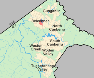
Belconnen is the most inner suburb of the larger district of Belconnen in Canberra, Australia. Sharing its name with the larger district which encapsulates it, the suburb is surrounded with well developed infrastructure, and planning which allows it sunset views from the Brindabellas on its western side. The suburb contains important amenities for the District of Belconnen including the Belconnen Town Centre and Lake Ginninderra as well as its own well populated residential areas. It is bounded by Ginninderra Drive, Aikman Drive, Eastern Valley Way, Belconnen Way and Coulter Drive. It has a number of parks such as Margaret Timpson Park, Eastern Valley Oval, and on the foreshores of Lake Ginninberra, Diddams Close Park and John Knight Memorial Park.

Bayview Heights is a southern suburb of Cairns in the Cairns Region, Queensland, Australia. In the 2016 census Bayview Heights had a population of 4,238 people.

Angle Park is a north-western suburb of Adelaide 10 km from the CBD, in the state of South Australia, Australia and falls under the City of Port Adelaide Enfield. It is adjacent to Wingfield, Mansfield Park, Ferryden Park, and Regency Park. The post code for Angle Park is 5010. It is bounded to the north by Grand Junction Road, west by Trafford Street, and to the east by Days Road and the North-South Motorway.

Athol Park is a north-western suburb of Adelaide, South Australia. It is located in the City of Charles Sturt.

Boulder is a suburb in the Western Australian Goldfields, 595 kilometres (370 mi) east of Perth and bordering onto the town of Kalgoorlie in the Eastern Goldfields region.

Seventeen Mile Rocks is a suburb in the City of Brisbane, Queensland, Australia. In the 2016 census, Seventeen Mile Rocks had a population of 2,720 people.

Rochedale is an outer southern suburb of the City of Brisbane, Queensland, Australia. It is 17 kilometres (11 mi) south-east of the Brisbane central business district. At the 2016 Australian Census the suburb recorded a population of 3,175. The suburb's western boundary is partially aligned with the Gateway Motorway and Bulimba Creek.

The City of Kalgoorlie-Boulder is a local government area in the Goldfields-Esperance region of Western Australia, about 550 kilometres (342 mi) east of the state capital, Perth. The City covers an area of 95,575 square kilometres (36,902 sq mi), and its seat of government is the town of Kalgoorlie; all but 244 of the city's population live in either Kalgoorlie or Boulder.
Kalgoorlie is the central suburb of the Kalgoorlie-Boulder metropolitan area in the Goldfields-Esperance region of Western Australia.

Prince Henry Heights is a residential locality on the outskirts of Toowoomba in the Toowoomba Region, Queensland, Australia. In the 2016 census, Prince Henry Heights had a population of 571 people.

Karlkurla is a locality in the Eastern Goldfields region of Western Australia. It is a suburb of Kalgoorlie-Boulder. At the 2016 census, Karlkurla had a population of 177 people, up from 42 in 2011. The names of Karlkurla and Kalgoorlie are derived from the same root, the local Aboriginal word for the silky pear.

Mullingar is a locality in the Eastern Goldfields region of Western Australia. It is a suburb of Kalgoorlie-Boulder. At the 2016 census, Mullingar had a population of 305 people, down from 343 in 2011.
Hannans is a residential suburb of Kalgoorlie-Boulder, a city in the Eastern Goldfields region of Western Australia. At the 2016 census it had a population of 2,546 people, up from 2,483 in 2011. Hannans is named after Paddy Hannan, the prospector whose discovery of gold in 1893 led to the initial rush. The name Hannans originally referred to the Kalgoorlie townsite, and it was only much later in the city's history that it was applied to the current suburb.
Piccadilly is a residential suburb of Kalgoorlie-Boulder, a city in the Eastern Goldfields region of Western Australia. At the 2016 census, it had a population of 2,263 people, down from 2,597 in 2011.
Lamington is a residential suburb of Kalgoorlie-Boulder, a city in the Eastern Goldfields region of Western Australia. It had a population of 2,112 people at the 2011 census, down from 2,278 in 2011.
