São Tomé and Príncipe is a small island country composed of an archipelago located in the Gulf of Guinea of the equatorial Atlantic Ocean. The nation's main islands are São Tomé Island and Príncipe Island, for which the country is named. These are located about 300 and 250 kilometres, respectively, off the northwest coast of Gabon in Central Africa.

These lists cover volcanoes by type and by location.

In mountaineering and climbing, a first ascent, is the first successful documented climb to the top of a mountain or the top of a particular climbing route. Early 20th-century mountaineers and climbers focused on reaching the tops of iconic mountains and climbing routes by whatever means possible, often using considerable amounts of aid climbing, and/or with large expedition style support teams that laid "siege" to the climb.

Pico de Orizaba, also known as Citlaltépetl, is an active volcano, the highest mountain in Mexico and third highest in North America, after Denali of United States and Mount Logan of Canada. Pico de Orizaba is also the highest volcano in North America. It rises 5,636 metres (18,491 ft) above sea level in the eastern end of the Trans-Mexican Volcanic Belt, on the border between the states of Veracruz and Puebla. The volcano is currently dormant but not extinct, with the last eruption taking place during the 19th century. It is the second most prominent volcanic peak in the world after Mount Kilimanjaro. Pico de Orizaba is ranked 16th by topographic isolation.

Shiprock is a monadnock rising nearly 1,583 feet (482 m) above the high-desert plain of the Navajo Nation in San Juan County, New Mexico, United States. Its peak elevation is 7,177 feet (2,188 m) above sea level. It is 10.75 miles (17.30 km) southwest of the town of Shiprock, which is named for the peak.

A volcanic plug, also called a volcanic neck or lava neck, is a volcanic object created when magma hardens within a vent on an active volcano. When present, a plug can cause an extreme build-up of high gas pressure if rising volatile-charged magma is trapped beneath it, and this can sometimes lead to an explosive eruption. In a plinian eruption the plug is destroyed and ash is ejected.

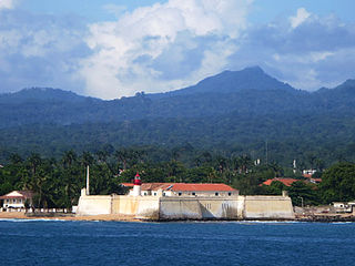
São Tomé Island, at 854 km2 (330 sq mi), is the largest island of São Tomé and Príncipe and is home in May 2018 to about 193,380 or 96% of the nation's population. The island is divided into six districts. It is located 2 km north of the Equator.
Pico de São Tomé is the highest mountain in São Tomé and Príncipe at 2,024 m (6,640 ft) elevation. It lies just west of the centre of São Tomé Island, in the Parque Natural Obô de São Tomé and in the Lembá District. The second highest point, Pico de Ana Chaves (1,630 m [5,348 ft]), lies about 3 km (1.9 mi) to its south east. The town Santa Catarina is 8 km (5.0 mi) to the west.

The Mandara Mountains are a volcanic range extending about 190 km along the northern part of the Cameroon–Nigeria border, from the Benue River in the south to the north-west of Maroua in the north. The highest elevation is the summit of Mount Oupay, at 1,494 m (4,900 ft) above sea level.

Agathla Peak or Agathlan is a peak south of Monument Valley, Arizona, which rises over 1,500 feet above the surrounding terrain. It is 7 miles (11 km) north of Kayenta and is visible from U.S. Route 163. The English designation Agathla is derived from the Navajo name aghaałą́ meaning 'much wool', apparently for the fur of antelope and deer accumulating on the rock. The mountain is considered sacred by the Navajo.

Pico Basilé, located on the island of Bioko, is the tallest mountain of Equatorial Guinea. With an elevation of 9,878 ft, it is the summit of the largest and highest of three overlapping basaltic shield volcanoes which form the island. From the summit, Mount Cameroon can be seen to the north-east. Pico Basilé lies close to the city of Malabo. The very top is used as a broadcast transmitting station for RTVGE and microwave relay station for various communication networks.

The Naranjo de Bulnes is a limestone peak dating from the Paleozoic Era, located in the Macizo Central region of the Picos de Europa, Asturias (Spain). Its name Picu Urriellu is believed to be derived from the term Los Urrieles, which is used to describe the Macizo Central. Naranjo de Bulnes is part of the Cabrales region of Asturias, and lies within the Picos de Europa National Park.
The Cameroon line is a 1,600 km (1,000 mi) long chain of volcanoes that includes islands in the Gulf of Guinea and mountains on the African mainland, from Mount Cameroon on the coast towards Lake Chad on the northeast. They form a natural border between eastern Nigeria and the West Region of Cameroon. The islands, which span the equator, have tropical climates and are home to many unique plant and bird species. The mainland mountain regions are much cooler than the surrounding lowlands, and also contain unique and ecologically important environments.

The São Tomé, Príncipe, and Annobón forests, also known as the São Tomé, Príncipe, and Annobón moist lowland forests, is a tropical moist broadleaf forest ecoregion that covers the islands of São Tomé and Príncipe, which form the island nation of São Tomé and Príncipe, as well as the island of Annobón, which is part of Equatorial Guinea.

The wildlife of São Tomé and Príncipe is composed of its flora and fauna. São Tomé and Príncipe are oceanic islands which have always been separate from mainland West Africa and so there is a relatively low diversity of species, restricted to those that have managed to cross the sea to the islands. However the level of endemism is high with many species occurring nowhere else in the world.
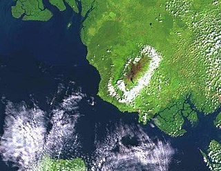
The Mount Cameroon and Bioko montane forests is a tropical moist broadleaf forest ecoregion in central Africa. It occupies the upper slopes of coastal Mount Cameroon in Cameroon, and the mountains of nearby Bioko island in Equatorial Guinea.
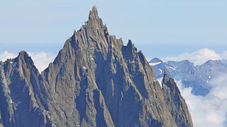
The Aiguille du Grépon, informally known as The Grepon, is a mountain in the Mont Blanc Massif in Haute-Savoie, France. The Grepon has a Southern and Northern peak, which are the highest points of a sharp granite ridge to the east of the Glacier des Nantillons above Chamonix and northeast of the Aiguille du Midi. A madonna statue is situated on the Southern peak.
Pico do Príncipe is a mountain on the island of Príncipe, the smaller of the two inhabited islands of São Tomé and Príncipe. The elevation of the mountain is 947 metres (3,107 ft), making it the highest peak on the island. The island is one of the volcanic swells that make up the Cameroon line of extinct and active volcanoes.
Vila Clotilde is a village in Caué District on São Tomé Island in São Tomé and Príncipe. Its population is 53. Vila Clotilde lies 6.5 km west of São João dos Angolares. 3 km to its west is Pico Cão Grande, an iconic needle-shaped volcanic plug.