
Newfoundland and Labrador is the easternmost province of Canada, in the country's Atlantic region. The province comprises the island of Newfoundland and the continental region of Labrador, having a total size of 405,212 km2 (156,453 sq mi) As of January 1, 2024, the population of Newfoundland and Labrador was estimated to be 541,391. The island of Newfoundland is home to around 94 per cent of the province's population, with more than half residing in the Avalon Peninsula. Labrador shares a land border with both the province of Quebec and the territory of Nunavut on Killiniq Island. The French overseas collectivity of Saint Pierre and Miquelon lies about 20 km (12 mi) west of the Burin Peninsula.

Saint Pierre and Miquelon, officially the Overseas Collectivity of Saint-Pierre and Miquelon, is a self-governing territorial overseas collectivity of France in the northwestern Atlantic Ocean, located near the Canadian province of Newfoundland and Labrador. An archipelago of eight islands, St. Pierre and Miquelon is a vestige of the once-vast territory of New France. Its residents are French citizens. The collectivity elects its own deputy to the National Assembly and participates in senatorial and presidential elections. It covers 242 km2 (93 sq mi) of land and had a population of 6,008 as of the March 2016 census.
The flag of Newfoundland and Labrador was introduced in 1980 and was designed by Newfoundland artist Christopher Pratt. The flag design was approved by the House of Assembly of the province of Newfoundland, Canada, on May 28, 1980. It was flown for the first time on Discovery Day, June 24, 1980. The name of the province was changed to Newfoundland and Labrador by an amendment to the constitution of Canada in December 2001 at the request of the provincial legislature.

The Grand Banks of Newfoundland are a series of underwater plateaus south-east of the island of Newfoundland on the North American continental shelf. The Grand Banks are one of the world's richest fishing grounds, supporting Atlantic cod, swordfish, haddock and capelin, as well as shellfish, seabirds and sea mammals.

Events from the year 1830 in Canada.

The Pierinae are a large subfamily of pierid butterflies. The subfamily is one of several clades of butterflies often referred to as the whites.
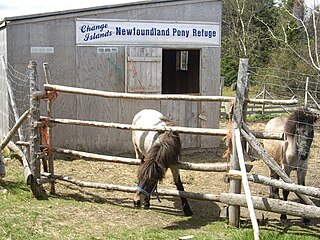
The Newfoundland pony is a breed of pony originating in Newfoundland, Canada. They are sturdy and muscular ponies, found in many colors, including the relatively rare white coloration. The Newfoundland developed from a mix of English, Irish, and Scottish pony breeds brought to Newfoundland by settlers over a period of four centuries. Initially free-roaming, they crossbred to produce the modern type. They were used by settlers as draft and multi-purpose ponies until the mid-20th century century, when they were brought almost to the point of extinction by mechanization and slaughter. The population rebounded slightly after the formation of a breed registry in 1980, but still remains low. In 1997, the Newfoundland pony was declared a heritage breed of Newfoundland and Labrador, which afforded it protection under the law, but the breed has not yet been recognized under the Canadian federal Animal Pedigree Act. As of 2008, there were 248 registered ponies of breeding age, out of a total population of 361. In 2013, the widely dispersed breeding population is still estimated at between 200 and 250 animals.
The Maritime Archaic is a North American cultural complex of the Late Archaic along the coast of Newfoundland, the Canadian Maritimes and northern New England. The Maritime Archaic began in approximately 7000 BC and lasted until approximately 3500 BC, corresponding with the arrival of the Paleo-Eskimo groups who may have outcompeted the Maritime Archaic for resources. The culture consisted of sea-mammal hunters in the subarctic who used wooden boats. Maritime Archaic sites have been found as far south as Maine and as far north as Labrador. Their settlements included longhouses, and boat-topped temporary or seasonal houses. They engaged in long-distance trade, as shown by white Ramah chert from northern Labrador being found as far south as Maine.
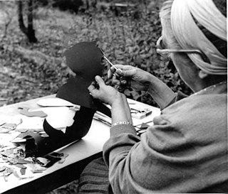
Silhouette animation is animation in which the characters are only visible as black silhouettes. This is usually accomplished by backlighting articulated cardboard cut-outs, though other methods exist. It is partially inspired by, but for a number of reasons technically distinct from, shadow play.

Reidville is a village located north east of Deer Lake. A post office was established in 1967 and the first Postmisstress was Dorothy Barrett.

Point May is the most southerly community on the Burin Peninsula in Newfoundland and Labrador with a population of 254 in 2021. It is a Catholic community with a church, town hall, fire hall, softball and soccer field. It is known for its close proximity, 19 km (12 mi), to the French islands of St. Pierre and Miquelon, where the smuggling of liquor and tobacco has been a way of life since before Canada was a country. The tiny Canadian Green Island lies 10 km (6 mi) west of Point May, roughly halfway to St. Pierre.

L'Oiseau Blanc was a French Levasseur PL.8 biplane that disappeared in 1927 during an attempt to make the first non-stop transatlantic flight between Paris and New York City to compete for the Orteig Prize. French World War I aviation heroes Charles Nungesser and François Coli took off from Paris on 8 May 1927 and were last seen over Ireland. Less than two weeks later, Charles Lindbergh successfully made the New York–Paris journey and claimed the prize in the Spirit of St. Louis.
An insectarium is a live insect zoo, or a museum or exhibit of live insects. Insectariums often display a variety of insects and similar arthropods, such as spiders, beetles, cockroaches, ants, bees, millipedes, centipedes, crickets, grasshoppers, stick insects, scorpions, mantises and woodlice. Displays can focus on learning about insects, types of insects, their habitats, why they are important, and the work of entomologists, arachnologists, and other scientists that study terrestrial arthropods and similar animals.
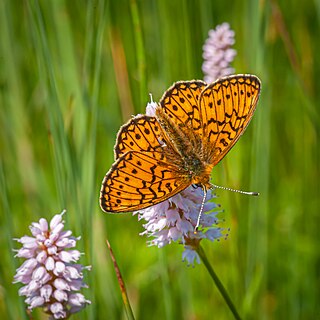
Boloria eunomia, the bog fritillary or ocellate bog fritillary is a butterfly of the family Nymphalidae.

Papilio canadensis, the Canadian tiger swallowtail, is a species of butterfly in the family Papilionidae. It was once classified as a subspecies of Papilio glaucus.

Oeneis jutta, the Jutta Arctic or Baltic grayling, is a species of butterfly in the subfamily Satyrinae with a Circumboreal distribution. It occurs in bogs and tundra in the north of Europe, the Baltic states, the Urals, Siberia, northern Kazakhstan, the Russian Far East, northern Mongolia, northeastern China, North Korea, and northern North America. Larvae feed on Carex and Eriophorum, possibly also Glyceria, Molinia, and Juncus. Ledum palustre is the preferred nectar plant of the adult butterflies. The species has one generation every one or two years, depending on the location.

Franco-Newfoundlanders, also known as Franco-Terreneuvians in English or Franco-Terreneuviens in French, are francophone and/or French Canadian residents of the Canadian province of Newfoundland and Labrador. The name Franco-Terreneuvian derives from Terre-Neuve, the French name of Newfoundland.
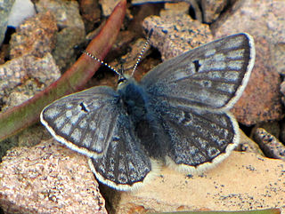
Agriades glandon, the Arctic blue or Glandon blue, is a species of butterfly in the family Lycaenidae. It in found in Eurasia and North America.
Oeneis polixenes, the Polixenes Arctic or Norique Alpin, is a species of butterfly in the subfamily Satyrinae. It has a Circumpolar distribution occurring in northern parts of North America the Arctic Urals, Kamtchatka, Yakutia, Chukchi Peninsula, and northern Siberia.
Les Princes et la Princesse de Marinca is a French-Canadian fairy tale from Gaspésie published by Canadian folklorist Carmen Roy. It is related to the motif of the calumniated wife and classified in the international Aarne-Thompson-Uther Index as type ATU 707, "The Three Golden Children".