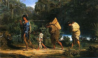
The Choctaw are a Native American people originally based in the Southeastern Woodlands, in what is now Alabama and Mississippi. Their Choctaw language is a Western Muskogean language. Today, Choctaw people are enrolled in three federally recognized tribes: the Choctaw Nation of Oklahoma, Mississippi Band of Choctaw Indians, and Jena Band of Choctaw Indians in Louisiana.
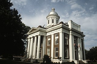
Madison County is a county located in the U.S. state of Mississippi. As of the 2020 census, the population was 109,145. The county seat is Canton. The county is named for U.S. President James Madison.

The Natchez Trace, also known as the Old Natchez Trace, is a historic forest trail within the United States which extends roughly 440 miles (710 km) from Nashville, Tennessee, to Natchez, Mississippi, linking the Cumberland, Tennessee, and Mississippi rivers.

The Natchez Trace Parkway is a national parkway in the southeastern United States that commemorates the historic Natchez Trace and preserves sections of that original trail. Its central feature is a two-lane road that extends 444 miles (715 km) from Natchez, Mississippi, to Nashville, Tennessee. Access to the parkway is limited, with more than fifty access points in the states of Mississippi, Alabama, and Tennessee. The southern end of the route is in Natchez at its intersection with Liberty Road, and the northern end is northeast of Fairview, Tennessee, in the suburban community of Pasquo, at an intersection with Tennessee State Route 100. In addition to Natchez and Nashville, larger cities along the route include Jackson and Tupelo, Mississippi, and Florence, Alabama.
The Little Buffalo River is an 18.1-mile-long (29.1 km) tributary of the Buffalo River in the U.S. state of Tennessee. Via the Buffalo, Duck, Tennessee, and Ohio rivers, it reaches the Mississippi River.

Tishomingo State Park is a public recreation area located in the foothills of the Appalachian Mountains in Tishomingo County, some 45 miles (72 km) northeast of Tupelo, Mississippi. The major feature of the park is Bear Creek Canyon and its generous sandstone outcroppings. Activities in the park include canoeing, rock climbing, fishing, and hiking. The park sits at Milepost 304 of Natchez Trace Parkway, a scenic road operated by the National Park Service commemorating the historical Natchez Trace.
Eagletown is an unincorporated community and census-designated place in McCurtain County, Oklahoma, United States. The population was 528 at the 2010 census. Located on Mountain Fork River, approximately 6 miles (9.7 km) from the Oklahoma-Arkansas border, it was the first permanent Choctaw settlement in the Indian Territory, who called it osi yamaha ("Eagle"). Eagletown was an important town from 1834 to 1906, and after 1850, served as county seat for the Choctaw Nation's Eagle County. The town name was officially changed to "Eagle Town" in 1850, then changed to the present Eagletown in 1892. When Indian Territory was preparing to unite with Oklahoma Territory to form the new state of Oklahoma in 1906, Eagletown lost its county seat status and became just another unincorporated community in the new McCurtain County.
The Yockanookany River is a 78.4-mile-long (126.2 km) river in central Mississippi in the United States. It is a tributary of the Pearl River, which flows to the Gulf of Mexico.

Tuskahoma is an unincorporated community and census-designated place in northern Pushmataha County, Oklahoma, United States, four miles east of Clayton. It was the former seat of the Choctaw Nation government prior to Oklahoma statehood. The population at the 2010 census was 151.

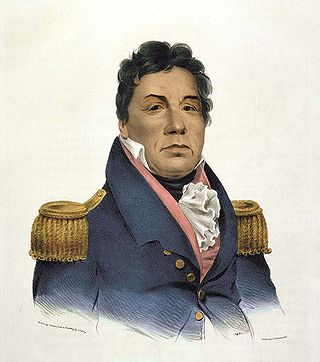
Mushulatubbee was the chief of the Choctaw Okla Tannap, one of the three major Choctaw divisions during the early 19th century. When the Principal Chief Greenwood LeFlore stayed in Mississippi at the time of removal, Mushulatubbee was elected as principal chief, leading the tribe to Indian Territory.

LeFleur's Bluff State Park is a public recreation area located on the banks of the Pearl River off Interstate 55 within the city limits of Jackson, Mississippi. The state park is home to a 50-acre (20 ha) lake, a 9-hole golf course, and the Mississippi Museum of Natural Science.
Pushmataha, the "Indian General", was one of the three regional chiefs of the major divisions of the Choctaw in the 19th century. Many historians considered him the "greatest of all Choctaw chiefs". Pushmataha was highly regarded among Native Americans, Europeans, and white Americans, for his skill and cunning in both war and diplomacy.
Levi Colbert (1759–1834), also known as Itawamba in Chickasaw, was a leader and chief of the Chickasaw nation. Colbert was called Itte-wamba Mingo, meaning bench chief. He and his brother George Colbert were prominent interpreters and negotiators with United States negotiators in the early decades of the 19th century. They were appointed by President Andrew Jackson's administration to gain cession of their lands and arrange for removal of their people to Indian Territory west of the Mississippi River. They were under considerable pressure from the Mississippi state government, white interlopers in their area, and the federal government to cede their lands.

Peter Perkins Pitchlynn was a Choctaw chief of Choctaw and Anglo-American ancestry. He was principal chief of the Choctaw Republic from 1864-1866 and surrendered to the Union on behalf of the nation at the end of the Civil War.

The Treaty of Washington City was a treaty signed on January 20, 1825 between the Choctaw and the United States Government.
Apuckshunubbee was one of three principal chiefs of the Choctaw Native American tribe in the early nineteenth century, from before 1800. He led the western or Okla Falaya District of the Choctaw, of which the eastern edge ran roughly southeast from modern Winston County to Lauderdale County, then roughly southwest to Scott County, then roughly south-southeast to the western edge of Perry County. His contemporaries were Pushmataha and Moshulatubbee, who respectively led the southern district Okla Hannali and the north-eastern district Okla Tannap.

Buzzard Roost is an unincorporated community in Colbert County, Alabama. Buzzard Roost had a post office in the 1850s, but it no longer exists.

Fly is an unincorporated community in Maury County, Tennessee. It is along the Natchez Trace Parkway, south of Nashville. The small valley known as Fly Hollow is between Fly and the Natchez Trace.
Seven segments of the historic Natchez Trace are listed on the National Register of Historic Places (NRHP). Also there are additional NRHP-listed structures and other sites along the Natchez Trace, which served the travelers of the trace and survive from the era of its active use.
Uniontown is a ghost town in Jefferson County, Mississippi, United States.


