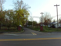
French Camp, Mississippi | |
---|---|
Coordinates: 33°17′38″N89°24′1″W / 33.29389°N 89.40028°W | |
Country | United States |
State | Mississippi |
County | Choctaw |
Government | |
• Mayor | Glen Barlow |
• Alderman | Dennis Cates |
• Alderwoman | Jenny Morgan |
• Alderman | Phil Nicholson |
• Alderwoman | Becky Stephens |
Area | |
• Total | 0.99 sq mi (2.56 km2) |
• Land | 0.98 sq mi (2.54 km2) |
• Water | 0.01 sq mi (0.02 km2) |
Elevation | 413 ft (126 m) |
Population (2020) | |
• Total | 256 |
• Density | 260.96/sq mi (100.76/km2) |
Time zone | UTC-6 (Central (CST)) |
• Summer (DST) | UTC-5 (CDT) |
ZIP code | 39745 |
Area code | 662 |
FIPS code | 28-26020 |
GNIS feature ID | 0670200 |
French Camp is a town in Choctaw County, Mississippi, United States. The population was 174 at the 2010 census, [2] down from 393 in 2000.
The town dates back to circa 1810, when a Frenchman, Louis Lefleur, established a stand or trading post and inn, on the Natchez Trace. The Choctaw natives and others in the area called it the Frenchman's Camp. Later it was shortened to French Camp. [3]
French Camp is located in western Choctaw County at 33°17′38″N89°24′1″W / 33.29389°N 89.40028°W (33.293936, -89.400248). [4] It is bordered to the south by Attala County. The Natchez Trace Parkway passes through the town, crossing Mississippi Highway 413 just west of the center of town.
According to the United States Census Bureau, the town has a total area of 1.0 square mile (2.6 km2), of which 0.0077 square miles (0.02 km2), or 0.81%, is water. [2]
Census | Pop. | Note | %± |
---|---|---|---|
1880 | 420 | — | |
1890 | 267 | −36.4% | |
1900 | 259 | −3.0% | |
1910 | 220 | −15.1% | |
1920 | 123 | −44.1% | |
1930 | 181 | 47.2% | |
1940 | 172 | −5.0% | |
1950 | 162 | −5.8% | |
1960 | 123 | −24.1% | |
1970 | 174 | 41.5% | |
1980 | 306 | 75.9% | |
1990 | 320 | 4.6% | |
2000 | 393 | 22.8% | |
2010 | 174 | −55.7% | |
2020 | 256 | 47.1% | |
U.S. Decennial Census [5] |
As of the census [6] of 2000, there were 393 people, 68 households, and 42 families residing in the town. The population density was 398.1 inhabitants per square mile (153.7/km2). There were 74 housing units at an average density of 75.0 per square mile (29.0/km2). The racial makeup of the town was 92.37% White, 5.09% African American, 1.53% from other races, and 1.02% from two or more races. Hispanic or Latino of any race were 1.27% of the population.
There were 68 households, out of which 26.5% had children under the age of 18 living with them, 54.4% were married couples living together, 4.4% had a female householder with no husband present, and 36.8% were non-families. 36.8% of all households were made up of individuals, and 17.6% had someone living alone who was 65 years of age or older. The average household size was 2.43 and the average family size was 3.19.
In the town, the population was spread out, with 48.6% under the age of 18, 9.4% from 18 to 24, 13.5% from 25 to 44, 16.5% from 45 to 64, and 12.0% who were 65 years of age or older. The median age was 18 years. For every 100 females, there were 113.6 males. For every 100 females age 18 and over, there were 96.1 males.
The median income for a household in the town was $26,250, and the median income for a family was $27,188. Males had a median income of $13,750 versus $12,813 for females. The per capita income for the town was $5,047. (The lowest in Mississippi) About 17.1% of families and 64.5% of the population were below the poverty line, including 70.5% of those under age 18 and none of those age 65 or over.
The United States Postal Service operates the French Camp Post Office. [7]
The town of French Camp is served by the Choctaw County School District and the private French Camp Academy.
Hardeman County is a county located in the U.S. state of Tennessee. As of the 2020 census, the population was 25,462. Its county seat is Bolivar.
Winston County is a county located in the U.S. state of Mississippi. In the 2020 census, the population was 17,714. Its county seat is Louisville. The county is named for Louis Winston (1784–1824), a colonel in the militia, a prominent lawyer, and a judge of the Mississippi Supreme Court.
Webster County is a county located in center of the U.S. state of Mississippi, bordered on the south by the Big Black River. As of the 2020 census, the population was 9,926.
Pontotoc County is a county located in the U.S. state of Mississippi. As of the 2020 census, the population was 31,184. Its county seat is Pontotoc. It was created on February 9, 1836, from lands ceded to the United States under the Chickasaw Cession. Pontotoc is a Chickasaw word meaning "land of hanging grapes". The original Natchez Trace and the current-day Natchez Trace Parkway both pass through the southeast corner of Pontotoc County.
Newton County is a county located in the U.S. state of Mississippi. As of the 2020 census, the population was 21,291. Its county seat is Decatur.
Neshoba County is a county located in the central part of the U.S. state of Mississippi. As of the 2020 census, the population was 29,087. Its county seat is Philadelphia.
Madison County is a county located in the U.S. state of Mississippi. As of the 2020 census, the population was 109,145. The county seat is Canton. The county is named for Founding Father and U.S. President James Madison.
Leake County is a county in the center of the U.S. state of Mississippi. As of the 2020 census, the population was 21,275. Its county seat is Carthage. The county is named for Walter Leake, the Governor of Mississippi from 1822 to 1825.
Choctaw County is a county located in the central part of the U.S. state of Mississippi. As of the 2020 census, the population was 8,246. Its northern border is the Big Black River, which flows southwest into the Mississippi River south of Vicksburg. The county seat is Ackerman.
Attala County is a county located in the U.S. state of Mississippi. As of the 2020 census, the population was 17,889. Its county seat is Kosciusko. Attala County is named for Atala, a fictional Native American heroine from an early-19th-century novel of the same name by François-René de Chateaubriand.
Amite City is a town in and the seat of Tangipahoa Parish in southeastern Louisiana, United States. The population was 4,141 at the 2010 census. It is part of the Hammond Micropolitan Statistical Area.
Weir is a town in Choctaw County, Mississippi, United States. The population was 459 at the 2010 census, down from 553 at the 2000 census.
Redwater is a census-designated place (CDP) in Leake County, Mississippi, United States. It is one of the eight communities of the Mississippi Band of Choctaw Indians Reservation, and the population is 61% Choctaw. The population was 633 at the 2010 census, up from 409 at the 2000 census.
Standing Pine is a census-designated place (CDP) in Leake County, Mississippi, United States. It is one of the eight communities of the Mississippi Band of Choctaw Indians Reservation, and the population is 94% Choctaw. The total population of the CDP was 517 at the 2020 census.
Itta Bena is a city in Leflore County, Mississippi, United States. The population was 2,049 at the 2010 census. The town's name is derived from the Choctaw phrase iti bina, meaning "forest camp". Itta Bena is part of the Greenwood, Mississippi micropolitan area. It developed as a trading center of an area of cotton plantations.
Pearl River is a census-designated place (CDP) in Neshoba County, Mississippi. It is one of the eight communities of the Mississippi Band of Choctaw Indians Reservation and the population is 80% Choctaw. The population was 3,156 at the 2000 census.
Tucker is a census-designated place (CDP) in Neshoba County, Mississippi. It is one of the eight communities of the Mississippi Band of Choctaw Indians Reservation and the population is 93% Choctaw. The population was 642 at the 2020 census.
Conehatta is a census-designated place (CDP) in Newton County, Mississippi. The population was 997 at the 2000 census. It is one of the eight communities included in the Mississippi Band of Choctaw Indians Reservation and the population is 76% Choctaw.
Mathiston is a town in Choctaw and Webster counties, Mississippi. The population was 698 at the 2010 census.
Bogue Chitto is a census-designated place (CDP) situated in Kemper and Neshoba counties, Mississippi. The population was 864 at the 2020 census. It is part of the Mississippi Band of Choctaw Indians Reservation and the population is 93% Choctaw.