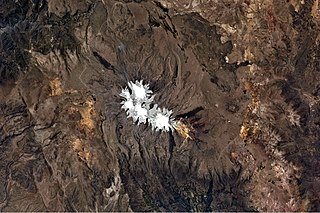
Huayruro Punco is a mountain in the Vilcanota mountain range in the Andes of Peru, about 5,550 metres (18,209 ft) high. It is situated in the Cusco Region, Canchis Province, Pitumarca District. Huayruro Punco lies southeast of Callangate, southwest of Chumpe and north of Cóndor Tuco and Comercocha, between the Chillcamayu which originates near Huayruro Punco and the lake named Sibinacocha.
Choquesafra or Choquezafra is a 5,152-metre-high (16,903 ft) mountain in the Vilcabamba mountain range in the Andes of Peru. It is located in the Cusco Region, La Convención Province, on the border of the districts of Inkawasi and Vilcabamba. Choquesafra lies west of the Panta group and south of a river named Rancahuayco. The Huajchay River originates northwest of the mountain. It flows to the southwest as a right affluent of the Apurímac River.

Millo is a mountain in the Vilcanota mountain range in the Andes of Peru, about 5,500 metres (18,045 ft) high. It is situated in the Cusco Region, Canchis Province, Checacupe District, and in the Puno Region, Carabaya Province, Corani District. Millo lies northwest of the large glaciated area of Quelccaya and west of Unollocsina.
Waqrawiri or Waxra Wiri is a mountain in the Wansu mountain range in the Andes of Peru, about 5,425 metres (17,799 ft) high. It is situated in the Arequipa Region, Castilla Province, Orcopampa District. Waqrawiri lies northwest of the lake Machuqucha and south of the river Millumayu.

Choquepirhua is a mountain in the Chila mountain range in the Andes of Peru, about 5,400 metres (17,717 ft) high. It lies in the Arequipa Region, Castilla Province, on the border of the districts of Chachas and Choco. Choquepirhua is situated south of Chila.
Chuquiananta is a mountain in the Andes of southern Peru, about 5,300 metres (17,388 ft) high. It is situated in the Moquegua Region, Mariscal Nieto Province, Torata District, and in the Tacna Region, Candarave Province, Camilaca District. Chuquiananta lies south-west of Tutupaca volcano, south-east of Pomani.
Qullpa is a mountain in the Wansu mountain range in the Andes of Peru, about 5,100 metres (16,732 ft) high. It is situated in the Arequipa Region, La Unión Province, Puyca District, and in the Cusco Region, Chumbivilcas Province, Santo Tomás District. It lies northwest of the mountains Qullpa K'uchu and Minasniyuq.

P'isqi P'isqi is a mountain in the Andes of Peru, about 4,600 metres (15,092 ft) high. It lies in the Arequipa Region, Castilla Province, Andagua District. P'isqi P'isqi is situated west of Wakapallqa and Llallawi.
Huancane Apacheta is a mountain in the Vilcanota mountain range in the Andes of Peru, about 5,200 metres (17,060 ft) high. It is located in the Cusco Region, Canchis Province, Checacupe District, and in the Puno Region, Carabaya Province, Corani District. Huancane Apacheta lies between the mountain Otoroncane in the northeast and Tutallipina and Sayrecucho in the southwest.
Chuqi Pirwa is a mountain in the Andes of Peru, about 5,200 m (17,100 ft) high. It is situated in the Cusco Region, Espinar Province, Condoroma District, and in the Puno Region, Lampa Province, Ocuviri District. Chuqi Pirwa lies southwest of Sawanani Lake (Saguanani) and northwest of Qullqi Q'awa.
Hatun Qurini is a mountain in the Peruvian Andes, about 5,000 metres (16,404 ft) high. It is situated in the Puno Region, Azángaro Province, San José District. Hatun Qurini lies northwest of the mountain Surupana.

Cuncapata is a mountain in the Vilcanota mountain range in the Andes of Peru, about 5,400 metres (17,717 ft) high. It is located in the Cusco Region, Canchis Province, Pitumarca District. Cuncapata lies southwest of the mountain Jatunñaño Punta, north of the lake Sibinacocha and southeast of Chumpe.
Pajo (possibly from Aymara for light brown, reddish, or ' is a mountain in the Vilcanota mountain range in the Andes of Peru, about 5,400 metres high. It is located in the Cusco Region, Canchis Province, Pitumarca District, northwest of Sibinacocha. It lies north of the peak of Uchuy Milla, northeast of Huayruro Punco and southeast of Osjollo Anante and Japu Japu. East of Pajo there is a valley with an intermittent stream named Puca orco. Its waters flow to Sibinacocha.
Sullu Sullu is a mountain in the Wansu mountain range in the Andes of Peru, about 5,100 metres (16,732 ft) high. It is situated in the Cusco Region, Chumbivilcas Province, Santo Tomás District. Sullu Sullu lies south of Sara Sara and northeast of Ikma.
Pisquioc is a mountain in the Vilcanota mountain range in the Andes of Peru, about 5,000 m (16,000 ft) high. It is located in the Cusco Region, Quispicanchi Province, Marcapata District, south of Aquichua.
Huarisallana is a mountain in the Vilcanota mountain range in the Andes of Peru, about 5,000 m (16,000 ft) high. It is located in the Cusco Region, Canchis Province, Checacupe District. Huarisallana lies near the Sequeñamayu valley, south of Intijahuana.
Machu Apachita is a mountain in the Andes of Peru, about 4,800 m (15,700 ft) high. It is located in the Cusco Region, Quispicanchi Province, on the border of the districts of Camanti and Marcapata. It is situated southeast of Wisk'achani.
Chaka Apachita is a 5,136-metre-high (16,850 ft) mountain in the Andes of Peru. It is situated in the Moquegua Region, Mariscal Nieto Province, Carumas District. It lies northwest of Qiwña Milluku and southeast of Qina Qinani.
Chuqi Pirwa is a mountain in the Andes of Peru, about 4,800 m (15,700 ft) high. It is located in the Arequipa Region, Caylloma Province, Tisco District, and in the Espinar Province, Yauri District. It lies northeast of Jañuma Pirwa and east of Pirwa.
Wanu Wanu is a mountain in the Andes of Peru, about 4,800 m (15,700 ft) high. It is located in the Cusco Region, Espinar Province, on the border of the districts of Condoroma and Ocoruro. It lies northeast of Atawallpa and southeast of Hatun Chhuka.


