Pioneer, Tennessee

Last updated

Pioneer, Tennessee
Pioneer-Baptist-Church-tn1.jpg
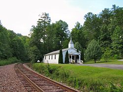
Pioneer Baptist Church
USA Tennessee location map.svg
Red pog.svg
Pioneer, Tennessee
Usa edcp location map.svg
Red pog.svg
Pioneer, Tennessee
Coordinates: 36°25′03″N84°18′51″W / 36.41750°N 84.31417°W / 36.41750; -84.31417
Country United States
State Tennessee
County Campbell
Elevation
1,549 ft (472 m)
Time zone UTC-5 (Eastern (EST))
  Summer (DST) UTC-4 (EDT)
ZIP code
37847 [1]
Area code 423
GNIS feature ID1297689 [2]

Pioneer is an unincorporated community in Campbell County, Tennessee, United States. [2] Its ZIP code is 37847. [3] It is situated in the upper Cove Creek Valley at the intersection of Tennessee State Route 297 and Tennessee State Route 63.

Notes

  1. "Zip Code 37847 Map and Profile". zipdatamaps.com. 2022. Retrieved November 1, 2022.
  2. 1 2 "Pioneer, Tennessee". Geographic Names Information System . United States Geological Survey, United States Department of the Interior.
  3. United States Postal Service (2012). "USPS - Look Up a ZIP Code" . Retrieved February 15, 2012.


Related Research Articles

<span class="mw-page-title-main">ZIP Code</span> Numeric postal code used in the United States and its territories

A ZIP Code is a system of postal codes used by the United States Postal Service (USPS). The term ZIP was chosen to suggest that the mail travels more efficiently and quickly when senders use the code in the postal address.

<span class="mw-page-title-main">Atoka, Tennessee</span> Town

Atoka is a local government area with a town charter in Tipton County, Tennessee, United States. In 1888, Atoka was a stop on the Newport News & Mississippi Valley Railroad. Today the City of New Orleans Amtrak passenger train makes its daily route between New Orleans and Chicago, through Atoka. The population was 10,008 at the 2020 census, making the Town of Atoka the largest municipality in Tipton County.

<span class="mw-page-title-main">Petros, Tennessee</span> Census-designated place in Tennessee, United States

Petros is an unincorporated community and census-designated place (CDP) in Morgan County, Tennessee, United States, located on State Route 116. Its population was 583 as of the 2010 Census. Petros has its own post office, with the ZIP code 37845.

<span class="mw-page-title-main">Dixon Springs, Tennessee</span> Unincorporated community in Tennessee, United States

Dixon Springs is an unincorporated community in Smith County, Tennessee, United States. It is located along Tennessee State Route 25 between Carthage and Hartsville. Dixon Springs has a post office, with zip code 37057.

Delano is an unincorporated community in Polk County, Tennessee, United States. It is located near the junction of U.S. Route 411, Tennessee State Route 30 and Tennessee State Route 163 4.3 miles (6.9 km) south-southwest of Etowah. Delano has a post office with ZIP code 37325, which opened on August 14, 1909.

<span class="mw-page-title-main">Farner, Tennessee</span> Unincorporated community in Tennessee, United States

Farner is an unincorporated community in Polk County, Tennessee, United States. Farner is located in a mountainous area along Tennessee State Route 68 near the North Carolina border, 9 miles (14 km) north-northeast of Ducktown. Farner has a post office with ZIP code 37333. The Hiwassee River and Apalachia Dam are located just to the north.

Yuma is an unincorporated community in Carroll County, Tennessee, United States. It is located along Tennessee State Route 424 about 3.5 miles (5.6 km) southeast of Clarksburg. Yuma has a post office, with Zip code 38390.

<span class="mw-page-title-main">Mooresburg, Tennessee</span> CDP in Tennessee, United States

Mooresburg is a census-designated place (CDP) and an unincorporated town in Hawkins County, Tennessee. Its population was 941 as of the 2010 census. It is located along U.S. Route 11W between Rogersville and Bean Station.

Chewalla is an unincorporated community in McNairy County, Tennessee, United States. Chewalla is located on Tennessee State Route 234 and the Norfolk Southern Railway 4.1 miles (6.6 km) south-southwest of Ramer. Chewalla has a post office with ZIP code 38393.

Holladay is an unincorporated community and census-designated place in Benton and Decatur counties in the U.S. state of Tennessee. Holladay is located along Tennessee State Route 192 13.3 miles (21.4 km) south-southwest of Camden. Another portion of the community is located at the intersection of I-40 and US 641/SR 69. Holladay has a post office with ZIP code 38341, which opened on February 23, 1887.

Only is an unincorporated community in Hickman County, Tennessee, United States. Only is located on Tennessee State Route 229 near Tennessee State Route 50 and Interstate 40, 13.9 miles (22.4 km) west-northwest of Centerville. Only has a post office, with ZIP code 37140.

<span class="mw-page-title-main">Bloomington Springs, Tennessee</span> Unincorporated community in Tennessee, United States

Bloomington Springs is an unincorporated community in Putnam County, Tennessee, United States. It has a post office, with ZIP code 38545. It is concentrated around the intersection of Tennessee State Route 56 and Tennessee State Route 291, north of Baxter and west of Cookeville.

<span class="mw-page-title-main">Beechgrove, Coffee County, Tennessee</span> Unincorporated community in Tennessee, United States

Beechgrove, also known as Beech Grove, is an unincorporated community in Coffee County, Tennessee, United States. Beechgrove is located in northwestern Coffee County at the junction of Interstate 24, U.S. Route 41, and State Route 64. Beechgrove has a post office with ZIP code 37018.

<span class="mw-page-title-main">Christiana, Tennessee</span> Census-designated place in Tennessee, United States

Christiana is an unincorporated community and census-designated place in Rutherford County, Tennessee, United States. It has a post office, with ZIP code 37037. Christiana Middle School is located in the community. Both U.S. Route 231 and Tennessee State Route 269 pass through the community.

<span class="mw-page-title-main">Grandview, Rhea County, Tennessee</span> Unincorporated community in Tennessee, United States

Grandview is an unincorporated community in Rhea County, Tennessee, United States. Grandview is located along Tennessee State Route 68 at the eastern edge of the Cumberland Plateau, 3.7 miles (6.0 km) north-northeast of Spring City. Grandview's ZIP code is 37337.

<span class="mw-page-title-main">Pruden, Kentucky and Tennessee</span> Unincorporated community in Kentucky, United States

Pruden is an unincorporated community located partly in Bell County, Kentucky and partly in Claiborne County, Tennessee, in the southeastern United States. It is located along Tennessee State Route 90 and Kentucky Route 74, which intersect at the state line, in the upper Clearfork Valley.

<span class="mw-page-title-main">Flintville, Tennessee</span> Unincorporated community in Lincoln County, Tennessee

Flintville is an unincorporated community in Lincoln County, Tennessee, United States. As of the 2010 census, its population was 627. Flintville is located approximately 10.5 miles (16.9 km) southeast of Fayetteville along Tennessee State Route 275 highway.

<span class="mw-page-title-main">Bradyville, Tennessee</span> Unincorporated community in Tennessee, United States

Bradyville is an unincorporated community in Cannon County, United States. Its ZIP code is 37026. It is situated along Tennessee State Route 64 in a hilly area of southwestern Cannon County.

Dellrose is an unincorporated community in Lincoln County, Tennessee, United States. It has a post office, with ZIP code 38453. It is located along Tennessee State Route 273 between Elkton and Fayetteville.

<span class="mw-page-title-main">Pelham, Tennessee</span> Census-designated place in Tennessee, United States

Pelham is an unincorporated community and census-designated place (CDP) in Grundy County, Tennessee, United States. As of the 2010 census, its population was 403. Pelham is located at the junction of U.S. Route 41, State Route 2, and State Route 50 near the base of the Cumberland Plateau, 5.35 miles (8.61 km) north-northwest of Monteagle. Pelham has a post office with ZIP code 37366, which opened on April 4, 1832.