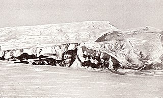
The escarpment was photographed from the air by the U.S. Navy, 1967, and was surveyed by British Antarctic Survey (BAS), 1968–71. It was named "Pioneers Escarpment" by the United Kingdom Antarctic Place-Names Committee (UK-APC) because features on the escarpment are named after the pioneers whose inventions have assisted living and traveling conditions in the polar regions.[1] The escarpment was visited and the rocks sampled extensively for the first time during the Geologische Expedition in die Shackleton Range (GEISHA) expedition in 1987–88.[2]
Geology
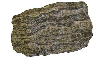
The outroppings in the escarpment typically contain a succession of sedimentary rocks and rocks of volcanic origin which make up the Pioneers Group, a subcrustal unit.[2] The metamorphic rocks of the Pioneers Group are a diverse series of metasedimentary rocks. Rock types include quartzites, mica schists, Al-rich schists and gneisses, calc-silicate schists, metalimestones and marbles, and amphibolites.[3]
Most of the rock types found in the escarpment are metamorphosed from amphibolitefacies, but cores of garnet contain traces of granulite facies. The metasedimentary rocks are from deposits that were laid down in shallow water on the submerged rim of a craton. During the peak of metamorphism both the sediments and the volcanics were subject to high pressures but relatively low temperatures of around 600°C (1,112°F). At this time they would have been as deep as 35 kilometres (22mi), but were probably uplifted before the Ross orogeny 500 million years ago. Additional sedimentation occurred after this, creating non-metamorphic shales, sandstones and greywackes that may date to the Jurassic (200–145 million years ago).[2]
80°25′S23°16′W / 80.417°S 23.267°W / -80.417; -23.267 Nunatak rising to 1,215 metres (3,986ft) at the west end of Pioneers Escarpment, Shackleton Range. In association with the names of pioneers of polar life and travel grouped in this area, named by the UK-APC in 1971 after Major Frederick George Jackson (1860-1938), English Arctic explorer who in 1895 designed the features of the pyramid tent, later to become standard equipment on British polar expeditions.[5]
Jackson Tooth has a visible band about 50 metres (160ft) thick of medium grained marble, coloured light grey to white, containing tremolite. Below this is a band about 100 metres (330ft) thick of grey marble, with up to 10% of its volume made up of star-like aggregates of chrysotile-asbestos. There may also be muscovite schists and muscovite quartzite holding accessory tourmaline, since rocks like this are seen about 2 kilometres (1.2mi) north of the nunatak.[6]
80°28′S22°28′W / 80.467°S 22.467°W / -80.467; -22.467. Mountain rising to c. 1,400 metres (4,600ft) to the west of Mount Kelsey in the Pioneers Escarpment, Shackleton Range. Photographed from the air by the U.S. Navy, 1967. Surveyed by the BAS, 1968-71. In association with the names of pioneers of polar life and travel grouped in this area, named by the UK-APC in 1971 after Adm. Sir Francis Leopold M'Clintock, RN (1819-1907), British Arctic explorer and pioneer in adopting Eskimo methods of overland travel; he took part in three Franklin search voyages, 1848–54, and commanded Fox, 1857-59, on the voyage to Arctic Canada that finally determined the fate of Sir John Franklin's expedition.[7]
The main rock types on M'Clintock Bastion are tremolite marble, garnet-two-mica schist and staurolite-garnet-muscovite schist.[6]
Mount Kelsey
80°27′S22°19′W / 80.450°S 22.317°W / -80.450; -22.317. Mountain rising to c. 1,370 metres (4,490ft) between M'Clintock Bastion and Blanchard Hill in the Pioneers Escarpment, Shackleton Range. In association with the names of pioneers of polar life and travel grouped in this area, named by UK-APC in 1971 after Henry Kelsey (1670-c. 1729), English employee of the Hudson's Bay company, first white man known to have adopted North American Indian methods of life and travel (including the use of pemmican) in 1691.[8]
Spaeth Nunatak
Spaeth Nunatak[lower-alpha 1] is on the 1,600 metres (5,200ft) contour line about 10 kilometres (6.2mi) south.south-west of Blanchard Hill. Rock types include impure marble which sometimes contains layers of quartzite. The coarse grained marble in other places includes rounded olivines, partly serpentinized, with chondrodite, opaque minerals and quartz. This marble has a high concentration of strontium, up to thirty times more than in other marbles of the Shackleton Range.[9]
80°23′S21°58′W / 80.383°S 21.967°W / -80.383; -21.967. A nunatak 3 miles (4.8km) north of Blanchard Hill, rising to 990 metres (3,250ft) in the Pioneers Escarpment, Shackleton Range. Photographed from the air by the U.S. Navy, 1967. Surveyed by BAS, 1968-71. In association with the names of pioneers of polar life and travel grouped in this area, named by the UK-APC in 1971 after Charles F. Meade (1881-1975), English mountaineer and designer of the Meade tent.[10]
Rocks exposed on the Meade Nunatak experienced two metamorphic overprints around 1700 and 500 million years ago.[11] The northern part of Meade Nunatak contains epidote-biotite-plagiocIase gneiss and epidote-biotite amphibolite. The amphibole has a texture that may indicate it has replaced cIinopyroxene. In the southern part of the nunatak there is biotite quartzite, biotite schist, garnet-biotite schist, plagiocIase gneiss with a small mica content, and plagiocIase-quartz-mica schists, There are also garnet-kyanitestaurolite-mica schists, staurolite-garnet-plagiocIase gneiss and perhaps a kyanite-quartzfels.[12]
80°26′S21°56′W / 80.433°S 21.933°W / -80.433; -21.933. A hill between Mount Kelsey and Whymper Spur in the Pioneers Escarpment, eastern Shackleton Range. Photographed from the air by the U.S. Navy, 1967. Surveyed by BAS, 1968-71. Named by the UK-APC after Robert Blanchard, American inventor of a light-weight tent using a rigidly tensioned frame erected outside the tent.[13]
The hill holds a garnet-mica schist and biotite-garnet-amphibole schist, which is intensely folded, and to the northwest is thrust up onto an intensely folded sequence of quartzite with layers 20 metres (66ft) thick holding beds about 40 centimetres (16in) thick of light grey calciphyre.[12]
Olesch Nunatak
Olesch Nunatak[lower-alpha 2] is about 4.5 kilometres (2.8mi) west.south-west of Whymper Spur. Rock types include a quartz-carbonate rock or carbonate-bearing quartzite, a garnet-two-mica schist and a garnet-hornblende-biotite schist.[12]
80°25′S21°29′W / 80.417°S 21.483°W / -80.417; -21.483. A rock spur rising to about 1,250 metres (4,100ft) eastward of Blanchard Hill in Pioneers Escarpment (q.v.), Shackleton Range. Named by the UK-APC in 1971 after English mountaineer and artist Edward Whymper (1840-1911), who made the first ascent of the Matterhorn, Switzerland, July 14, 1865; designer of the prototype of the Whymper tent, 1861-62.[14]
Whymper Spur has a layer about 80 to 100 metres (260 to 330ft) of marble with intercalated amphibolite mostly in boudins. The marble is a tremolite marble or a silicate marble containing cIinopyroxene and/or tremolite aggregates.[12]
Weissenstein
Weissenstein[lower-alpha 3] (White Spur) is an outcrop halfway between Mummery Cliff and Whymper Spur. It is composed of a very pure, even-grained, white marble. It is named for its white appearance.[12]
80°27′S21°23′W / 80.450°S 21.383°W / -80.450; -21.383. A cliff rising to c. 1,250 metres (4,100ft) to the southeast of Whymper Spur in the Pioneers Escarpment, Shackleton Range. In association with the names of pioneers of polar life and travel grouped in this area, named by the UK-APC in 1971 after Albert F. Mummery (1855-95), English mountaineer and designer of the Mummery tent.[15]
80°29′S20°56′W / 80.483°S 20.933°W / -80.483; -20.933. The cliffed extremity of a snow-capped ridge between Mummery Cliff and Chevreul Cliffs in Pioneers Escarpment, Shackleton Range. Photographed from the air by the U.S. Navy, 1967. Surveyed by BAS, 1968-71. In association with the names of pioneers of polar life and travel, named by the UK-APC after Louis V. Aronson (1870-1940), American founder of the Ronson Corporation, who in about 1910 developed the first practical petrol lighter, known originally as the "trench match."[16]
Aronson Corner rock types include metacarbonate with metaquartzite. Dark grey caleiphyres (phlogopite-tremolite-diopside marble) are found with quartz-tremolite rocks.[12]
80°32′S21°11′W / 80.533°S 21.183°W / -80.533; -21.183. A mountain rising to c. 1,600 metres (5,200ft) to the southwest of Aronson Corner in the Pioneers Escarpment, Shackleton Range. Photographed from the air by the U.S. Navy, 1967. Surveyed by BAS, 1968-71. In association with the names of pioneers of polar life and travel grouped in this area, named in 1971 by the UK-APC after Sir James Dewar (1842-1923), Scottish chemist and physicist who invented the thermos flask, c. 1892.[17]
Mount Dewar rock types include fine-grained fuchsite quartzite, with a very low proportion of mica, which occurswith amphibolite (as in Sauria Buttress) and microcline gneiss.[12]
80°32′S20°36′W / 80.533°S 20.600°W / -80.533; -20.600. Cliffs rising to c. 1,500 metres (4,900ft) to the east of Mount Dewar in Pioneers Escarpment, Shackleton Range. Photographed from the air by the U.S. Navy, 1967. Surveyed by BAS, 1968-71. In association with the names of pioneers of polar life and travel grouped in this area, named by the UK-APC after Michel Eugène Chevreul (1786-1889), French chemist whose research on the nature of fats in 1823 led to the invention of stearine candles, used subsequently by polar explorers.[18]
Chevreul Cliffs have marble with light green to yellow stains and wollastonite. A two-mica schist shows evidence of postcrystalline deforrnation. Some layers in the schist contain epidote and hornblende.[12]
80°31′S20°25′W / 80.517°S 20.417°W / -80.517; -20.417. A rock knoll rising to c. 1,400 metres (4,600ft) to the northeast of Chevreul Cliffs in Pioneers Escarpment, Shackleton Range. Photographed from the air by the U.S. Navy, 1967. Surveyed by BAS, 1968-71. Named by the UK-APC in association with the names of pioneers of polar life and travel grouped in this area, after Johan E. Lundstrom (1815–88), Swedish inventor of the first true "strike-on-box safety match" in 1855.[19]
Lundström Knoll has a two-mica gneiss that partly shows augen gneiss texture.[12]
80°32′S20°24′W / 80.533°S 20.400°W / -80.533; -20.400. A rock buttress rising to c. 1,300 metres (4,300ft) to the southeast of Lundstrom Knoll in Pioneers Escarpment, Shackleton Range. Photographed from the air by the U.S. Navy, 1967. Surveyed by BAS, 1968-71. In association with the names of pioneers of polar life and travel grouped in this area, named by UK-APC in 1971 after Charles Sauria (b. 1812), French inventor of the first practical friction match in 1831.[20]
Sauria Buttress has thick beds of quartzite containing fuchsite, which gives the quartzite a pale green appearance. The metamorphosed sandstone alternates with amphibolites.[12]
80°21′S24°01′W / 80.350°S 24.017°W / -80.350; -24.017. A nunatak 1.5 miles (2.4km) southwest of Baines Nunatak, midway between Herbert Mountains and Pioneers Escarpment in the Shackleton Range. Photographed from the air by the U.S. Navy, 1967, and surveyed by BAS, 1968-71. In association with the names of pioneers of polar life and travel grouped in this area, named by the UK-APC in 1971 after William B. Lord, Canadian artilleryman and joint author with T. Baines of Shifts and Expedients of Camp Life, Travel and Exploration, London, 1871.[21]
Rocks exposed on Lord Nunatak experienced a Pan-African metamorphic event around 515–500 million years ago.[11] Rock types include amphibolite, which was probably derived from an igneous rock. There are higher than usual concentrations of chromium, nickel and iron, so the parent rock may be a basic igneous rock such as basaltic komatiite. The nunatak also has gamet amphibolite and hornblende schists.[6]
80°19′S23°58′W / 80.317°S 23.967°W / -80.317; -23.967. Nunatak rising to 1,020 metres (3,350ft) to the east of Bernhardi Heights and 10 miles (16km) northwest of Jackson Tooth, Pioneers Escarpment, in the Shackleton Range. Photographed from the air by the U.S. Navy, 1967. Surveyed by BAS, 1968-71. Named in 1977 by the UK-APC after Thomas Baines (1822–75), English explorer and joint author, with W.B. Lord, of Shifts and Expedients of Camp Life, Travel and Exploration (London, 1871).[22]
Rock types include garnet-two-mica schist and hornblende-garnet-plagioclase gneiss.[6]
Notes
↑ In 1993 "Spaeth Nunatak" was a recently assigned name and was not yet officially approved.[6] It is not named on the 1983 United States Geological Survey map.[4]
↑ In 1993 "Olesch Nunatak" was a recently assigned name and was not yet officially approved.[12] It is not named on the 1983 United States Geological Survey map.[4]
↑ In 1993 "Weissenstein" was a recently assigned name and was not yet officially approved. [12] It is not named on the 1983 United States Geological Survey map.[4]
Related Research Articles
Gneiss is a common and widely distributed type of metamorphic rock. It is formed by high-temperature and high-pressure metamorphic processes acting on formations composed of igneous or sedimentary rocks. Gneiss forms at higher temperatures and pressures than schist. Gneiss nearly always shows a banded texture characterized by alternating darker and lighter colored bands and without a distinct cleavage.
Metamorphic rocks arise from the transformation of existing rock to new types of rock in a process called metamorphism. The original rock (protolith) is subjected to temperatures greater than 150 to 200 °C and, often, elevated pressure of 100 megapascals (1,000 bar) or more, causing profound physical or chemical changes. During this process, the rock remains mostly in the solid state, but gradually recrystallizes to a new texture or mineral composition. The protolith may be an igneous, sedimentary, or existing metamorphic rock.
The Shackleton Range is a mountain range in Antarctica that rises to 1,875 metres (6,152 ft) and extends in an east–west direction for about 100 miles (160 km) between the Slessor and Recovery Glaciers.
The Queen Maud Mountains are a major group of mountains, ranges and subordinate features of the Transantarctic Mountains, lying between the Beardmore and Reedy Glaciers and including the area from the head of the Ross Ice Shelf to the Antarctic Plateau in Antarctica. Captain Roald Amundsen and his South Pole party ascended Axel Heiberg Glacier near the central part of this group in November 1911, naming these mountains for the Norwegian queen Maud of Wales.
Granulites are a class of high-grade metamorphic rocks of the granulite facies that have experienced high-temperature and moderate-pressure metamorphism. They are medium to coarse–grained and mainly composed of feldspars sometimes associated with quartz and anhydrous ferromagnesian minerals, with granoblastic texture and gneissose to massive structure. They are of particular interest to geologists because many granulites represent samples of the deep continental crust. Some granulites experienced decompression from deep in the Earth to shallower crustal levels at high temperature; others cooled while remaining at depth in the Earth.
The Herbert Mountains are a conspicuous group of rock summits on the east side of Gordon Glacier in the Shackleton Range of Antarctica. They were first mapped in 1957 by the Commonwealth Trans-Antarctic Expedition and named for Sir Edwin S. Herbert, Chairman of the Finance Committee and a Member of the Committee of Management of the expedition, 1955–58.
The Wissahickon Formation is a mapped bedrock unit in Pennsylvania, New Jersey, and Delaware. It is named for the Wissahickon gorge in Fairmount Park, Philadelphia.
Shotton Snowfield is a large snowfield between Herbert Mountains and Pioneers Escarpment on the north and Read Mountains on the south, in the Shackleton Range of Antarctica.
Meade Nunatak is a nunatak 3 nautical miles (6 km) north of Blanchard Hill, rising to 990 metres (3,250 ft) in the Pioneers Escarpment, Shackleton Range, Antarctica. It was photographed from the air by the U.S. Navy, 1967, and was surveyed by the British Antarctic Survey, 1968–71. In association with the names of pioneers of polar life and travel grouped in this area, it was named by the UK Antarctic Place-Names Committee in 1971 after English mountaineer Charles Francis Meade, the designer of the Meade tent.
Jackson Tooth is a nunatak rising to 1,215 metres (3,990 ft) at the western end of Pioneers Escarpment, in the Shackleton Range, Antarctica. In association with the names of pioneers of polar life and travel grouped in this area, it was named by the UK Antarctic Place-Names Committee in 1971 after Major Frederick George Jackson, an English Arctic explorer who in 1895 designed the features of the pyramid tent, later to become standard equipment on British polar expeditions.
Whymper Spur is a rock spur rising to about 1,250 m eastward of Blanchard Hill in Pioneers Escarpment, Shackleton Range. Named by the United Kingdom Antarctic Place-Names Committee (UK-APC) in 1971 after English mountaineer and artist Edward Whymper (1840–1911), who made the first ascent of the Matterhorn, Switzerland, July 14, 1865; designer of the prototype of the Whymper tent, 1861–62.
Mummery Cliff is a cliff situated in Antarctica rising to about 1,250 m to the southeast of Whymper Spur in the Pioneers Escarpment, Shackleton Range. In association with the names of pioneers of polar life and travel grouped in this area, named by the United Kingdom Antarctic Place-Names Committee (UK-APC) in 1971 after Albert F. Mummery (1855–95), English mountaineer and designer of the Mummery tent.
Fuchs Dome is a large ice-covered dome rising over 1,525 metres (5,000 ft), between Stratton Glacier and Gordon Glacier in the central part of the Shackleton Range, Antarctica.
The Du Toit Nunataks are a group of nunataks between Cornwall Glacier and Glen Glacier, marking the western end of the Read Mountains in the Shackleton Range of Antarctica.
The Haskard Highlands are a range of peaks and ridges between Blaiklock Glacier and Stratton Glacier in the northwest of the Shackleton Range, Antarctica, rising to 1,210 metres (3,970 ft) at Mount Weston and including features between Mount Provender and Pointer Nunatak. The highlands were first mapped in 1957 by the Commonwealth Trans-Antarctic Expedition, and photographed from the air by the U.S. Navy in 1967. They were surveyed by the British Antarctic Survey between 1968 and 1971, and named by the UK Antarctic Place-Names Committee in 1971 after Sir Cosmo Haskard, Governor of the Falkland Islands 1964–70.
Read Mountains is a group of rocky summits, the highest being Holmes Summit at 1,875 metres (6,152 ft), lying east of Glen Glacier in the south-central part of the Shackleton Range.
La Grange Nunataks is a scattered group of nunataks extending west for 22 nautical miles (41 km) from the mouth of Gordon Glacier, on the north side of the Shackleton Range, Antarctica. They were first mapped in 1957 by the Commonwealth Trans-Antarctic Expedition (CTAE), and were photographed in 1967 by U.S. Navy aircraft. They were named by the UK Antarctic Place-Names Committee for Johannes J. La Grange, a South African meteorologist with the CTAE. Not: Beney Nunataks.
The geology of North Macedonia includes the study of rocks dating to the Precambrian and a wide array of volcanic, sedimentary and metamorphic rocks formed in the last 539 million years.
The geology of Wisconsin includes Precambrian crystalline basement rock over three billion years old. A widespread marine environment during the Paleozoic flooded the region, depositing sedimentary rocks which cover most of the center and south of the state.
The Ashe Metamorphic Suite, also referred to as the Ashe Formation, was named after its type locality, Ashe County, North Carolina. The Ashe Metamorphic Suite is located in the Eastern Blue Ridge providence that extends from North Carolina up to South-Western Virginia. It is a collection of metamorphic rocks of both sedimentary and volcanic origin. Zircon dating indicates an age of 470 to 335 Ma for the unit. The protolith of the Ashe Metamorphic Suite was deposited during the Late Proterozoic and reaching its cooling age during the end of the Devonian. The Ashe Metamorphic Suite is overwhelmingly composed of amphibolites and mica schists.
Will, Thomas; Gerdes, Axel; Frimmel, Hartwig (2009), "Palaeoproterozoic to Palaeozoic magmatic and metamorphic events in the Shackleton Range, East Antarctica: Constraints from zircon and monazite dating, and implications for the amalgamation of Gondwana", Precambrian Research, doi:10.1016/j.precamres.2009.03.008
This page is based on this Wikipedia article Text is available under the CC BY-SA 4.0 license; additional terms may apply. Images, videos and audio are available under their respective licenses.


