Pisgah, Illinois | |
|---|---|
 Pisgah  Pisgah | |
| Coordinates: 39°40′07″N90°07′32″W / 39.66861°N 90.12556°W | |
| Country | United States |
| State | Illinois |
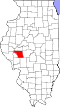
| County | Morgan |
| Elevation | 673 ft (205 m) |
| Time zone | UTC-6 (Central (CST)) |
| • Summer (DST) | UTC-5 (CDT) |
| Area code | 217 |
| GNIS feature ID | 423068 [1] |
Pisgah is an unincorporated community in Morgan County in the U.S. state of Illinois, southeast of Jacksonville. [1] [2] Pisgah is located on Illinois Route 104.