
Transylvania County is a county in the U.S. state of North Carolina. As of the 2020 census the population is 32,986. Its county seat is Brevard.
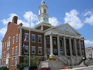
Woodford County is a county located in the U.S. state of Kentucky. As of the 2020 census, the population was 26,871. Its county seat is Versailles. The area was home to Pisgah Academy. Woodford County is part of the Lexington-Fayette, KY Metropolitan Statistical Area. It is located in the center of the Bluegrass region of Kentucky.
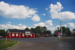
Pisgah is a town in Jackson County, Alabama, United States, and is included in the Huntsville-Decatur Combined Statistical Area. It incorporated in 1947. As of the 2020 census, the population of the town was 681, down from 722 in 2010. Pisgah is located atop Sand Mountain.

Pisgah is a city in Harrison County, Iowa, United States, along the Soldier River. The community is located in the midst of the Loess Hills. The population was 249 at the time of the 2020 census.
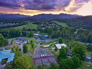
Mount Pisgah Academy is a four-year secondary education boarding and day school located in Candler, North Carolina, United States, near Asheville. The academy is named after the Mount Pisgah of biblical reference as well as its proximity to Mount Pisgah in the Blue Ridge Mountains.

Mount Pisgah is a mountain in the Appalachian mountain range and part of the Blue Ridge Mountains of North Carolina, United States. The mountain's height is 5,721 feet above sea level, and it sits approximately 15 miles southwest of Asheville, near the crossing of the boundaries of Buncombe, Haywood, Henderson and Transylvania counties. It is located on the border of Buncombe and Haywood counties, close to the point where Henderson and Transylvania meet them, but not actually within the latter two counties. The mountain is easily accessible via a hiking trail from the Blue Ridge Parkway, near the Pisgah Inn.

Pisgah National Forest is a National Forest in the Appalachian Mountains of western North Carolina. It is administered by the United States Forest Service, part of the United States Department of Agriculture. The Pisgah National Forest is completely contained within the state of North Carolina. The forest is managed together with the other three North Carolina National Forests from common headquarters in Asheville, North Carolina. There are local ranger district offices located in Pisgah Forest, Mars Hill, and Nebo.

Samuel S. Lewis State Park is an 85-acre (34 ha) Pennsylvania state park in Lower Windsor Township, York County, Pennsylvania, in the United States. Mt. Pisgah is an 885-foot-high (270 m) ridge that is the focus of recreation for the park. The ridge separates East Prospect Valley from Kreutz Creek Valley. An overlook on Mt. Pisgah gives visitors of view of the Susquehanna River Valley. Samuel S. Lewis Park is twelve miles (19 km) east of York near U.S. Highway 30.

Mt. Pisgah State Park is a 1,302-acre (527 ha) Pennsylvania state park in Smithfield, Springfield, Troy and West Burlington Townships, Bradford County, Pennsylvania in the United States. The park is located almost exactly halfway between Troy and Towanda, along Pennsylvania State Route 3019, near U.S. Route 6, at the base of Mt. Pisgah. The park is bordered by Mill Creek, Mt. Pisgah County Park and State Game Land 289. Mill Creek which flows through the park has been dammed and forms Stephen Foster Lake a 75-acre (30 ha) man-made lake.

Ellisville Township is one of twenty-six townships in Fulton County, Illinois, USA. As of the 2010 census, its population was 155 and it contained 69 housing units.

Black Balsam Knob, also known as Black Balsam Bald, is in the Pisgah National Forest southwest of Asheville, North Carolina, near milepost 420 on the Blue Ridge Parkway. It is the second highest mountain in the Great Balsam Mountains. The Great Balsams are within the Blue Ridge Mountains, which are part of the Appalachian Mountains. It is the 23rd highest of the 40 mountains in North Carolina over 6000 feet.
Pisgah State Park is a 13,300-acre (5,400 ha) public recreation area located in the Cheshire County towns of Winchester, Chesterfield and Hinsdale in New Hampshire. It is the largest state park in New Hampshire and contains a complete watershed north of the Ashuelot River, seven ponds, four highland ridges, numerous wetlands, and a 20-acre (8 ha) parcel of old-growth forest.
Mount Pisgah is an unincorporated community in Milford Township, LaGrange County, Indiana.
Pisgah is an unincorporated community in Preston County, West Virginia, United States.

Pisgah Mountain or Pisgah Ridge is a ridgeline running 12.5 miles (20.1 km) from Tamaqua to Jim Thorpe, Pennsylvania. It is oriented north-northeast to south-southwest, and its north-side valley is followed by U.S. Route 209 from river gap to river gap. The ridge is a succession of peaks exceeding 1,440 feet (438.9 m) rising 300 to 540 feet above the boroughs of Lansford, Coaldale, and Tamaqua in the Panther Creek valley. The highest point on Pisgah Mountain is at 1,611 feet (491 m) in the borough of Summit Hill, which sits atop the ridge. Near Summit Hill was the "Sharpe Mountain" (peak) where in 1791 Phillip Ginter is documented as having discovered anthracite, leading to the formation of the Lehigh Coal Mine Company. In 1818 the Lehigh Coal Company took over the mines, and the mining camp gradually became a settlement and grew into Summit Hill.
Pisgah is an unincorporated community in Butler County, in the U.S. state of Ohio.
Mount Pisgah is a mountain located in the Catskill Mountains of New York north of Windham. Steenburg Mountain is located northwest, Richtmyer Peak is located west, and Mount Nebo is located southeast of Mount Pisgah.
Richtmyer Peak is a mountain in Greene County, New York and partly in Schoharie County, New York. It is located in the Catskill Mountains southwest of West Durham. Mount Pisgah is located east, and Richmond Mountain is located southwest of Richtmyer Peak.
Pisgah View State Park is a developing 205-acre (0.83 km2) North Carolina state park in Buncombe and Haywood Counties, North Carolina, in the United States. The center piece of the park is the approximately 1,600-acre (6.5 km2) Pisgah View Ranch, which has rental cabins, equestrian trails, a swimming pool, tennis courts and other amenities. The ranch has been privately owned by the Cogburn Family since the late 1700s, and the state acquired an option to purchase the property over a five-year period. The Southern Appalachian Highlands Conservancy has raised $1 million to aid with the purchase. The Cogburns will donate a portion of the land's value to the state.

Mount Pisgah is a 2,090-foot-tall (640 m) mountain in Essex County on the northern edge of the village of Saranac Lake. The mountain is privately owned. There is a small, dispersed housing development on the south side, communications towers on the summit, and a village ski area on the north side.


