
The Glarus Alps are a mountain range in central Switzerland. They are bordered by the Uri Alps and the Schwyz Alps to the west, the Lepontine Alps to the south, the Appenzell Alps to the northeast. The eastern part of the Glarus Alps contains a major thrust fault that was declared a geologic UNESCO World Heritage Site.

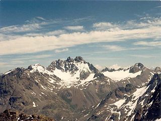
The Silvretta Alps are a mountain range of the Central Eastern Alps shared by Tirol, Vorarlberg and Graubünden (Switzerland). The Austrian states of Tirol and Vorarlberg are connected by a pass road. The majority of the peaks are elevated above three thousand metres and are surrounded by glaciers. Thus, the area is also known as the "Blue Silvretta".

Piz Bernina is the highest mountain in the Eastern Alps, the highest point of the Bernina Range, and the highest peak in the Rhaetian Alps. It rises 4,048.6 m (13,283 ft) and is located south of Pontresina and near the major Alpine resort of St. Moritz, in the Engadin valley. It is also the most easterly mountain higher than 4,000 m (13,000 ft) in the Alps, the highest point of the Swiss canton of Graubünden, and the fifth-most prominent peak in the Alps. Although the summit lies within Switzerland, the massif is on the border with Italy. The "shoulder" known as La Spedla is the highest point in the Italian Lombardy region.
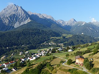
The Sesvenna Alps are a mountain range located in the Alps of eastern Switzerland, northern Italy and western Austria.
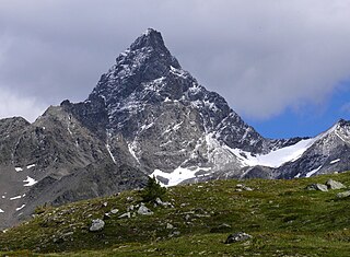
The Fluchthorn or Piz Fenga is a mountain in the Silvretta Alps, located on the border between Austria and Switzerland. With a height of 3,399 metres (11,152 ft) above sea level, it is the second highest summit of the Silvretta Alps. The Fluchthorn lies between the Jamtal (Tyrol) and the Val Fenga (Graubünden). It consists of three summits of which the southern one is the highest.

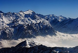
Eastern Alps is the name given to the eastern half of the Alps, usually defined as the area east of a line from Lake Constance and the Alpine Rhine valley up to the Splügen Pass at the Alpine divide and down the Liro River to Lake Como in the south. The peaks and mountain passes are lower than the Western Alps, while the range itself is broader and less arched.
The Rheinwaldhorn is the highest point in the Swiss canton of Ticino at 3,402 metres above sea level. It lies on the border between the cantons of Graubünden and Ticino, in the Adula massif, part of the St. Gotthard massif of the Lepontine Alps in southern Switzerland.
Piz Kesch (German) or Piz d'Es-cha (Rumantsch) is a peak in the Albula Alps of the Rhaetian Alps in Switzerland. At 3,418 metres (11,214 ft), it is the highest peak in the Albula Alps and the municipality of Bergün, Grisons.

The Bregaglia Range is a small group of mostly granite mountains in Graubünden, Switzerland and the Province of Sondrio, northern Italy. It derives its name from the partly Swiss, partly Italian valley, the Val Bregaglia, and is known as Bergell in German. Other names which are applied to the range include the Val Masino Alps and, to describe the main ridge, Masino-Bregaglia-Disgrazia. Vicosoprano is the main settlement in the Swiss part of the range.

Zervreilasee is a reservoir located south-west of Vals in the canton of Graubünden, Switzerland.

Val Poschiavo is a valley in the southern, Italian-speaking part of the Swiss canton of Graubünden (Grisons). The main town is Poschiavo.
The Diavolezza is a col and ski resort above the Val Bernina in Graubünden. The col has an altitude of 2,958 metres (9,705 ft) and is located between Munt Pers and Piz Trovat.

Piz Quattervals is a mountain of the Livigno Alps, located in Graubünden, Switzerland. With a height of 3,165 metres above sea level, Piz Quattervals is the highest mountain of the chain north of Pass Chaschauna. Its mass lies between four valleys: Val Tantermozza, Valletta, Val Sassa and Val Müschauns, although its summit lies between the first three mentioned. Piz Quattervals is the highest accessible peak within the Swiss National Park.

The Stelvio Pass is a mountain pass in northern Italy bordering Switzerland at an elevation of 2,757 m (9,045 ft) above sea level. It is the highest paved mountain pass in the Eastern Alps, and the second highest in the Alps, 7 m (23 ft) below France's Col de l'Iseran.

The Schams is a section of the Hinterrhein valley in the Swiss canton of Graubünden.

The Val Russein is a valley of the Swiss Alps, located south of the Tödi Group in Graubünden. The valley is drained by the Aua da Russein, a tributary of the Vorderrhein, near Cumpadials. The Val Russein belongs to the municipalities of Disentis and Sumvitg.

The Val Roseg is a valley of the Swiss Alps, located on the north side of the Bernina Range in the canton of Graubünden (Engadin). The valley is drained by the Ova da Roseg, a tributary of the Flaz, at Pontresina. Most of the valley is part of an exclave of the municipality of Samedan. Only the bottom of Val Roseg lies in the municipality of Pontresina.

Piz Buin Pitschen (Rumantsch) or Kleiner Piz Buin (German) is a peak in the Silvretta Alps. The Piz Buin Pitschen lies western of his higher neighbor the Piz Buin Grond or Großer Piz Buin.


