
The Tödi, is a mountain massif and with the mountain peak Piz Russein the highest mountain in the Glarus Alps and the highest summit in the canton of Glarus, Switzerland. It is located on the border between the cantons of Graubünden, to the south, and Glarus, to the north, close to the point where those two cantons meet the canton of Uri, to the west. Although not the culminating point of Graubünden, it is its highest peak outside the Bernina range.

The Aiguille de Bionnassay is a mountain in the Mont Blanc massif of the Alps in France and Italy. It has been described as "one of the most attractive satellite peaks of Mont Blanc", and is located on its western side. The mountain's south and east ridges form the frontier between the two countries, and its summit is a knife-edge crest of snow and ice. Reaching it via any route provides a "splendid and serious snow and ice climb".

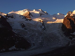
Piz Bernina is the highest mountain in the Eastern Alps, the highest point of the Bernina Range, and the highest peak in the Rhaetian Alps. It rises 4,048 m (13,281 ft) and is located south of Pontresina and near the major Alpine resort of St. Moritz, in the Engadin valley. It is also the most easterly mountain higher than 4,000 m (13,000 ft) in the Alps, the highest point of the Swiss canton of Graubünden, and the fifth-most prominent peak in the Alps. Although the summit lies within Switzerland, the massif is on the border with Italy. The "shoulder" known as La Spedla is the highest point in the Italian Lombardy region.

The Bernina Range is a mountain range in the Alps of eastern Switzerland and northern Italy. It is considered to be part of the Rhaetian Alps within the Central Eastern Alps. It is one of the highest ranges of the Alps, covered with many glaciers. Piz Bernina, its highest peak, is the most easterly four-thousand-metre peak in the Alps. The peak in the range which sees the most ascents is Piz Palü.
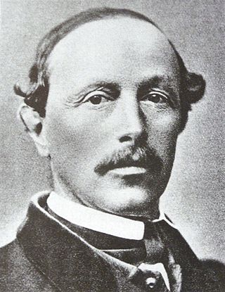
Christian Klucker was a Swiss mountain guide who made many first ascents in the Alps, particularly in the Bernina Range, the Bregaglia and the Pennine Alps.
Piz Kesch (German) or Piz d'Es-cha (Rumantsch) is a peak in the Albula Alps of the Rhaetian Alps in Switzerland. At 3,418 metres (11,214 ft), it is the highest peak in the Albula Alps and the municipality of Bergün, Grisons.

The Schreckhorn is a mountain in the Bernese Alps. It is the highest peak located entirely in the canton of Bern. The Schreckhorn is the northernmost Alpine four-thousander and the northernmost summit rising above 4,000 metres in Europe.

Piz Palü is a mountain in the Bernina Range of the Alps, located between Switzerland and Italy. It is a large glaciated massif composed of three main summits, on a ridge running from west to east. The main summit is 3,899 metres high and is located within the Swiss canton of Graubünden, although the border with the Italian region of Lombardy runs about 100 metres west of it at almost the same height. The western summit is named Piz Spinas and is the only one not covered by ice. The eastern summit is named Piz Palü Orientale. The name Palü derives from the Latin palus, meaning a swamp, and the mountain is said to be named after the Alpe Palü, a high alpine pasture some 4 km to its east.

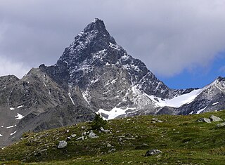
Piz Badile is a mountain of the Bregaglia range in the Swiss canton of Graubünden and the Italian region of Lombardy. The border between the two countries runs along the summit ridge. Its north-east face, overlooking the Swiss Val Bregaglia near Soglio, is considered one of the six great north faces of the Alps. The name Badile means spade or shovel.

Piz Roseg is a mountain of the Bernina Range, overlooking the Val Roseg in the Swiss canton of Graubünden.

Piz da la Margna is a mountain in the Bernina Range of the Alps, overlooking Lake Sils in the Swiss canton of Graubünden. It lies to the south-east of the Maloja Pass at the south-western end of the Engadin valley.

Piz Tschierva is a mountain in the Bernina Range of the Alps, located south of Pontresina in the canton of Graubünden. It lies in the range that separates the valley of Roseg from the valley of Morteratsch, north of Piz Bernina. Its summit is located within the valley of Roseg.

Crast' Agüzza is a mountain in the Bernina Range in Italy and Switzerland.
Piz Argient is a mountain in the Bernina Range of the Alps on the border between Italy and the Swiss canton of Graubünden.

Piz Fora is a mountain in the Bernina Range (Alps), on the border of Italy and Switzerland. The mountain has an elevation of 3,363 metres (11,033 ft) and is the tripoint between the valleys of Val Fedoz, Val Fex and Val Malenco.

The Marco e Rosa Hut is a high mountain refuge located on the southern slopes of the Piz Bernina in Italy. It lies adjacent to the Swiss border. The hut is positioned on the Fourcla Crast' Aguzza and is the highest known mountain hut in Lombardy. It requires mountaineering experience to reach it safely. Its location on the southern ridge (Spallagrat) of the Piz Bernina makes it an important staging post in ascending that mountain.

The Val Roseg is a valley of the Swiss Alps, located on the north side of the Bernina Range in the canton of Graubünden (Engadin). The valley is drained by the Ova da Roseg, a tributary of the Flaz, at Pontresina. Most of the valley is part of an exclave of the municipality of Samedan. Only the bottom of Val Roseg lies in the municipality of Pontresina.
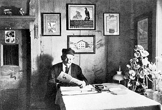
Johann Wilhelm Fortunat Coaz was a Swiss forester, topographer and mountaineer from Graubünden. In 1850 he made the first ascent of Piz Bernina, the highest mountain in the Eastern Alps. He also gave Piz Bernina its name, after the eponymous pass.

Thomas Middlemore was an English mountaineer who made multiple first ascents during the silver age of alpinism. His audacity earned him a reputation as the enfant terrible within the Alpine Club. He was also the head of the Middlemores Saddles leather goods company in Birmingham, England, after the retirement of his father, William Middlemore, in 1881. Thomas Middlemore had taken over the management of the company in 1868 and established a bicycle saddle factory in Coventry.

Piz Buin Pitschen (Rumantsch) or Kleiner Piz Buin (German) is a peak in the Silvretta Alps. The Piz Buin Pitschen lies western of his higher neighbor the Piz Buin Grond or Großer Piz Buin.


