Plaza Dorrego

Last updated
Plaza Dorrego Buenos Aires - Plaza Dorrego - 20061204b.jpg
Plaza Dorrego

Plaza Dorrego (Spanish : Dorrego Square) is a square located in the heart of San Telmo, in Buenos Aires, Argentina. In the 19th century, San Telmo was the main residential barrio (neighbourhood) of the city and Plaza Dorrego was its focal point.

Spanish language Romance language

Spanish or Castilian is a Romance language that originated in the Castile region of Spain and today has hundreds of millions of native speakers in the Americas and Spain. It is a global language and the world's second-most spoken native language, after Mandarin Chinese.

Buenos Aires Place in Argentina

Buenos Aires is the capital and largest city of Argentina. The city is located on the western shore of the estuary of the Río de la Plata, on the South American continent's southeastern coast. "Buenos Aires" can be translated as "fair winds" or "good airs", but the former was the meaning intended by the founders in the 16th century, by the use of the original name "Real de Nuestra Señora Santa María del Buen Ayre". The Greater Buenos Aires conurbation, which also includes several Buenos Aires Province districts, constitutes the fourth-most populous metropolitan area in the Americas, with a population of around 15.6 million.

Argentina federal republic in South America

Argentina, officially the Argentine Republic, is a country located mostly in the southern half of South America. Sharing the bulk of the Southern Cone with Chile to the west, the country is also bordered by Bolivia and Paraguay to the north, Brazil to the northeast, Uruguay and the South Atlantic Ocean to the east, and the Drake Passage to the south. With a mainland area of 2,780,400 km2 (1,073,500 sq mi), Argentina is the eighth-largest country in the world, the fourth largest in the Americas, and the largest Spanish-speaking nation. The sovereign state is subdivided into twenty-three provinces and one autonomous city, Buenos Aires, which is the federal capital of the nation as decided by Congress. The provinces and the capital have their own constitutions, but exist under a federal system. Argentina claims sovereignty over part of Antarctica, the Falkland Islands, and South Georgia and the South Sandwich Islands.

In the past it was referred to as Hueco del Alto or Alto de la carretas as it was the place where wagons would stop before crossing the Tercero del Sur stream (today called Pasaje San Lorenzo) on their way downtown. The name had been Alto de San Pedro and later changed to Plaza del Comercio in 1822. In 1905, the name was changed once again to its current form.

The buildings located in the square maintain its original design thanks to the help of the Comisión del Museo de la Ciudad.

Currently, its surroundings are full of cafes, bars and pubs, which fill the square with tables from those shops. There are also several antique stores. Musicians and dancers particularly tango exhibitions are seen, like the Argentine tango. The Feria de San Telmo (San Telmo Fair), mainly of antiques, runs every Sunday.

Argentine tango music genre

Argentine tango is a musical genre and accompanying social dance originating at the end of the 19th century in the suburbs of Buenos Aires and Montevideo. It typically has a 2
4
or 4
4
rhythmic time signature, and two or three parts repeating in patterns such as ABAB or ABCAC. Its lyrics are marked by nostalgia, sadness, and laments for lost love. The typical orchestra has several melodic instruments and is given a distinctive air by the small button accordion called the bandoneon. It has continued to grow in popularity and spread internationally, adding modern elements without replacing the older ones. Among its leading figures are the singer and songwriter Carlos Gardel and composers/performers Francisco Canaro, Juan D'Arienzo, Carlos Di Sarli, Osvaldo Pugliese, and Ástor Piazzolla.

Feria de San Telmo

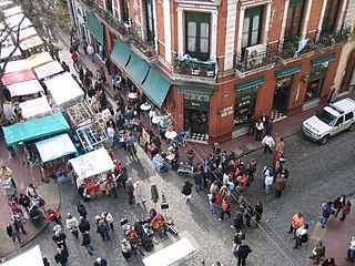
Feria de San Telmo is an antique fair that takes place in the barrio (neighbourhood) of San Telmo, in Buenos Aires, Argentina. It was created in 1970 by architect José María Peña.

Plaza Dorrego is located at the intersection of Humberto Primero and Defensa streets. Along with La Boca, Recoleta, Florida Street, and others, the Plaza Dorrego is one of the main tourist attractions of Buenos Aires. [1]

La Boca Barrio in Buenos Aires, Argentina

La Boca is a neighborhood, or barrio of the Argentine capital, Buenos Aires. It retains a strong Italian flavour, with many of its early settlers being from the city of Genoa.

Recoleta, Buenos Aires Barrio in Buenos Aires, Argentina

Recoleta is a downtown residential neighborhood in Buenos Aires, Argentina. It is an area of great historical and architectural interest, due to its Beaux-Arts architecture as well as the distinguished Recoleta Cemetery. It is also an important tourist destination in the city.

Florida Street street

Florida Street is a popular shopping street in Downtown Buenos Aires, Argentina. A pedestrian street since 1971, some stretches have been pedestrianized since 1913.

Tango music music genre

Tango is a style of music in 2
4
or 4
4
time that originated among European immigrant populations of Argentina and Uruguay. It is traditionally played on a solo guitar, guitar duo, or an ensemble, known as the orquesta típica, which includes at least two violins, flute, piano, double bass, and at least two bandoneóns. Sometimes guitars and a clarinet join the ensemble. Tango may be purely instrumental or may include a vocalist. Tango music and dance have become popular throughout the world.

Related Research Articles

San Telmo, Buenos Aires Barrio in Buenos Aires, Argentina

San Telmo is the oldest barrio (neighborhood) of Buenos Aires, Argentina. It is a well-preserved area of the Argentine metropolis and is characterized by its colonial buildings. Cafes, tango parlors and antique shops line the cobblestone streets, which are often filled with artists and dancers. A street named the "Illuminated Block" is where many of these important historical buildings can be found.

Balvanera Barrio in Buenos Aires, Argentina

Balvanera is a neighborhood ("barrio") of Buenos Aires, Argentina.

Palermo, Buenos Aires Barrio in Buenos Aires, Argentina

Palermo is a neighborhood, or barrio of the Argentine capital, Buenos Aires. It is located in the northeast of the city, bordering the barrios of Belgrano to the north, Almagro and Recoleta to the south, Villa Crespo and Colegiales to the west and the Río de la Plata river to the east. With a total area of 17.4 km2 (7 sq mi), Palermo is the largest neighborhood in Buenos Aires. As of 1991 it had a population of 256,927 inhabitants. It is the only barrio within the administrative division of Comuna 14.

Villa Crespo Barrio in Buenos Aires, Argentina

Villa Crespo is a middle-class neighbourhood in Buenos Aires, Argentina, located in the geographical centre of the city. It had a population of 83,646 people in 2001, and thus population density of 23,235 inhabitants/km2. Villa Crespo celebrates its anniversary on June 3.

Almagro, Buenos Aires Barrio in Buenos Aires, Argentina

Almagro is a mostly middle-class barrio (neighbourhood) of Buenos Aires, Argentina.

Nueva Pompeya Barrio in Buenos Aires, Argentina

Nueva Pompeya is a neighbourhood in the city of Buenos Aires, Argentina. Located in the South side, it has long been one of the city's proletarian districts steeped in the tradition of tango and one where many of the first tangos were written and performed.

Retiro, Buenos Aires Barrio in Buenos Aires, Argentina

Retiro is a barrio (district) in Buenos Aires, Argentina. Located in the northeast end of the city, Retiro is bordered on the south by the Puerto Madero and San Nicolás barrios, and on the west by the Recoleta barrio.

Avenida Corrientes Thoroughfare in Buenos Aires, Argentina, main street of the citys nightlife and theatre district

Avenida Corrientes is one of the principal thoroughfares of the Argentine capital of Buenos Aires. The street is intimately tied to the tango and the porteño sense of identity. Like the parallel avenues Santa Fe, Córdoba, and San Juan, it takes its name from one of the Provinces of Argentina.

Colegiales Barrio in Buenos Aires, Argentina

Colegiales is a barrio or district in Buenos Aires, Argentina. It is located between Alvarez Thomas av., Forest av., De los Incas av., Virrey del Pino st., Cabildo av., Jorge Newbery st., Crámer st. and Dorrego av. This neighborhood offers a vast amount of contrast and opportunities. There are large and tall buildings that go from the Crámer street to Avenida Cabildo and traditional houses up to three stories. This district has become a busy one with lots of pedestrians and cars that go about on the streets. This neighborhood is mainly residential, with some non-residential areas like the classification yard in the north-east zone, the fairs in the south-west, and the UCA Colegiales campus in the south-east.

Tourism in Buenos Aires

Buenos Aires is in the midst of a tourism boom, according to the World Travel & Tourism Council, which reveals strong growth for Argentina Travel and Tourism in 2007 and in coming years, and the prestigious travel and tourism publication; Travel + Leisure, a monthly magazine, travelers voted Buenos Aires the second most desirable city to visit after Florence, Italy. Buenos Aires, regarded as the “Paris of South America”, offers elegant architecture, exquisite cuisine, a legendary nightlife, and fashionable shopping. Argentina has become famous for its rich European flavor.

Mataderos Barrio in Buenos Aires, Argentina

Mataderos is a neighborhood in The Autonomous City of Buenos Aires, Argentina, belonging to the 9th Comuna (district).

Plaza San Martín (Buenos Aires) square in Buenos Aires, Argentina

Plaza San Martín is a park located in the Retiro neighbourhood of Buenos Aires, Argentina. Situated at the northern end of pedestrianized Florida Street, the park is bounded by Libertador Ave. (N), Maipú St. (W), Santa Fe Avenue (S), and Leandro Alem Av. (E). Its coordinates are 34°35′42″S58°22′32″W.

Monserrat, Buenos Aires Barrio in Buenos Aires, Argentina

Monserrat or Montserrat is a neighbourhood in the east of the Buenos Aires CBD. The district features some of the most important public buildings in Buenos Aires, including city hall, the city legislature, Casa Rosada, the Colegio Nacional de Buenos Aires and the Libertador Building, among others.

Plaza de la República (Buenos Aires) public square in Buenos Aires, Argentina

Plaza de la República is a city square in Buenos Aires, capital of Argentina. It is located in the San Nicolás quarter, at the intersection of the city's three main arteries: Ninth of July Avenue, Corrientes Avenue, and Diagonal Norte. It derives its name and associations from a church once sited on the square, San Nicolás de Bari, where the country's national flag was hoisted for the first time.

Avenida Santa Fe avenue in Buenos Aires, Argentina

Avenida Santa Fe is one of the principal thoroughfares in Buenos Aires, Argentina. The artery is essential to the imaginary axis of Barrio Norte in Buenos Aires, comprising the areas influenced by the route of the avenue through Retiro, Recoleta and Palermo neighborhoods, it is considered one of the main shopping and strolling areas of the city, its many boutiques range from elegant to edgy, which has led it to be dubbed the 'Avenue of Fashion'. Upscale Alto Palermo, at Avenida Coronel Díaz, is one of the city's best-known vertical malls. Avenida Santa Fe is also an attraction for its architecture, strongly reminiscent of Paris. Its name pays homage to the eponymous province in Argentina.

Buenos Aires Central Business District Unofficial Barrio in Buenos Aires, Argentina

The Buenos Aires Central Business District is the main commercial centre of Buenos Aires, Argentina, though not an official city ward. While the barrios of Puerto Madero and Retiro house important business complexes and modern high-rise architecture, the area traditionally known as Microcentro is located within San Nicolás and Monserrat, roughly coinciding with the area around the historic center of the Plaza de Mayo. The Microcentro has a wide concentration of offices, service companies and banks, and a large circulation of pedestrians on working days. Another name given to this unofficial barrio is La City, which refers more precisely to an even smaller sector within the Microcentro, where almost all the banking headquarters of the country are concentrated.

Avenida Leandro N. Alem street in Buenos Aires, Argentina

Avenida Leandro N. Alem is one of the principal thoroughfares in Buenos Aires, Argentina, and a commercial nerve center of the city's San Nicolás and Retiro districts.

References

  1. buenosaires.gov.ar, "Plaza Dorrego"

Coordinates: 34°37′14″S58°22′18″W / 34.62056°S 58.37167°W / -34.62056; -58.37167

Geographic coordinate system Coordinate system

A geographic coordinate system is a coordinate system that enables every location on Earth to be specified by a set of numbers, letters or symbols. The coordinates are often chosen such that one of the numbers represents a vertical position and two or three of the numbers represent a horizontal position; alternatively, a geographic position may be expressed in a combined three-dimensional Cartesian vector. A common choice of coordinates is latitude, longitude and elevation. To specify a location on a plane requires a map projection.