
Detroit is an unincorporated community in Dickinson County, Kansas, United States. As of the 2020 census, the population of the city was 102.
Anness is an unincorporated community in Sedgwick County, Kansas, United States, about 4.75 miles west of Viola, between W 111th St S and W 119th St S, and between S 327th St W and S 343rd St W.

Galt is a ghost town in central Galt Township, Rice County, Kansas, United States. It was located near the Little Arkansas River, 6 miles (9.7 km) southeast of Geneseo and 14 miles (23 km) northeast of Lyons.

LeLoup is an unincorporated community in Franklin County, Kansas, United States. It is located a mile and half north of Interstate 35 on Tennessee Road, 11 miles northeast of Ottawa, 7 miles southwest of Wellsville.

Franklin is an unincorporated community in Crawford County, Kansas, United States. As of the 2020 census, the population of the community and nearby areas was 473. Franklin is located along U.S. Route 69, 1 mile (1.6 km) south of Arma, or 5.9 miles (9.5 km) north of Frontenac.

Pleasant Grove is an unincorporated community in Douglas County, Kansas, United States. It is located four miles south of Lawrence.
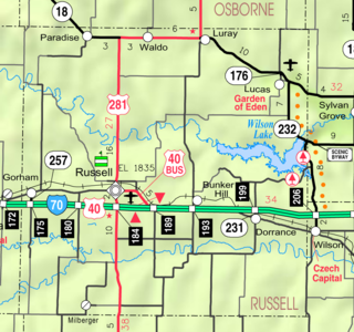
Fairport is an unincorporated community in Paradise Township, Russell County, Kansas, United States. It is located about 12 miles north of Gorham near the west county line and next the Saline River.

Black Wolf is an unincorporated community in Ellsworth County, Kansas, United States. It is approximately 6 miles (9.7 km) west of Ellsworth.
Kickapoo is an unincorporated community in Kickapoo Township, Leavenworth County, Kansas, United States. It is part of the Kansas City metropolitan area.
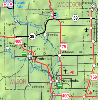
Lafontaine is an unincorporated community in Wilson County, Kansas, United States. As of the 2020 census, the population of the community and nearby areas was 58. It is located south of Fredonia and west of Neodesha.

Vesper is an unincorporated community in Lincoln County, Kansas, United States. It is located about 7 miles (11 km) west of Lincoln.

Haverhill is an unincorporated community in Butler County, Kansas, United States. It is located about 4.5 miles (7.2 km) east of Augusta.
Ransomville is an unincorporated community in Franklin County, Kansas, United States. It is located approximately 2 miles northeast of Williamsburg at the intersection of U.S. 50 highway and Hamilton Road.
Homewood is a unincorporated community in Homewood Township, Franklin County, Kansas, United States. In the 19th century it had a post office and a stop on the Atchison, Topeka, and Santa Fe Railway.
Vine Creek is a ghost town in Ottawa County, Kansas, United States.

Turkville is a ghost town in Ellis County, Kansas, United States.

Webster was an unincorporated community in Belmont Township, Rooks County, Kansas, United States.
Deliverance is a ghost town in Mt Ayr Township, Osborne County, Kansas, United States.
Milo is a ghost town in Lincoln County, Kansas, United States. It was located along a former railroad about half way between the communities of Barnard and Ada.
Pansy was a hamlet in Franklin County, Kansas, United States. It was situated in the Appanoose Creek valley in the north-west of the county.


