Franklin County is a county located in the eastern portion of the U.S. state of Kansas. Its county seat and most populous city is Ottawa. As of the 2020 census, the county population was 25,996. The county was named for Benjamin Franklin, a founding father of the United States. Formerly it was considered part of the Kansas City metropolitan area, but was removed in 2013.

Home is an unincorporated community in southern Franklin Township, Marshall County, Kansas, United States. As of the 2020 census, the population of the community and nearby areas was 154. It lies along U.S. Route 36 – the Pony Express Highway – and a Union Pacific rail line, east of the city of Marysville.

Xenia is an unincorporated community in Franklin Township, Bourbon County, Kansas, United States.

The 2004 United States Senate election in Oklahoma took place on November 2, 2004. The election was concurrent with elections to the United States House of Representatives and the presidential election. Incumbent Republican U.S. Senator Don Nickles decided to retire instead of seeking a fifth term. Republican nominee Tom Coburn won the open seat.
The North Branch Dead River is a 19.3-mile-long (31.1 km) tributary of the Dead River in Franklin County, Maine. It is paralleled by Maine State Route 27.

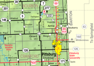
Franklin is an unincorporated community in Crawford County, Kansas, United States. As of the 2020 census, the population of the community and nearby areas was 473. Franklin is located along U.S. Route 69, 1 mile (1.6 km) south of Arma, or 5.9 miles (9.5 km) north of Frontenac.

Richter is an unincorporated community in Franklin County, Kansas, United States.

Foster Dwight Coburn was an American farmer and statesman. He served as secretary of the Kansas Department of Agriculture.
Peoria is an unincorporated community in Franklin County, Kansas, United States.
Imes is an unincorporated community in Franklin County, Kansas, United States. It is located southeast of Ottawa at about 4 miles south of K-68 on Tennessee Road

Norwood is a ghost town in north Franklin County, Kansas, United States. It is located approximately 1.25 miles (2.01 km) east of U.S. Route 59 on Stafford Rd, and 2 miles (3.2 km) south of the Franklin-Douglas county line.
Ransomville is an unincorporated community in Franklin County, Kansas, United States. It is located approximately 2 miles northeast of Williamsburg at the intersection of U.S. 50 highway and Hamilton Road.
Homewood is an unincorporated community in Franklin County, Kansas, United States.

Centropolis is an unincorporated community in Franklin County, Kansas, United States. As of the 2020 census, the population of the community and nearby areas was 100. It is located about 11 miles northwest of Ottawa. In the 1850s, Centropolis had the distinction of briefly vying for territorial capital of Kansas.
Birmingham is an unincorporated community in Franklin Township, Jackson County, Kansas, United States.
Franklin is a ghost town in Douglas County, Kansas, United States. Established as a proslavery stronghold, the town played a key role in the "Bleeding Kansas" conflict that troubled the territory in the 1850s.

Terra Cotta is a ghost town in Ellsworth County, Kansas, United States.

Appanoose is a ghost town in Franklin County, Kansas, United States.

Forest Home is a ghost town in Franklin County, Kansas, United States.

Pansy is a ghost town in Franklin County, Kansas, United States.


