
Madison County is a county located in the central part of the U.S. state of Kentucky. At the 2020 census, its population was 92,701. Its county seat is Richmond. The county is named for Virginia statesman James Madison, who later became the fourth President of the United States.

Riley County is a county located in the U.S. state of Kansas. Its county seat and largest city is Manhattan. As of the 2020 census, the population was 71,959. The county was named after Bennet Riley, the 7th governor of California, and a Mexican–American War hero. Riley County is home to Fort Riley and Kansas State University.

Linn County is a county in the U.S. state of Kansas, located in along the eastern edge of Kansas, and is part of the Kansas City metropolitan area. Its county seat is Mound City, and its most populous city is Pleasanton. As of the 2020 census, the county population was 9,591. The county was named for Lewis Linn, a U.S. Senator from Missouri.

Franklin County is a county located in the eastern portion of the U.S. state of Kansas. Its county seat and most populous city is Ottawa. As of the 2020 census, the county population was 25,996. The county was named for Benjamin Franklin, a founding father of the United States. Formerly it was considered part of the Kansas City metropolitan area, but was removed in 2013.
Berea is a home rule-class city in Madison County, Kentucky, in the United States. The town is best known for its art festivals, historic restaurants and buildings, and as the home to Berea College, a private liberal arts college. The population was 15,539 at the 2020 census. It is one of the fastest-growing towns in Kentucky, having increased by 27.4% since 2000. Berea is a principal city of the Richmond−Berea Micropolitan Statistical Area, which includes Madison and Rockcastle counties. It was formally incorporated by the state assembly in 1890.
Eureka Township is one of the seventeen townships of Adair County, Iowa, United States. At the 2020 census, its population was 101.
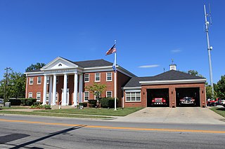
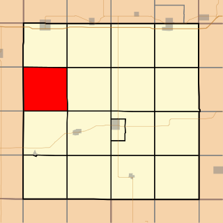
Richmond Township is a township in Franklin County, Kansas, USA. As of the 2000 census, its population was 812.

LeLoup is an unincorporated community in Franklin County, Kansas, United States. It is located a mile and half north of Interstate 35 on Tennessee Road, 11 miles northeast of Ottawa, 7 miles southwest of Wellsville.

Franklin is an unincorporated community in Crawford County, Kansas, United States. As of the 2020 census, the population of the community and nearby areas was 473. Franklin is located along U.S. Route 69, 1 mile (1.6 km) south of Arma, or 5.9 miles (9.5 km) north of Frontenac.
Richter is an unincorporated community in Franklin County, Kansas, United States.

Kentucky Route 595 is a north- south route running through Madison County, Kentucky, United States. Its northern terminus is at the Kentucky River near Valley View and it southern terminus is at the intersection of Kentucky Route 1617 2 miles south of Berea. From the northern terminus to its intersection with Kentucky Route 876 it follows Silver Creek.
Spindletop is a rural neighborhood north of Lexington, Kentucky, United States. Its boundaries are I-75 to the west and Berea Road to the south and east. It is located just south of the Kentucky Horse Park. It is named for Spindletop hall, a historic mansion once owned by Miles Franklin Yount, which is located within the neighborhood.
Peoria is an unincorporated community in Franklin County, Kansas, United States.
Imes is an unincorporated community in Franklin County, Kansas, United States. It is located southeast of Ottawa at about 4 miles south of K-68 on Tennessee Road
Norwood is a ghost town in north Franklin County, Kansas, United States. It is located approximately 1.25 miles (2.01 km) east of U.S. Route 59 on Stafford Rd, and 2 miles (3.2 km) south of the Franklin-Douglas county line.
Ransomville is an unincorporated community in Franklin County, Kansas, United States. It is located approximately 2 miles northeast of Williamsburg at the intersection of U.S. 50 highway and Hamilton Road.
Homewood is an unincorporated community in Franklin County, Kansas, United States.
Centropolis is an unincorporated community in Franklin County, Kansas, United States. As of the 2020 census, the population of the community and nearby areas was 100. It is located about 11 miles northwest of Ottawa. In the 1850s, Centropolis had the distinction of briefly vying for territorial capital of Kansas.
Clover Bottom is an unincorporated community located in northern Jackson County, Kentucky, United States. The community is located along US 421 at its intersection with Kentucky Route 1955. It is 3.4 miles northwest of Sandgap and 9.3 miles southeast of Berea. The community is addressed to McKee's ZIP code 40447, despite being past Sandgap, which has its own post office with ZIP code 40481, which partially serves the area around Clover Bottom.
Ohio City is a ghost town in Franklin County, Kansas, United States.


