Pointe de Givet National Nature Reserve

Last updated
Pointe de Givet National Nature Reserve
Voie verte Givet 2.JPG
Fort de Charlemont et Porte de France
Location Ardennes, France
Nearest city Givet
Coordinates 50°06′46″N4°48′18″E / 50.11278°N 4.80500°E / 50.11278; 4.80500
Area354 ha
EstablishedMarch 4, 1999
Governing bodyConservatoire d'espaces naturels de Champagne-Ardennes
ONF Ardenne

The Pointe de Givet National Nature Reserve (RNN145) is a national nature reserve of the Grand Est region of France. Established in 1999, it spreads over 354 hectares and protects a group of sites recognised for their rich geology, flora and fauna.

Contents

Localisation

At the northern end of the Ardennes department, the nature reserve territory consists of 11 entities localized on the communes of Charnois, Chooz, Foisches, Fromelennes, Givet, and Rancennes for a total area of 354 hectares. [1]

History of site and reserve

Perimeter of the Pointe de Givet National Nature Reserve Perimetre RNN Pointe de Givet rnn145.png
Perimeter of the Pointe de Givet National Nature Reserve

The sector has been known by naturalists since at least the 19th century for its geological riches and flora. To protect this deteriorating heritage, "La Valenne" association solicited the classification as national nature reserve of the most notable natural environments of the site known as Pointe de Givet in 1990. The classification procedure succeeded in 1999, and governing bodies (National Forests Office and Conservatory of Natural Areas of Champagne-Ardennes (Conservatoire d'espaces naturels de Champagne-Ardennes)) have been designed in 2000. [2]

Ecology

The nature reserve offers a landscape composed of forests, moors, dry lawns as well as spectacular rocky escarpments. Its interest is geological, floral and faunal. Five main natural habitat types can be found:

Geology

Givet Pointe's geology presents several unusual aspects. Of educational interest, they justify national nature reserve classification. The Meuse valley deeply cuts into limestone and it is here that Jules Gosselet defined the Givétien stratotype in 1879. But rocks diversity is broad; in addition to a limestone known as Givet blue stone  [ fr ], there are shales, sandstones, an old fluorite quarry and many fossils, notably trilobites. [4] Some limestone caves complete the inventory with their stalactites and stalagmites.

Flora

The geographical location of Givet Pointe, with the spectacular relief of certain sites, and the existence of hot and dry micro-climates, have allowed the development of a southern flora which is exceptional at this latitude. The nature reserve flora inventory reports 461 species, including 156 remarkable ("rare" or "very rare") among which 11 are protected in Champagne-Ardenne. The Regional Red List has 35 registered species such as white mugwort ( Artemisia alba ), the wild cotoneaster, cat's-foot, monkey orchid and bloody geranium. [1] [5]

Fauna

A Eurasian eagle-owl Eurasian eagle-owl (44088).jpg
A Eurasian eagle-owl

The variety of natural environments provides habitats for more than 320 animal species, including insects, bats and birds. [5]

Twenty mammal species have been identified. The richness in insects and existence of caves explain the presence of 12 species of bats, some of which fall under the Habitats Directive (92/43/EEC): lesser horseshoe bat, greater horseshoe bat, greater mouse-eared bat and Geoffroy's bat. [1]

Over 70 species of birds have been identified , a third of which are registered on the Regional Red List, such as the Eurasian eagle-owl, European nightjar and woodlark. [1]

Reptiles like the common European adder and the smooth snake are fond of rocky areas. [5]

As of 2020, 171 insect species have thus far been identified, including 78 Lepidoptera Papilionoidea such as Erebia medusa , the silver-studded blue, large copper and the marsh fritillary. [3] There are also around 30 species of Orthoptera such as the blue-winged grasshopper, the grey bush cricket, the Tetrix bipunctata and the wart-biter. [5]

State, pressures or threats, responses

The nature reserve splitting into 11 entities leads to significant ecological fragmentation. Numerous after-effects of war dot the territory. In the absence of large wild herbivorous mammals, there is a tendency for open areas to become overgrown.

Tourism and educational interest

France's Gate at Givet Givet - Porte de France.jpg
France's Gate at Givet
Former watchtower, known as "Gregoire tower" located on the edge of the abrupt of the Mount d'Haurs, above the Meuse valley. It would have been erected in the 11th century, but has undergone multiple transformations. The visitor can discover from there a large part of the panorama of the Meuse valley Givet tower.jpg
Former watchtower, known as "Grégoire tower" located on the edge of the abrupt of the Mount d'Haurs, above the Meuse valley. It would have been erected in the 11th century, but has undergone multiple transformations. The visitor can discover from there a large part of the panorama of the Meuse valley

It is linked to natural habitats, landscapes (steep gradients) and biodiversity they shelter, but also to geological riches of the site and its cultural aspects. Givet Point is an old traffic area of strategic interest that has left its mark:

The site has become a centre of environmental education, offering trails, guided tours and study facilities. [5]

Administration, management plan, regulations

The management is ensured by the Conservatory of Natural Spaces of Champagne-Ardenne (Conservatoire d'espaces naturels de Champagne-Ardenne) and the National Forests Office Ardennes (ONF Ardennes). The first management plan (2003-2007) enabled restoration work (reopening of dry lawns) thanks to brushcutting and mowing with export made by students, reintegration teams or "nature work camps". Goats have been used since 2005 to remove the bushes from part of the "Aviette Maurière ravines" by extensive grazing. An evaluation of the management plan was started in 2007. The second management plan 2008-2012 is completed.

The nature reserve was classified in application of the law of July 10, 1976, by a decree of March 4, 1999. [6] Several protection perimeters overlap there: registered and classified sites, ZNIEFF types I and II, ZICO, ZSC and APPB.

Related Research Articles

<span class="mw-page-title-main">Givet</span> Commune in Grand Est, France

Givet is a commune in the Ardennes department in northern France surrounded on three sides by the Belgian border. It lies on the river Meuse where Emperor Charles V built the fortress of Charlemont. It borders the French municipalities of Fromelennes to the east and Rancennes to the south and Foisches to the southeast.

<span class="mw-page-title-main">Awala-Yalimapo</span> Commune in French Guiana, France

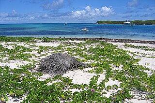
Awala-Yalimapo is a commune on the north coast of French Guiana, close to the border with Suriname. The seat of the commune is the settlement of Awala where the town hall is located. Other settlements in the commune are: Yalimapo, Ayawande, and Piliwa. The majority of the inhabitants are Kaliña Amerindian people.

<span class="mw-page-title-main">Chooz, Ardennes</span> Commune in Grand Est, France

Chooz is a commune in the Ardennes department in northern France.

<span class="mw-page-title-main">Carrière des Nerviens Regional Nature Reserve</span> Protected area in the Nord-Pas-de-Calais region of France

The Carrière des Nerviens Regional Nature Reserve is a protected area in the Nord-Pas-de-Calais region of northern France. It was established on 25 May 2009 to protect a site containing rare plants and covers just over 3 hectares. It is located in the municipalities of Bavay and Saint-Waast in the Nord department.

<span class="mw-page-title-main">Zone naturelle d'intérêt écologique, faunistique et floristique</span>

A Zone naturelle d'intérêt écologique, faunistique et floristique, abbreviated as ZNIEFF, is a type of natural environment recognized by France.

<span class="mw-page-title-main">Petite Terre Islands National Nature Reserve</span>

Petite Terre Islands National Nature Reserve is a reserve of the Petite Terre Islands in Guadeloupe. The reserve was established by Decree No. 98-801 of 3 September 1998 as the nature reserve for the islands of Petite Terre. It covers an area of about 990 hectares, which is demarcated by five points fixed with buoys, and includes a land area of 148.6 hectares with the balance as sea area.

<span class="mw-page-title-main">Pointe de Givet</span>

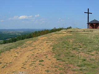
The pointe de Givet is the extreme north of the department of Ardennes in the Grand Est region in northeastern France. This small territory is 25 km in length and 10 km wide and forms a small strip extending deep into Belgian Ardennes along the Meuse. Larger cities in the pointe de Givet include Revin, Fumay, and Givet.

A national nature reserve, in French réserve naturelle nationale, (RNN) is a protected area that is part of natural reserves of France (RNF) and whose status is defined by the law on local democracy of February 27, 2002. It is a tool for the long-term protection of spaces, species or geological objects. The duration of its protection is unlimited.

<span class="mw-page-title-main">Vireux-Molhain National Nature Reserve</span>

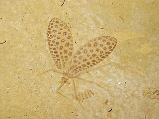
The Vireux-Molhain national nature reserve (RNN104) is a national nature reserve of geological and paleontological interest. It is located in the Pointe de Givet, department of Ardennes, on the border between France and Belgium. It covers an area of 1.82 ha. The site is known as Customs Wall as it is near an old customs post. This outcrop of Middle Devonian shale is notable for the quantity and good state of preservation of its fossils. Trilobites are well-represented.

<span class="mw-page-title-main">Forêt d'Orient National Nature Reserve</span>

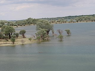
The Forêt d'Orient National Nature Reserve (RNN154) is a national nature reserve located in Champagne-Ardenne in the Grand Est region in France. Located within the Orient Forest Regional Natural Park, it was created in 2002 and protects 1,560 hectares of lake and forest areas.

<span class="mw-page-title-main">Petites Montagnes Tortue Biological Reserve</span> Wilderness area in French Guiana

The Petites Montagnes Tortue Biological Reserve is a wilderness area in French Guiana, France. Petites Montagnes Tortue is located about six kilometres from Régina. It is a mountain range rich in quartz and quartzites with a summit of 287 metres (942 ft). The mountains are home to a diverse flora and fauna with about 20 species which are rare or endemic.

The Récif fossile de Marchon - Christian Gourrat Regional Nature Reserve (RNR284) is a Regional Nature Reserve located in Auvergne-Rhône-Alpes. Established in 2015, it spreads over 0.1 hectares and protects a limestone outcrop bearing fossils from the Mesozoic era.

<span class="mw-page-title-main">Bois du Parc National Nature Reserve</span> Regional nature reserve and fossil site in Auvergne-Rhône-Alpes, France

The Bois du Parc National Nature Reserve (RNN39) is a National Nature Reserve located in the department of Yonne. Established in 1979, it spreads over 45 ha, and its most interesting features are its steep-sided cliffs in an important coral reef dating from the Jurassic era.

<span class="mw-page-title-main">Géologique du Luberon National Nature Reserve</span> Regional nature reserve and fossil site in Provence-Alpes-Côte dAzur, France

The Géologique du Luberon National Nature Reserve (RNN90) is a national nature reserve located in Provence-Alpes-Côte d'Azur. Established in 1987, it occupies 312 hectares and protects 28 scattered geological sites dated from the Cenozoic.

<span class="mw-page-title-main">Géologique de Normandie-Maine Regional Nature Reserve</span> Regional nature reserve and fossil site in Normandie, France

The Géologique de Normandie-Maine Regional Nature Reserve (RNR216) is a geological regional nature reserve located in the Normandie region. Established in 2009, it spreads over 0.37 hectares and protects an extraction site of Ordovician limestone, renowned for its microfossils of conodonts. By its size, it is the third smallest regionale nature reserve in France.

The Géologique de Pontlevoy Regional Nature Reserve is a regional nature reserve located in the Centre-Val de Loire region of France. Established in 2011, it spreads over 1.91 hectares and protects a former Beauce limestone quarry preserving faluns.

<span class="mw-page-title-main">Parc naturel régional de la Martinique</span> A regional nature park in Martinique

Parc naturel régional de la Martinique is one of 54 French regional nature parks. With a surface area of approximately 63,000 ha (240 sq mi), it covers more than half of the island, overlapping 32 of 34 communes - including approximately 100,000 inhabitants. The park works to preserve one of 34 biodiversity hotspots on the planet. The biodiversity hotspot map identifies areas for preservation by two criteria, one being a certain rate of endemism: that the flora and fauna are not found elsewhere, and because at least 70% of its primary vegetation has been lost.

<span class="mw-page-title-main">Toarcien National Nature Reserve</span> Regional nature reserve and fossil site in Nouvelle-Aquitaine, France

The Toarcien National Nature Reserve (RNN91) is a French national nature reserve located in Nouvelle-Aquitaine, near the city of Thouars, from which the name Toarcian is derived. Established in 1987, it occupies an area of 0.61 hectares, making it the smallest national nature reserve in France. It protects two former quarries preserving the stratotype of the Toarcian stage.

<span class="mw-page-title-main">Bastberg Hill</span> Mountain in France

The Bastberg, also called Petit-Bastberg, is a summit located near the Northern Vosges Regional Nature Park, in the commune of Bouxwiller. It culminates at 326 meters. The ecosystem is fragile due to human and natural intrusions, and has been the subject of conservation measures since 1989.

References

Main source: Réserves Naturelles de France, and Lettre des réserves naturellesno 92 (4th trimester 2007).

  1. 1 2 3 4 "Pointe de Givet". Réserves naturelles de France.
  2. "Réserve Naturelle Nationale Pointe de Givet - Plan de gestion 2019-202 8" (PDF). DREAL Grand Est (in French). Retrieved 29 January 2020.
  3. 1 2 "Réserve Naturelle Nationale de la Pointe de Givet". Conservatoire d'espaces naturels Champagne-Ardenne (in French). 2020. Retrieved 29 January 2020.
  4. Jonin, Max (2006). Mémoire de la Terre: Patrimoine géologique français. Delachaux et Niestlé. ISBN   2-603-01383-1.
  5. 1 2 3 4 5 "Plaquette RN Pointe de Givet" (PDF). RNF.
  6. "Décret n°99-154 du 4 mars 1999 portant création de la réserve naturelle de la pointe de Givet (Ardennes)". Legifrance.