Pointe de Paumont

Last updated
Pointe de Paumont
Cima del Vallone
Cima del vallone da punta bagna.jpg
The mountain seen from Punta Bagnà
Highest point
Elevation 3,171 m (10,404 ft) [1]
Prominence 378 m (1,240 ft) [1]
Parent peak Aiguille de Scolette [2]
Isolation 3.21 km (1.99 mi)  OOjs UI icon edit-ltr-progressive.svg
Listing Alpine mountains above 3000 m
Coordinates 45°08′21″N06°43′41″E / 45.13917°N 6.72806°E / 45.13917; 6.72806 Coordinates: 45°08′21″N06°43′41″E / 45.13917°N 6.72806°E / 45.13917; 6.72806 [1]
Geography
Alps location map.png
Red triangle with thick white border.svg
Pointe de Paumont
Location in the Alps
Location Rhône-Alpes, France
Piedmont, Italy
Parent range Cottian Alps
Climbing
Easiest route from Pelouse pass (E ridge) or Roccia Verde pass (S ridge)

Pointe de Paumont (in French) or Cima del Vallone (in Italian) is a mountain of Savoie, France and of the Province of Turin, Italy. It lies in the Cottian Alps range. It has an elevation of 3,171 metres above sea level.

Contents

Etymology

Paumort, the name used on French maps, should come from a toponym used on the Italian side of the mountain (croce di Paumont, rio di Paumont), which derives from Piedmontese "pàu mòrt" («fear of death»). [3]

Geography

In the French subdivision of Western Alps it belongs to the Massif du Mont-Cenis while in the SOIUSA (International Standardized Mountain Subdivision of the Alps) it' the highest mountain of a subgroups (STG) called Crête Grand Vallon-pointe du Fréjus ( Fr) or Cresta Gran Vallone-punta del Fréjus (It) - code:I/A-4.III-B.5.a. [4]

Administratively the mountain is divided between the commune of Avrieux (F, north face) and the comune of Bardonecchia (I, south-western and south-eastern faces).

Access to the summit

Eastern side of the summit. Cima vallone da est.jpg
Eastern side of the summit.

The easiest route for the summit starts from Pelouse's pass, which connects Avrieux and Bardonecchia, and follows the eastern ridge of the mountain passing by Cime Gardoria/Cima Gardiola (3,137 m). Other two routes, roughly of the same climbing grade, follow the other two ridges which meet on the mountain's summit: the southern one from Roccia Verde pass and the northwestern one from Punta Bagnà. [3]

Notes

  1. 1 2 3 Géoportail IGN on www.geoportail.fr
  2. key col: Col de Pelouse
  3. 1 2 Aruga, Roberto; Pietro Losana; Alberto Re (1985). Alpi Cozie settentrionali. Guida ai monti d'Italia (in Italian). Club Alpino Italiano.
  4. Marazzi, Sergio (2005). Atlante Orografico delle Alpi. SOIUSA (in Italian). Priuli & Verlucca. p. 90. ISBN   978-88-8068-273-8.

Maps

Commons-logo.svg Media related to Cima del Vallone at Wikimedia Commons

Related Research Articles

Aiguille de Scolette Mountain in Italy

Aiguille de Scolette or Pierre Menue is a mountain of Savoie (F) and of the province of Turin (I). It lies in the Cottian Alps and has an elevation of 3,506 metres above sea level.

Punta BagnĂ  Mountain in Italy

Punta Bagnà or Cime du Grand Vallon is a mountain of Savoie, France and of the Province of Turin, Italy. It lies in the Cottian Alps range. It has an elevation of 3,129 metres above sea level.

Punta Sommeiller Mountain in Italy

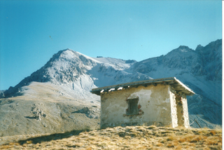
Punta Sommeiller or Pointe Sommeiller is a mountain of the Province of Turin, Italy and of Savoie, France. It lies in the Cottian Alps range. It has an elevation of 3,333 metres (10,935 ft) above sea level.

Monte Bo Mountain in Italy

Monte Bo is a mountain in the Alpi Biellesi, a sub-range of Pennine Alps.

Rognosa dEtiache Mountain in Italy

Rognosa d'Etiache or Rognosa d'Étache is a mountain in the Cottian Alps on the border of Turin, Italy, and Savoie, France. It has an elevation of 3,382 metres above sea level.

Punta Ramiere Mountain in Italy

The Punta Ramiere or Bric Froid is a mountain in the Cottian Alps belonging to the department of Hautes-Alpes (FR) and the province of Turin (IT). It's the highest peak of the long stretch of the Po/Rhone water divide starting from the Aiguille de Scolette (north) and ending with the Monviso group (south).

Punta Marguareis Mountain in Italy

The Punta Marguareis (It) or Pointe Marguareis (Fr) is a mountain in the Ligurian Alps, on the boundary between Italy and France; It is the highest peak of the Ligurian Alps.

Cima di PertegĂ  Mountain in Italy

Cima di Pertegà (Italian) or Cime de la Pertègue (French) is a mountain located on the French-Italian border between Piemonte and Provence-Alpes-Côte d'Azur.

Cime de Capoves Mountain in Italy

The Cime de Capoves (French) or Cima Capoves (Italian) is a mountain of the Ligurian Alps located in the French region of Provence-Alpes-Côte d'Azur, close to the French-Italian border.

Punta Merciantaira Mountain in Italy

The Punta Merciantaira or Grand Glaiza is a 3,293 metres high mountain of the Cottian Alps.

Grand Queyron Mountain in Italy

The Gran Queyron or Grand Queyron is a 3,060 metres high mountain of the Cottian Alps.

Punta Leynir Mountain in Italy

The Punta Leynir is a 3,238 metres high mountain belonging to the Italian side of Graian Alps.

Mongioia Mountain in Italy

The Cima Mongioia or simply Mongioia or Bric de Rubren is a 3,340 metres high mountain of the Cottian Alps.

Punta Nera Mountain in Italy

The Punta Nera is a mountain of Savoie (France) and of the Province of Turin (Italy). It lies in the Cottian Alps range. It has an elevation of 3,047 metres above sea level.

Pointe Rochers Charniers Mountain in France

The Pointe Rochers Charniers is a mountain of the Cottian Alps at an elevation of 3,063 metres above sea level, located in France.

Monte Bertrand Mountain in Italy

Monte Bertrand (Italian) or Mont Bertrand (French) is a mountain located on the French-Italian border between Piemonte and Provence-Alpes-Côte d'Azur.

Cime de Missun Mountain in Italy

The Cime de Mussun (French) or Cima Missun (Italian) is a mountain of the Ligurian Alps.

Cima della Fascia Mountain in Italy

The Cima della Fascia is a mountain of the Ligurian Alps located in Piedmont.

Cima Cars Mountain in Italy

The Cima Cars is a mountain of the Ligurian Alps located in Piedmont.

Mont Froid Mountain in France

The Mont Froid is a 2,822 m high mountain of the northern Cottian Alps.