Ahlmann Ridge, also known as Ahlmannryggen, is a broad, mainly ice-covered ridge, about 110 km (70 mi) long, surmounted by scattered, low peaks. It rises between Schytt Glacier and Jutulstraumen Glacier and extends from Borg Massif northward to Fimbul Ice Shelf in Queen Maud Land. The area was first photographed from aircraft of the Third German Antarctic Expedition (1938–39) and peaks in this vicinity were roughly plotted. The Stein Nunataks and Witte Peaks, named by the German Antarctic Expedition, appear to coincide with the northeast part of the Ahlmann Ridge. The feature was mapped in detail from surveys and air photos by the Norwegian-British-Swedish Antarctic Expedition (NBSAE) (1949–1952) and air photos by the Norwegian expedition (1958–59). Named for Hans Wilhelmsson Ahlmann, chairman of the Swedish committee for the NBSAE.

Flask Glacier, is a gently-sloping glacier, 25 nautical miles long, flowing east from Bruce Plateau to enter Scar Inlet between Daggoo Peak and Spouter Peak in Graham Land, Antarctica. The lower reaches of this glacier were surveyed and photographed by the Falklands Islands Dependencies Survey (FIDS) in 1947. The entire glacier was photographed by the Falkland Islands and Dependencies Aerial Survey Expedition in 1955–56, and mapped by the FIDS in 1957. It was named by the UK Antarctic Place-names Committee after the third mate on the Pequod in Herman Melville's Moby-Dick; or, The White Whale.
Christophersen Glacier is a glacier 8 nautical miles (15 km) long, flowing west into Jacobsen Bight on the south coast of South Georgia. It was surveyed by the South Georgia Survey in the period 1951–57, and named by the UK Antarctic Place-Names Committee for Pedro Christophersen, one of the first Directors of the Compañía Argentina de Pesca which operated the Grytviken whaling station for more than 50 years beginning in 1904.
Cape Bruce forms the northern tip of a small island lying at the eastern side of Oom Bay, separated from the mainland rocks just west of Taylor Glacier in Mac. Robertson Land, Antarctica.
Andenes Knoll is the southeasternmost knoll in a group of three knolls in the Weddell Sea, the other two being Explora Knoll and Polarstern Knoll. It was named for the Norwegian coast-guard vessel K.V. Andenes, the name being proposed by Dr. Heinrich Hinze of the Alfred Wegener Institute for Polar and Marine Research, Bremerhaven, Germany, and approved by the Advisory Committee on Undersea Features in June, 1997.
The Bennett Nunataks are two rock nunataks 0.5 nautical miles (1 km) apart, lying 0.5 nautical miles north of Lackey Ridge in the Ohio Range of the Horlick Mountains. They were surveyed by the United States Antarctic Research Program Horlick Mountains Traverse party in December 1958, and named by the Advisory Committee on Antarctic Names for John B. Bennett, a geomagnetist-seismologist at Byrd Station, 1960.
The Byvågåsane Peaks are three low aligned rock peaks which surmount the east shore of Byvågen Bay on the east side of Lutzow-Holm Bay. They were mapped by Norwegian cartographers from air photos taken by the Lars Christensen Expedition, 1936–37 and named Byvågåsane in association with Byvågen Bay.

The Gruber Mountains are a small group of mountains consisting of a main massif and several rocky outliers, forming the northeast portion of the Wohlthat Mountains in Queen Maud Land, Antarctica. They were discovered and plotted from air photos by the Third German Antarctic Expedition (GerAE), 1938–39, under Alfred Ritscher. The mountains were remapped by the Sixth Norwegian Antarctic Expedition, 1956–60, who named them for Otto von Gruber, the German cartographer who compiled maps of this area from air photos taken by the GerAE. This feature is not to be confused with "Gruber-Berge," an unidentified toponym applied by the GerAE in northern the Mühlig-Hofmann Mountains.
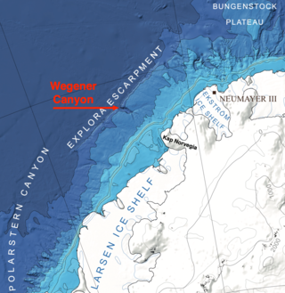
Wegener Canyon is a submarine canyon named for Alfred Wegener. It is located between Kap Norvegia and the Explora Escarpment as a feature for sediment transport at the Antarctic continental margin. The Canyon was mapped during various expeditions of the German research vessel RV Polarstern with a swath sonar system. The name was proposed by Hans Werner Schenke, Alfred Wegener Institute for Polar and Marine Research, Bremerhaven, Germany. Name approved 7/89.

Coulter Glacier is a steeply inclined glacier, 5 nautical miles (9 km) long, flowing south from the Havre Mountains, northern Alexander Island, into Kolokita Cove in Lazarev Bay, Antarctica. The glacier was photographed from the air by the Ronne Antarctic Research Expedition in 1947 and mapped from the photographs by the Falkland Islands Dependencies Survey in 1960. It was named by the Advisory Committee on Antarctic Names for R.W. Coulter, Master of USNS Alatna during U.S. Navy Operation Deepfreeze, 1969.
Planet Heights is a series of summits running along an ice-free ridge, extending 24 nautical miles (44 km) in a north-south direction between the southernmost extremity of the LeMay Range and George VI Sound in the east part of Alexander Island, Antarctica. Many landforms and nearby features are named in association with this mountain range; some of these include landforms named after astronomers, satellites, planets and other things related to astrology and astrophysics. The mountain range was first mapped from air photos taken by the Ronne Antarctic Research Expedition (RARE), 1947–48, by Searle of the Falkland Islands Dependencies Survey (FIDS) in 1960. Named by the United Kingdom Antarctic Place-Names Committee (UK-APC) from association with the nearby glaciers named for planets of the Solar System. The only planet that is not featured in any of these glaciers is the planet Earth, as there are no glaciers named "Earth Glacier" and this glacier does not exist.
Polarstern Canyon is an undersea canyon named for the German research vessel Polarstern, which took part in 22 expeditions to the Arctic and Antarctic (1982–1995). Name proposed by Dr. Heinrich Hinze, Alfred Wegener Institute for Polar and Marine Research, Bremerhaven, Germany. Name approved 6/97.
Erratic Valley is a short valley on Alexander Island, Antarctica, that joins Ablation Valley from the north. It was named from the large number of erratic igneous blocks observed in the valley by a University of Aberdeen field party which mapped the area in 1978–79. The site lies within Antarctic Specially Protected Area (ASPA) No.147.
Fowler Knoll is a notable snow-covered knoll, 2,465 metres (8,090 ft) high, with an abrupt south-facing cliff, in the west-central part of the Havola Escarpment, Antarctica. It was mapped by the United States Geological Survey from surveys and U.S. Navy air photos, 1958–61, and was named by the Advisory Committee on Antarctic Names for Chief Warrant Officer George W. Fowler, US Army, a navigator on the 700 nautical miles (1,300 km) tractor traverse from Byrd Station to South Pole Station, December 8, 1960 to January 11, 1961. The tractor party, led by Major Antero Havola, passed a few miles northward of this knoll on December 25, 1960.
Mount Geissel is a mountain, 1,430 metres (4,700 ft) high, standing 3 nautical miles (6 km) south of Mount Simmons in the Independence Hills of the Heritage Range, Antarctica. It was named by the Advisory Committee on Antarctic Names for Robert H. Geissel, a United States Antarctic Research Program geomagnetist and seismologist at Plateau Station in 1966.

Henderson Glacier is a glacier approximately 7 nautical miles long in the Enterprise Hills of the Heritage Range, Antarctica. It flows northeast from Schoeck Peak and Hoinkes Peak to enter Union Glacier just east of Mount Rossman. Henderson Glacier was mapped by the United States Geological Survey from surveys and U.S. Navy air photos 1961–66, and was named by the Advisory Committee on Antarctic Names for Felix E. Henderson, a United States Antarctic Research Program meteorologist at Eights Station in 1965.
Hovdeskar Gap is a gap just east of Mount Skarshovden at the head of Skarsbrotet Glacier, in the Humboldt Mountains of Queen Maud Land, Antarctica. It was discovered and photographed by the Third German Antarctic Expedition, 1938–39, was mapped by Norway from air photos and surveys by the Sixth Norwegian Antarctic Expedition, 1956–60, and named Hovdeskar.
Lundström Knoll is a rock knoll rising to about 1,400 metres (4,600 ft) to the northeast of the Chevreul Cliffs in Pioneers Escarpment, Shackleton Range, Antarctica. It was photographed from the air by the U.S. Navy, 1967, and surveyed by the British Antarctic Survey, 1968–71. The knoll was named by the UK Antarctic Place-Names Committee in association with the names of pioneers of polar life and travel grouped in this area, after Johan E. Lundström, the Swedish inventor of the first true "strike-on-box safety match" in 1855.
