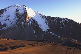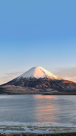
Parinacota, Parina Quta or Parinaquta is a dormant stratovolcano on the border of Bolivia and Chile. Together with Pomerape it forms the Nevados de Payachata volcanic chain. Part of the Central Volcanic Zone of the Andes, its summit reaches an elevation of 6,380 metres (20,930 ft) above sea level. The symmetrical cone is capped by a summit crater with widths of 1 kilometre (0.62 mi) or 1,000 metres (3,300 ft). Farther down on the southern slopes lie three parasitic centres known as the Ajata cones. These cones have generated lava flows. The volcano overlies a platform formed by lava domes and andesitic lava flows.

Payachata or Paya Chata is a north–south trending complex of potentially active volcanos on the border of Bolivia and Chile, directly north of Chungará Lake. The complex contains two peaks, Pomerape to the north and Parinacota to the south. On the Bolivian side the volcanoes are located in the Oruro Department, Sajama Province, Curahuara de Carangas Municipality, and on the Chilean side they lie in the Arica y Parinacota Region, Parinacota Province.

Cerro Bayo is a complex volcano on the northern part border between Argentina and Chile. It consists of four overlapping stratovolcanoes along a north–south line. The main volcano face is located on the Argentine side, thought the summit of the complex is just west of the border, in Chile. The volcano is about 800,000 years old, but it is associated with ongoing ground uplift encompassing also the more northerly Lastarria and Cordón del Azufre volcanoes. The 5,401-metre (17,720 ft) high summit is the source of two viscous dacitic lava flows with prominent levees that traveled to the north.

Calbuco is a stratovolcano in southern Chile, located southeast of Llanquihue Lake and northwest of Chapo Lake, in the Los Lagos Region, and close to the cities of Puerto Varas and Puerto Montt. With an elevation of 2,015 meters above sea level, the volcano and the surrounding area are protected within the Llanquihue National Reserve.
Isluga is a stratovolcano located in Colchane, 7 kilometres (4.3 mi) west of the Chile-Bolivia border and at the west end of a group of volcanoes lined up in an east-west direction, which also includes the volcanoes Cabaray and Tata Sabaya. Isluga has an elongated summit area and lies within the borders of Volcán Isluga National Park in Chile's Tarapacá Region.

Tacora is a stratovolcano located in the Andes of the Arica y Parinacota Region of Chile. Near the border with Peru, it is one of the northernmost volcanoes of Chile. It is part of the Central Volcanic Zone in Chile, one of the four volcanic belts of the Andes. The Central Volcanic Zone has several of the highest volcanoes in the world. Tacora itself is a stratovolcano with a caldera and a crater. The youngest radiometric age is 50,000 years ago and it is heavily eroded by glacial activity.

Miñiques is a massive volcanic complex containing a large number of craters, lava domes and flows, located in the Antofagasta Region of Chile. Located 21 km (13 mi) south of Volcán Chiliques and 26 km (16 mi) west of Cordón Puntas Negras, it is part of a frequently visited attraction conformed by the high plain lagoons Laguna Miscanti, Laguna Miñiques and the Cerro Miscanti volcano.

Taapaca is a Holocene volcanic complex in northern Chile's Arica y Parinacota Region. Located in the Chilean Andes, it is part of the Central Volcanic Zone of the Andean Volcanic Belt, one of four distinct volcanic chains in South America. The town of Putre lies at the southwestern foot of the volcano.

Volcán Putana, sometimes referred to as Jorqencal or Machuca, is a stratovolcano located In the Central Volcanic Zone (CVZ) of the Andes on the border between Bolivia and Chile and close to the Sairecabur volcanic complex. Its summit is 5,884 metres (19,304 ft) above sea level and contains a summit crater with two smaller craters nested within it. Beneath the summit, the volcano features a number of lava domes and lava flows, some of which originated in flank vents.

Kunturiri is a volcano in the Andes on the border of Bolivia and Chile which rises up to 5,762 metres (18,904 ft). On the Chilean side it is located in the Arica and Parinacota Region and on the Bolivian side in the Oruro Department, Sajama Province, Curahuara de Carangas Municipality, Sajama Canton as well as in the La Paz Department, Pacajes Province, Calacoto Municipality, Ulloma Canton.

La Negrillar is a volcanic cone and associated lava flow in Chile. It covers 16 square kilometres (6.2 sq mi) on the southwestern margin of the Atacama basin. It erupted basalts and andesite and its flows and cones are well preserved. Radiometric dating has yielded ages of 1.4 ± 0.5 and 0.54 ± 0.5 million years. It is one of several mafic centres in the region located along fault systems.

Tittivilla is an eroded volcano in the Andes of Bolivia, on the isthmus separating the Salar de Coipasa in the north from the Salar de Uyuni. The maximum slope in its summit area is 30°. The stratovolcano and neighbouring Tunupa formed 3.5-2.5 mya on NE-SW and NNE-SSW structures, it belongs to the Tungapujo-Guachacoyo volcanic chain. The volcanoes are formed from andesite and dacite belonging to potassium-rich calc-alkaline series.

Cerro Porquesa (Aymara) is an approximately 4,600 metres (15,100 ft) high rhyodacite lava dome in the Andes. It has a 1.5 by 3 kilometres oval outline, and is 800 metres (2,600 ft) high. The lava dome is accompanied by block-and-ash flows and lava flows and the presence of two volcanic cones has been reported. The lava dome is of Pliocene/Pleistocene age with little glacial features on the younger domes indicating young ages. The Quebrada de Piga, which flows to Salar del Huasco, originates at Cerro Porquesa.
The Caldera Lauca is a caldera in the Arica y Parinacota Region of Chile. It is located in the Cordillera Occidental, in the valley of the Lauca River. The elliptic caldera has an east-west extension of 23 kilometres (14 mi) and 50 kilometres (31 mi) in north-south direction, buried beneath the late Miocene Vilañuñumani-Tejene volcanic complex in the north and ending at Chucal in the south. The 21 mya Oxaya Ignimbrite originates in the caldera. The eastern border of the caldera is buried beneath younger ignimbrites and deposits but is located east of the Guallatiri volcano. An Oligocene fault marks the western edge of the caldera.
Lauca is a 5,140 metres (16,860 ft) high andesitic stratovolcano in the Central Volcanic Zone of the Andes on the Altiplano in northern Chile. Administratively it is located in Putre, Arica y Parinacota Region. The volcano was active during the Late Miocene from 10.5 million years ago onwards. A major ignimbrite collapsed the volcano in the Late Pliocene.
El Rojo Sur is a monogenetic volcano in the Andes, in the form of a cone.
Choquelimpie is a 5,327 metres (17,477 ft) high volcano in Chile. It is constructed from several separate layers of andesite and dacite on top of Tertiary and Precambrian layers. The volcano was active over six million years ago, with the neighbouring volcano Ajoya active over seven million years ago. Since then, erosion and glacial activity have dramatically reduced the height of the volcano and excavated a central depression.
Pica gap is a segment in the Central Volcanic Zone of Chile where volcanic activity is absent. It is named after the Altos de Pica region.

Sillajhuay is a volcano on the border between Bolivia and Chile. It is part of a volcanic chain that stretches across the border between Bolivia and Chile and forms a mountain massif that is in part covered by ice; whether this ice should be considered a glacier is debatable but it has been retreating in recent decades.

Nevado Sajama is an extinct volcano and the highest peak in Bolivia. The mountain is located in Sajama Province, in Oruro Department. It is situated in Sajama National Park and is a composite volcano consisting of a stratovolcano on top of several lava domes. It is not clear when it erupted last but it may have been during the Pleistocene or Holocene.