
Yellowstone County is the most populous county in the U.S. state of Montana. As of the 2020 census, the population was 164,731. Its county seat is Billings, the state's most populous city. Like the nearby park, Yellowstone County is named after the Yellowstone River which roughly bisects the county, flowing southwest to northeast. The river, in turn, was named for the yellow sandstone cliffs in what is now Yellowstone County.

Belfry is a census-designated place (CDP) in Carbon County, Montana, United States. It is part of the Billings, Montana Metropolitan Statistical Area. The population was 218 at the 2010 census. It is located approximately 11 miles (18 km) from the Wyoming border, roughly halfway between Billings, Montana and Cody, Wyoming.

Glendive is a city in and the county seat of Dawson County, Montana, United States, and home to Dawson Community College. Glendive was established by the Northern Pacific Railway when they built the transcontinental railroad across the northern tier of the western United States from Minnesota to the Pacific Coast. The town was the headquarters for the Yellowstone Division that encompassed 875 route miles (1,408 km); 546 (879) in main line and 328 (528) in branches with the main routes from Mandan, North Dakota, to Billings, Montana, and from Billings to Livingston. The town of Glendive is an agricultural and ranching hub of eastern Montana sited between the Yellowstone River and the Badlands. Makoshika State Park is located just east of Glendive.

West Yellowstone is a town in Gallatin County, Montana, United States, adjacent to Yellowstone National Park. The population was 1,272 at the 2020 census. West Yellowstone is served by Yellowstone Airport. It is part of the Bozeman, MT Micropolitan Statistical Area.

Whitehall is a town in Jefferson County, Montana, United States. The population was 1,006 at the 2020 census. It is part of the Helena Micropolitan Statistical Area.

Livingston, occasionally referred to as L-Town by locals, is a city and county seat of Park County, Montana, United States. It is in southwestern Montana, on the Yellowstone River, north of Yellowstone National Park. As of the 2020 census, the population of the city was 8,040.

Hysham is a town in and the county seat of Treasure County, Montana, United States. The population was 276 at the 2020 census.

Ballantine is a census-designated place (CDP) in Yellowstone County, Montana, United States. It lies approximately nine miles (14 km) northeast of Billings on Interstate 94. The population was 346 at the 2000 census. Ballantine, along with the communities of Pompey's Pillar, Worden, and Huntley, is part of the Huntley Project, an irrigation district created by the United States Bureau of Reclamation. The majority of Ballantine's population lives on scattered farms and ranches surrounding the actual townsite.

Billings is the most populous city in the U.S. state of Montana, with a population of 117,116 as of the 2020 census. Located in the south-central portion of the state, it is the seat of Yellowstone County and the principal city of the Billings Metropolitan Area, which had a population of 184,167 in the 2020 census. With one of the largest trade areas in the United States, Billings is the trade and distribution center for much of Montana east of the Continental Divide. Billings is also the largest retail destination for much of the same area. The Billings Chamber of Commerce claims the area of commerce covers more than 125,000 square miles (320,000 km2). In 2009, it was estimated to serve over 500,000 people.

Huntley is a census-designated place (CDP) in Yellowstone County, Montana, United States. The population was 411 at the 2000 census. Huntley lent its name to the Huntley Project, a federal irrigation project that began delivering water to the arid district in 1907. Today, Huntley is an eastern suburb of Billings and is located east of Shepherd and west of Worden.

Laurel is a city in Yellowstone County, Montana, United States. It is the third largest community in the Billings Metropolitan Statistical Area, and is located in the Yellowstone Valley, as an east–west terminal division point of the BNSF Railway. The population was 7,222 at the 2020 census.

Lockwood is a census-designated place (CDP) in Yellowstone County, Montana, United States. It is not an organized city or town. The population was 7,195 at the 2020 census.The population was 7,222 at the 2020 census. Lockwood is a suburb of Billings and is the second largest community in the Billings Metropolitan Statistical Area. Annexation of Lockwood to Billings has been studied; however, the June 2009 Billings City Council Annexation Plan states that the city has no plans to annex Lockwood in the foreseeable future. Lockwood is the site of a major Exxon refinery.

Worden is a census-designated place (CDP) in Yellowstone County, Montana, United States. The population was 582 at the 506 at the 2020 census. Worden, along with Ballantine, Huntley, and Pompey's Pillar, is part of the Huntley Project, an irrigation district established by the United States Bureau of Reclamation in 1907.
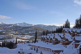
Big Sky is an unincorporated community and census-designated place (CDP) in Gallatin and Madison counties in southwestern Montana, United States. As of the 2020 census, it had a population of 3,591, up from 2,308 in 2010. It is 44 miles (71 km) by road southwest of Bozeman. The primary industry of the area is tourism.

Pompeys Pillar National Monument is a rock formation located in south central Montana, United States. Designated a national monument on January 17, 2001, and managed by the U.S. Bureau of Land Management in conjunction with The Friends of Pompeys Pillar, it consists of only 51 acres (21 ha), making it one of the smallest National Monuments in the U.S. The community of Pompeys Pillar lies just east of the monument.

Emigrant is an unincorporated community in Park County, Montana, United States. As of the 2010 census, the ZIP Code Tabulation Area (59027) for Emigrant had a population of 372. Emigrant is located in southern Montana, on the Yellowstone River, approximately 30 miles (48 km) north of Yellowstone National Park, and 20 miles (32 km) south of Livingston.
The Huntley Project is an irrigation project in southern Montana that was established by the United States Bureau of Reclamation in 1907. The district includes the towns of Huntley, Worden, Ballantine, and Pompeys Pillar.

Cooke City is an unincorporated community and census-designated place (CDP) in Park County, Montana, United States. As of the 2020 census, it had a population of 77. Prior to 2010, it was part of the Cooke City-Silver Gate CDP.

Miles City is a city in and the county seat of Custer County, Montana, United States. The population was 8,354 at the 2020 census.
Nibbe is a Census Designated Place located in Yellowstone County, Montana and shares a postal ZIP code with Pompey's Pillar (59064).


