Blaenau Ffestiniog is a town in Gwynedd,Wales. Once a slate mining centre in historic Merionethshire,it now relies much on tourists,drawn for instance to the Ffestiniog Railway and Llechwedd Slate Caverns. It reached a population of 12,000 at the peak development of the slate industry,but fell with the decline in demand for slate. The population of the community,including the nearby village Llan Ffestiniog,was 4,875 at the 2011 census:the fourth most populous in Gwynedd after Bangor,Caernarfon and Llandeiniolen. The population not including Llan is now only about 4,000.
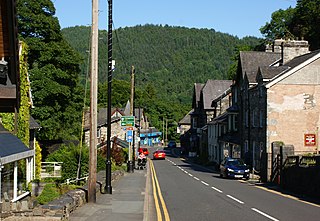
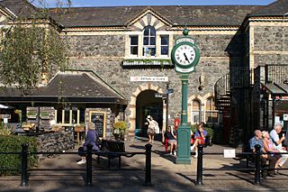
Betws-y-Coed is a village and community in the Conwy valley in Conwy County Borough,Wales,located in the historic county of Caernarfonshire,right on the boundary with Denbighshire,in the Gwydir Forest. It is now a very popular visitor destination in the Snowdonia National Park. The population of the community as of the 2021 census was 476,a decline on the previous census.
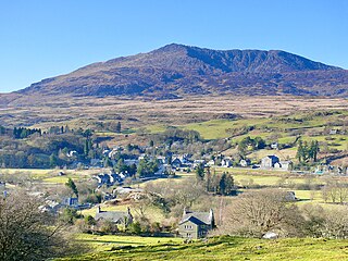
Dolwyddelan is a village and community in Conwy County Borough,Wales. The community occupies most of the valley of the Afon Lledr,and contains the settlements of Dolwyddelan,Pentre Bont,Blaenau Dolwyddelan,and Pont-y-Pant. It lies within Snowdonia,and the surrounding hills are part of the Moelwynion range. The population of the community was recorded as 454 in the 2021 census,and in the 2011 census the proportion of Welsh speakers was recorded as 50.8%.
The Conwy Valley line is a railway line in north-west Wales. It runs from Llandudno via Llandudno Junction to Blaenau Ffestiniog,and was originally part of the London and North Western Railway,being opened in stages to 1879. The primary purpose of the line was to carry slate from the Ffestiniog quarries to a specially built quay at Deganwy for export by sea. The line also provided goods facilities for the market town of Llanrwst,and via the extensive facilities at Betws-y-Coed on the London to Holyhead A5 turnpike road it served many isolated communities in Snowdonia and also the developing tourist industry. Although only a little over 27 miles (43 km) between Llandudno and Blaenau Ffestiniog,the journey takes over one hour,largely due to the sinuous and steeply graded nature of the route taken. Most of the stations along the line are treated as request stops.

Llandudno Junction is a station serving the village of Llandudno Junction on the North Wales Main Line between Crewe and Holyhead. The station is managed by Transport for Wales Rail,although Avanti West Coast services also stop there. It is a junction for trains to Llandudno and the Conwy Valley line.
Betws-y-coed railway station is on the Conwy Valley Line,which runs between Llandudno and Blaenau Ffestiniog. It is situated 15+1⁄2 miles (24.9 km) south of Llandudno Junction.

Llandudno railway station serves the seaside town of Llandudno in North Wales. It is the terminus of a 3 miles (4.8 km) long branch line from Llandudno Junction on the North Wales Coast Line,between Crewe and Holyhead. The station is managed by Transport for Wales Rail,who operate all trains serving it. Llandudno Victoria station,the lower terminus of the Great Orme Tramway,is a 15-minute walk from the main station.
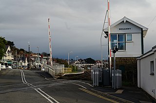
Deganwy railway station serves the town of Deganwy,Wales,and is the only intermediate station located on the Llandudno branch line from Llandudno Junction to Llandudno.

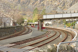
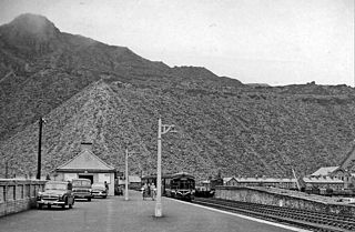
Blaenau Ffestiniog railway station serves the slate mining town of Blaenau Ffestiniog,Wales,and is the passenger terminus of the Conwy Valley Line from Llandudno Junction. Transport for Wales Rail operate through services to Llandudno Junction and Llandudno. The station is a joint station with the narrow gauge Ffestiniog Railway,which operates primarily tourist passenger services to Porthmadog throughout most of the year. A feature of the standard gauge service is the availability on trains and buses of the popular "Gwynedd Red Rover" day ticket.

Roman Bridge railway station is a request stop passenger station in the Lledr Valley,Wales,on the Conwy Valley Line from Llandudno Junction to Blaenau Ffestiniog,which is operated by Transport for Wales Rail.

Dolwyddelan railway station is a passenger station in the Lledr Valley,Wales,on the Conwy Valley Line from Llandudno Junction to Blaenau Ffestiniog,which is operated by Transport for Wales Rail. It is located at Pentre-Bont across the river a few hundred yards from the centre of Dolwyddelan. The station is unmanned.

North Llanrwst railway station is the only train passing station on the Conwy Valley line between Llandudno Junction and Blaenau Ffestiniog in Wales. The station has had several previous names,including Llanrwst and Trefriw,Llanrwst and Llanrwst North. This station is also a request stop.

The Afon Lledr is a river in north-west Wales and the second major tributary of the River Conwy. It is about 10 miles or 16 km long,and flows in a generally easterly direction.
The Lledr Valley is a valley in Snowdonia in north Wales. It runs from the top of the Crimea Pass,north of Blaenau Ffestiniog down to Betws-y-Coed.

Cwm Penmachno is a village at the head of Cwm Machno in North Wales.
Blaenau Festiniog Junction railway station was the Festiniog Railway (FR)'s third of eventually five passenger stations in Blaenau Ffestiniog,then in Merionethshire,now in Gwynedd,Wales.
Blaenau Ffestiniog North was the London and North Western Railway's (LNWR's) second passenger station in Blaenau Ffestiniog,then in Merionethshire,now in Gwynedd,Wales.

Rhiw-goch quarry was a slate quarry that was worked from the 1860s to 1908. It stands on the north side of the Afon Lledr,on the opposite side of the valley from Pont-y-Pant railway station.

Owen Gethin Jones,was a Welsh building contractor,quarry owner and prominent poet.