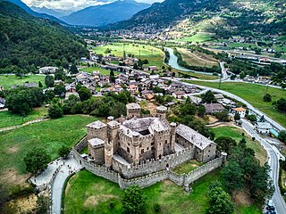
The Aosta Valley is a mountainous autonomous region in northwestern Italy. It is bordered by Auvergne-Rhône-Alpes, France, to the west, Valais, Switzerland, to the north, and by Piedmont, Italy, to the south and east. The regional capital is Aosta.

An arch bridge is a bridge with abutments at each end shaped as a curved arch. Arch bridges work by transferring the weight of the bridge and its loads partially into a horizontal thrust restrained by the abutments at either side. A viaduct may be made from a series of arches, although other more economical structures are typically used today.

Aosta is the principal city of the Aosta Valley, a bilingual region in the Italian Alps, 110 km (68 mi) north-northwest of Turin. It is situated near the Italian entrance of the Mont Blanc Tunnel, at the confluence of the Buthier and the Dora Baltea, and at the junction of the Great and Little St Bernard Pass routes.
The development of music in the Aosta Valley region of Italy reflects the multilingual make-up of the region including French, Valdôtain and recently Italian.

Cogne is a town and comune (municipality) in Aosta Valley, northern Italy, with 1369 inhabitants, as of 2017.

Pont-Saint-Martin ; Piedmontese: Pont San Martìn) is a town and comune in the Aosta Valley region of northwest Italy.

Saint-Martin-d'Ardèche is a commune in the department of Ardèche in Southern France.

The Trezzo sull'Adda Bridge or Trezzo Bridge was a medieval bridge at Trezzo sull'Adda in Lombardy, Italy, spanning the Adda river. Completed in 1377, the single-arch bridge held the record for the largest span for over four hundred years, until the beginnings of the Industrial Age, while it was not until the early 20th century that masonry bridges with larger openings were constructed.
Pont-Saint-Martin may refer to the following places:

The Puente de San Martín is a medieval bridge across the river Tagus in Toledo, Spain.

The Pont del Diable, also known as Sant Bartomeu Bridge, is a medieval bridge crossing the river Llobregat and straddling the municipalities of Martorell and Castellbisbal in Catalonia, Spain. The bridge is restricted to pedestrians.

The Pont sur la Laye or Pont roman de Mane is an old stone arch bridge across the stream Laye in the French Provence close to the town Mane.

The Roman Bridge at Saint-Thibéry was a Roman bridge on the Via Domitia in southern France. The partly surviving structure crossed the river Hérault in Saint-Thibéry, 17 km (11 mi) east of Béziers.

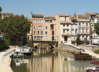
The Pont des Marchands is a historic bridge in Narbonne, southern France. It serves as a foundation for a row of houses and shops underneath which the Canal de la Robine runs through the old town. Its segmental arch has a span of ca. 15 m. In Roman times the structure featured as many as six arches.

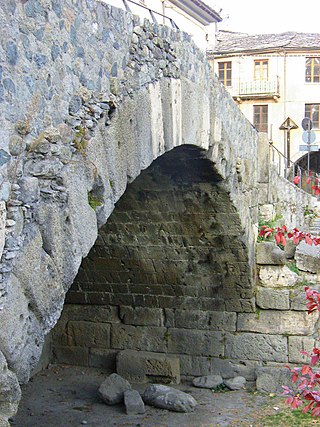
The Pont de Pierre, meaning "Stone Bridge", is a Roman bridge in the Italian city of Aosta in the Aosta Valley. The bridge crossed the Buthier about 600 m (2,000 ft) from the eastern exit of the Roman colony Augusta Praetoria; in later times the torrente changed its course, leaving the ancient bridge today without water.

The Pont d'Aël is a Roman aqueduct located in a village of the same name in the comune of Aymavilles in Aosta Valley, northern Italy. It was built in the year 3BC for irrigation purposes and supplying water for the newly founded colony of Augusta Praetoria, which is now known as Aosta. The water was directed through a neighbouring valley 66 m above the floor of the Aosta valley, through a sophisticated system. The aqueduct is 6 km long in total. In addition to its unusual position, the construction, which was originally thought to be a three-story structure, shows more unique features such as a control corridor below the water line, as well as explicit private funding. Today, the water channel of the aqueduct serves as a public walking trail.

The Bridge of Grand Arvou is an aqueduct-bridge in the frazione Porossan of Aosta, north-western Italy. It span the Rû Prévôt irrigation canal, and includes a large corridor covered by flagstones. Another aqueduct-bridge, the Petit Arvou, is located a few meters downstream.

The France–Italy border is 515 km long. It runs from the Alps in the north, a region in which it passes over Mont Blanc, down to the Mediterranean coast in the south. Three national parks are located along the border: Vanoise National Park and Mercantour National Park on the French side and Gran Paradiso National Park on the Italian side.

A segmental arch is a type of arch with a circular arc of less than 180 degrees. It is sometimes also called a scheme arch.


