
Durdle Door is a natural limestone arch on the Jurassic Coast near Lulworth in Dorset, England. It is owned by the Welds, a family who own 12,000 acres (50 km2) in Dorset in the name of the Lulworth Estate. It is open to the public.

Greensand or green sand is a sand or sandstone which has a greenish color. This term is specifically applied to shallow marine sediment that contains noticeable quantities of rounded greenish grains. These grains are called glauconies and consist of a mixture of mixed-layer clay minerals, such as smectite and glauconite mica. Greensand is also loosely applied to any glauconitic sediment.

Dorset is a county in South West England on the English Channel coast. Covering an area of 2,653 square kilometres (1,024 sq mi); it borders Devon to the west, Somerset to the north-west, Wiltshire to the north-east, and Hampshire to the east. The great variation in its landscape owes much to the underlying geology which includes an almost unbroken sequence of rocks from 200 Ma to 40 Ma and superficial deposits from 2 Ma to the present. In general the oldest rocks appear in the far west of the county, with the most recent (Eocene) in the far east. Jurassic rocks also underlie the Blackmore Vale and comprise much of the coastal cliff in the west and south of the county; and although younger Cretaceous rocks crown some of the highpoints in the west, they are mainly to be found in the centre and east of the county.
The Purbeck Group is an Upper Jurassic to Lower Cretaceous lithostratigraphic group in south-east England. The name is derived from the district known as the Isle of Purbeck in Dorset where the strata are exposed in the cliffs west of Swanage.
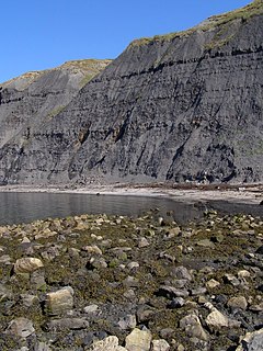
The Kimmeridge Clay is a sedimentary deposit of fossiliferous marine clay which is of Late Jurassic to lowermost Cretaceous age and occurs in southern and eastern England and in the North Sea. This rock formation is the major source rock for North Sea oil. The fossil fauna of the Kimmeridge Clay includes turtles, crocodiles, sauropods, plesiosaurs, pliosaurs and ichthyosaurs, as well as a number of invertebrate species.

William Joscelyn Arkell FGS, FRS was a British geologist and palaeontologist, regarded as the leading authority on the Jurassic Period during the middle part of the 20th century.

The Blue Lias is a geological formation in southern, eastern and western England and parts of South Wales, part of the Lias Group. The Blue Lias consists of a sequence of limestone and shale layers, laid down in latest Triassic and early Jurassic times, between 195 and 200 million years ago. The Blue Lias is famous for its fossils, especially ammonites.
Leslie Reginald Cox FRS was an English palaeontologist and malacologist.

The Inferior Oolite is a sequence of Jurassic age sedimentary rocks in Europe. It was deposited during the Middle Jurassic. The Inferior Oolite Group as more recently defined is a Jurassic lithostratigraphic group in southern and eastern England. It has been variously known in the past as the Under Oolite, the Inferior Oolite, the Inferior Oolite Series and the Redbourne Group.
The Forest Marble is a geological formation in England. Part of the Great Oolite Group, it dates to back to the late Bathonian stage of the Middle Jurassic.

The Fernie Formation is a stratigraphic unit of Jurassic age. It is present in the western part of the Western Canada Sedimentary Basin in western Alberta and northeastern British Columbia. It takes its name from the town of Fernie, British Columbia, and was first defined by W.W. Leach in 1914.

Kimmeridge Bay is a bay on the Isle of Purbeck, a peninsula on the English Channel coast in Dorset, England, close to and southeast of the village of Kimmeridge, on the Smedmore Estate. The area is renowned for its fossils, with The Etches Collection in the village of Kimmeridge displaying fossils found by Steve Etches in the area over a 30-year period. It is a popular place to access the coast for tourists. To the east are the Kimmeridge Ledges, where fossils can be found in the flat clay beds.

The Lower Greensand Group is a geological unit, which forms part of the underlying geological structure of southeast England. South of London in the counties of West Sussex, East Sussex, Surrey and Kent, which together form the wider Weald, the Lower Greensand can usually be subdivided to formational levels with varying properties into the Atherfield Clay Formation, the Hythe Formation, the Sandgate Formation, and the Folkestone Formation. In areas north and west of London, including Cambridgeshire, Bedfordshire and Buckinghamshire the Lower Greensand is referred to as the Woburn Sands Formation. In Oxfordshire it is known as the Faringdon Sand. In North Wiltshire as the Calne Sands Formation and in parts of Wiltshire, Oxfordshire and Buckinghamshire as the Seend Ironstone Formation.

The Northampton Sand Formation, sometimes called the Northamptonshire Sand, is a Middle Jurassic geological formation which is placed within the Inferior Oolite Group. It was formerly worked extensively in Northamptonshire for its ironstone.

The geology of East Sussex is defined by the Weald–Artois anticline, a 60 kilometres (37 mi) wide and 100 kilometres (62 mi) long fold within which caused the arching up of the chalk into a broad dome within the middle Miocene, which has subsequently been eroded to reveal a lower Cretaceous to Upper Jurassic stratigraphy. East Sussex is best known geologically for the identification of the first dinosaur by Gideon Mantell, near Cuckfield, to the famous hoax of the Piltdown man near Uckfield.

Pleurosternon is an extinct genus of cryptodire turtle from the late Jurassic period to the early Cretaceous period. Its type species, P. bullocki was described by the paleontologist Richard Owen in 1853. Since then, and throughout the late 19th century, many fossil turtles were incorrectly assigned to this genus.

The Portland Group is a Late Jurassic (Tithonian) lithostratigraphic group in South East England. The name is derived from the Isle of Portland in Dorset where the strata are exposed and have been extensively worked. Rocks of this age have in the past been called the Portlandian stage by geologists, which corresponds with the late Tithonian stage of the internationally used geological timescale.

The Corallian Group or Corallian Limestone is a geologic group in England. It is predominantly a coralliferous sedimentary rock, laid down in the Oxfordian stage of the Jurassic. It is a hard variety of "coral rag". Building stones from this geological structure tend to be irregular in shape. It is often found close to seams of Portland Limestone. It is a younger limestone than its near-neighbour, the Oolitic, as found in the Cotswolds, in Gloucestershire. It is laterally equivalent to and interfingers with units of the Ancholme Group.
The Worcester Basin or Worcester Graben is a sedimentary basin in central England, filled with mainly Permian and Triassic rocks. It trends roughly north-south and lies between the East Malverns Fault in the west and the Inkberrow Fault in the east. It forms part of a series of Permo-Triassic basins that stretch north-south across England, including the Cheshire Basin and the East Irish Sea Basin. These basins resulted from a regional rifting event that affected parts of North-West Europe, eastern North America and East Greenland.

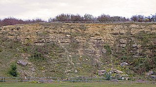
The Bridport Sand Formation is a formation of Toarcian age found in the Worcester and Wessex Basins of central and southern England. It forms one of the reservoir units in the Wytch Farm oilfield in Dorset. The sandstone is very-fine grained to fine-grained and contains regular narrow bands that are calcite-cemented and more resistant to weathering, giving it a characteristic banded appearance at outcrop, such as in the cliffs between Bridport and Burton Bradstock in Dorset. It is named for Bridport and has previously been known as the Midford Sand(s), Cotteswold Sands, Yeovil Sands and Upper Lias Sand(s). It forms a locally important aquifer, particularly around Yeovil.