Pre-Columbian Bolivia

Last updated
Gate of the Sun in Tiwanaku Zonnepoort tiwanaku.jpg
Gate of the Sun in Tiwanaku
Quinoa plants Quinua.JPG
Quinoa plants
Tiwanaku empire at its largest territorial extent, AD 950 Map of Wari and Tiawaku.svg
Tiwanaku empire at its largest territorial extent, AD 950

Pre-Columbian Bolivia covers the historical period between 10,000 BCE, when the Upper Andes region was first populated and 1532, when Spanish conquistadors invaded Inca empire. The Andes region of Pre-Columbian South America was dominated by the Tiwanaku civilization until about 1200, when the regional kingdoms of the Aymara emerged as the most powerful of the ethnic groups living in the densely populated region surrounding Lake Titicaca. Power struggles continued until 1450, when the Incas incorporated upper Bolivia into their growing empire. Based in present-day Peru, the Incas instituted agricultural and mining practices that rivaled those put in place many years later by European conquerors. They also established a strong military force, and centralized political power. Despite their best efforts however, the Incas never completely controlled the nomadic tribes of the Bolivian lowlands, nor did they fully assimilate the Aymara kingdoms into their society. These internal divisions doomed the Inca Empire when European conquerors arrived. [1]

Contents

Earliest cultures

Various cultures of indigenous peoples in Bolivia developed in the high altitude settings of altiplano, where they coped with low oxygen levels, poor soils and extreme weather patterns. The more temperate and fertile lowlands were sparsely inhabited by hunter-gatherer societies. Much of the pre-Columbian population was concentrated in the altiplano valleys of Cochabamba and Chuquisaca.

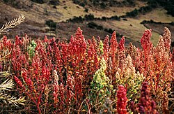
The potato was domesticated near lake Titicaca between 8000 and 5000 BC, quinoa some 3000–4000 years ago, and production of copper began in 2000 BC. Llama, alpaca and vicuña were also domesticated and used for transport, food and clothing.

The site of Jisk'a Iru Muqu was first investigated by modern researchers in 1994. A necklace consisting of nine gold beads was found in an excavated grave located next to a Terminal Archaic pit house. Charcoal recovered from the burial dates the gold beads to 2155-1936 cal BC [2]

The earliest known cultures in Bolivia were the Wankarani culture, and the Chiripa culture. The oldest Wankarani sites are dated from 1800 BC onwards. [3] Wankarani culture arose in the area of Oruro Department near Lake Poopo.

Pre-Columbian cultures in Bolivia

Tiwanaku empire

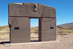
Situated in Western Bolivia, the Tiwanaku empires' capital city also named Tiwanaku has been dated to as early as 1200 BC, where it originated as a small agricultural village. [4] In around 400 AD the Tiwanaku empire began its expansion, appropriating the Yungas and establishing contacts with other cultures in Peru, Bolivia and Chile. By 600 AD it became an important regional power in the southern Andes. [5] Tiwanako then underwent a dramatic transformation between 600 and 700 AD that established new monumental standards in civic architecture for the region and greatly increased the resident population. [6]

The Tiwanaku empire is believed to have absorbed cultures rather than eradicating them. Archaeologists have also seen a dramatic adoption of Tiwanaku ceramics amongst the cultures who became part of the empire. Tiwanaku strengthened its power over its domain through the trade implemented between all of the cities within the empire. [5] The elites thereby gained status by collecting surplus food stocks from all the regions under their influence, and then redistributing it back to the people where needed. This made maintaining large llama herds essential, for carrying goods back and forth between the center of the empire and the periphery.

In about 950 AD a dramatic shift in the regions' climate occurred. [7] A significant drop in annual precipitation in the Titicaca Basin followed as a result, and many cities further away from Lake Titicaca with less access to water sources began to produce less crops, and diminishing surplus food stock to provide to the elites as a result. The immediate area surrounding the capital city and the lake eventually became the last source of substantial agricultural food production for the empire, due to the resiliency of the raised fields to efficiently produce food crops, but in the end even the intelligent design of the fields was no match for the changing climate. The Tiwanaku empire is believed to have dissolved around year 1000 AD when substantial food production ceased, and with it, the main source of power for the ruling elites dried up. The land was not inhabited again for many years after that. [7]

Aymara kingdoms

Chullpas Grabstatten in Sillustani .jpg
Chullpas

Between 1100 and 1460 AD the Aymaras developed a number of kingdoms in the region surrounding lake Titicaca, of which the Lupaca, Colla and Cana kingdoms were the largest. These were located farther inland in fortified towns (pucara), and chullpa burial and ceremonial towers still remain. Although the Aymaras were based, and prospered in, the harsh altiplano conditions they also controlled lands on eastern slopes of the Andes that were more suited for food production – colonies were also established in lowland temperate and semitropical areas in order to grow adequate food stocks to sustain their populations. This type of society organization has been called the vertical archipelago.

Aymara society was organized by ayllus, or kinship groups. [8] An Ayllu was divided into two strata – upper (hanansaya) and lower (urinsaya). The Aymaras also controlled and dominated the Uru and Puquina people, who had lived in the Andean region before the Aymaras, and by the 12th century they were reduced to the status of oppressed, landless workers subservient to the Aymaras. Aymara dominance in the region was however eventually challenged by the growing state of the Quechuas from Cuzco, who finally conquered them between 1460 and 1500 AD.

Inca empire

Flag of Qullasuyu

The Incas conquered much of what is now western Bolivia under their ninth emperor Pachacuti Inca Yupanqui, whose reign lasted from 1438 to 1471 AD. Pachacuti Yupanqui was then succeeded by his son Topa Inca Yupanqui whose reign lasted from 1471 to 1493 AD. Western Bolivia became one of the four Incan territories within its empire known as Qullasuyu, with an estimated one million inhabitants. [9]

The highest official of Qullasuyu ruled on behalf of the "Inca" (the emperor) and supervised a group of provincial governors, who in turn controlled the members of the Aymara nobility. Under a draft system called the Mit'a, the Incas forced the peoples under their domination to work in mines, on construction projects, or to serve in the armies. Surprisingly these draftees were compensated fully for their labor. [8]

Despite their policy of extreme centralization, the Incas did not fundamentally change the organization of the Aymara kingdoms, and these kingdoms remained relatively autonomous. Many local chiefs kept much of their power, and in general their rule was supported by Incan authority. The Aymara under these conditions were able to retain their culture, local religious practices, and their language. The regional nobility, although forced to send their children to Cuzco for education, also continued to hold private property. Moreover, the Aymara practice of developing new colonies in the eastern valleys and along the coast was tolerated under Incan rule. [8]

In 1470 AD several Aymara kingdoms began rebelling against the Incas. The Incas however completely defeated two Aymara states and pacified the region overall by sending mitimas, Quechua-speaking colonists, to Aymara territories particularly to the southern valleys and to the more central valley regions where Cochabamba and Sucre were later founded. By the beginning of the 16th century the Incas had fully reestablished their rule. [8]

Despite their renewed dominance, the Incas failed however to conquer the nomadic tribes in the eastern Bolivian lowlands. The remains of Incan fortresses here reveal evidence of this failure and suggest that Incas could subdue only those cultures based on agricultural activities. As a result of their resistance, the nomadic tribes in the eastern lowlands occupying two-thirds of Bolivia preserved their way of life to a great extent, even after the Spanish conquest. [8] The independence and success of the Moxo people for instance was shown by their construction of elevated causeways to manage the regular floods in the region and to serve their population.

See also

Related Research Articles

<span class="mw-page-title-main">Inca Empire</span> 1438–1533 empire in South America

The Inca Empire, called Tawantinsuyu by its subjects, was the largest empire in pre-Columbian America. The administrative, political, and military center of the empire was in the city of Cusco. The Inca civilization rose from the Peruvian highlands sometime in the early 13th century. The Spanish began the conquest of the Inca Empire in 1532 and by 1572, the last Inca state was fully conquered.

<span class="mw-page-title-main">Tiwanaku</span> Archaeological site in Bolivia

Tiwanaku is a Pre-Columbian archaeological site in western Bolivia, near Lake Titicaca, about 70 kilometers from La Paz, and it is one of the largest sites in South America. Surface remains currently cover around 4 square kilometers and include decorated ceramics, monumental structures, and megalithic blocks. The site's population probably peaked around AD 800 with 10,000 to 20,000 people.

<span class="mw-page-title-main">Aymara people</span> Indigenous people in the Andes and Altiplano regions of South America

The Aymara or Aimara, people are an indigenous people in the Andes and Altiplano regions of South America; about 2.3 million live in northwest Argentina, Bolivia, Chile, and Peru. Their ancestors lived in the region for many centuries before becoming a subject people of the Inca in the late 15th or early 16th century, and later of the Spanish in the 16th century. With the Spanish-American wars of independence (1810–1825), the Aymaras became subjects of the new nations of Bolivia and Peru. After the War of the Pacific (1879–1883), Chile annexed territory with the Aymara population.

<span class="mw-page-title-main">Department of Puno</span> Departments of Peru

Puno is a department and region in southeastern Peru. It is the fifth largest department in Peru, after Cuzco, Madre de Dios, Ucayali, and Loreto. It is bordered by Bolivia on the east, the departments of Madre de Dios on the north, Cusco and Arequipa on the west, Moquegua on the southwest, and Tacna on the south. Its capital is the city of Puno, which is located on Lake Titicaca in the geographical region known as the Altiplano or high sierra.

<span class="mw-page-title-main">Altiplano</span> Large plateau in west-central South America

The Altiplano, Collao or Andean Plateau, in west-central South America, is the most extensive high plateau on Earth outside Tibet. The plateau is located at the latitude of the widest part of the north–south-trending Andes. The bulk of the Altiplano lies in Bolivia, but its northern parts lie in Peru, and its southwestern fringes lie in Chile.

<span class="mw-page-title-main">Chachapoya culture</span> Andean culture

The Chachapoyas, also called the "Warriors of the Clouds", was a culture of the Andes living in the cloud forests of the southern part of the Department of Amazonas of present-day Peru. The Inca Empire conquered their civilization shortly before the Spanish conquest in the 16th century. At the time of the arrival of the conquistadors, the Chachapoyas were one of the many nations ruled by the Incas, although their incorporation had been difficult due to their constant resistance to Inca troops.

<span class="mw-page-title-main">Isla del Sol</span> Island in the southern part of Lake Titicaca

Isla del Sol is an island in the southern part of Lake Titicaca. It is part of Bolivia, and specifically part of the La Paz Department. Geographically, the terrain is harsh; it is a rocky, hilly island with many eucalyptus trees. There are no motor vehicles or paved roads on the island. The main economic activity of the approximately 800 families on the island is farming, with fishing and tourism augmenting the subsistence economy. Of the several villages, Yumani and Challapampa are the largest.

<span class="mw-page-title-main">Sillustani</span> Archaeological site in Peru

Sillustani is a pre-Inca cemetery on the shores of Lake Umayo near Puno in Peru. The tombs, which are built above ground in tower-like structures called chullpas, are the vestiges of the Qulla people, who are Aymara conquered by the Inca Empire in the 15th century.

<span class="mw-page-title-main">Gate of the Sun</span> Bolivian monolith

The Gate of the Sun, also known as the Gateway of the Sun, is a monolith carved in the form of an arch or gateway at the site of Tiahuanaco by the Tiwanaku culture, an Andean civilization of Bolivia that thrived around Lake Titicaca in the Andes of western South America around 500-950 AD.

Waru Waru is an Aymara term for the agricultural technique developed by pre-Hispanic people in the Andes region of South America from Ecuador to Bolivia; this regional agricultural technique is also referred to as camellones in Spanish. Functionally similar agricultural techniques have been developed in other parts of the world, all of which fall under the broad category of raised field agriculture.

The history of Bolivia involves thousands of years of human habitation.

<span class="mw-page-title-main">Lupaca</span>

The Lupaca, Lupaka, or Lupaqa people were one of the divisions of the ancestral Aymaras. The Lupaca lived for many centuries near Lake Titicaca in Peru and their lands possibly extended into Bolivia. The Lupacas and other Aymara peoples formed powerful kingdoms after the collapse of the Tiwanaku Empire in the 11th century. In the mid 15th century they were conquered by the Inca Empire and in the 1530s came under the control of the Spanish Empire.

<span class="mw-page-title-main">Andean civilizations</span> Civilizations of South Americas Andes Mountains

The Andean civilizations were South American complex societies of many indigenous people. They stretched down the spine of the Andes for 4,000 km (2,500 mi) from southern Colombia, to Ecuador and Peru, including the deserts of coastal Peru, to north Chile and northwest Argentina. Archaeologists believe that Andean civilizations first developed on the narrow coastal plain of the Pacific Ocean. The Caral or Norte Chico civilization of coastal Peru is the oldest known civilization in the Americas, dating back to 3500 BCE. Andean civilization is one of the six "pristine" civilizations of the world, created independently and without influence by other civilizations.

<span class="mw-page-title-main">History of Andean South America</span>

The history of human habitation in the Andean region of South America stretches from circa 15,000 BCE to the present day. Stretching for 7,000 km (4,300 mi) long, the region encompasses mountainous, tropical and desert environments. This colonisation and habitation of the region has been affected by its unique geography and climate, leading to the development of unique cultural and socn.

<span class="mw-page-title-main">Pukara culture</span> South American archaeological culture

The Pucará culture was an archaeological culture which developed in Qullaw, along the north-western shore of Lake Titicaca. It was characterized by a hierarchy of sites made up several smaller centers and villages scattered throughout the northern basin of the Titicaca, ruled from its nucleus - the town of Pukara with an approximate extension of 6 square kilometers, constituted the first properly urban settlement in the Titicaca basin. Its sphere of influence reached as far north as the Cuzco Valley and as far south as Tiahuanaco. The culture had two phases of development within the Formative Period: the Middle Formative, and Late Formative.

<span class="mw-page-title-main">Andean preceramic</span>

The Andean preceramic refers to the early period of human occupation in the Andean area of South America that preceded the introduction of ceramics. This period is also called pre-ceramic or aceramic.

<span class="mw-page-title-main">Tiwanaku Empire</span> Pre-Columbian polity in Western Bolivia

The Tiwanaku Polity was a Pre-Columbian polity in western Bolivia based in the southern Lake Titicaca Basin. Tiwanaku was one of the most significant Andean civilizations. Its influence extended into present-day Peru and Chile and lasted from around 600 to 1000 AD. Its capital was the monumental city of Tiwanaku, located at the center of the polity's core area in the southern Lake Titicaca Basin. This area has clear evidence for large-scale agricultural production on raised fields that probably supported the urban population of the capital. Researchers debate whether these fields were administered by a bureaucratic state (top-down) or through a federation of communities with local autonomy. Tiwanaku was once thought to be an expansive military empire, based mostly on comparisons to the later Inca Empire. However, recent research suggests that labelling Tiwanaku as an empire or even different varieties of a state may even be misleading. Tiwanaku is missing a number of features used to define these types of polities: there is no defensive architecture at any Tiwanaku site or changes in weapon technology, there are no princely burials or other evidence of a ruling dynasty or a formal social hierarchy, no evidence of state-maintained roads or outposts, and no markets.

<span class="mw-page-title-main">Wankarani culture</span>

The Wankarani culture was a formative stage culture that existed from approximately 1500 BCE to 400 CE on the altiplano highlands of Bolivia's Oruro Department to the north and northeast of Lake Poopo. It is the earliest known sedentary culture in Bolivia, as after circa 1200 BCE camelid hunters of the altiplano became camelid herders and sedentary lifestyle developed. The Wankarani culture was little researched before 1970, when Carlos Ponce Sanginés defined all the mound sites in the area as belonging to one culture that predated Tiwanaku and was contemporary with the Chiripa culture.

<span class="mw-page-title-main">Colla Kingdom</span>

The Colla, Qolla or Qulla Kingdom was established in the northwestern basin of the Titicaca, one of the Aymara kingdoms that occupied part of the Collao plateau after the fall of Tiwanaku. In the mid-15th century the Collas possessed a vast territory, one of the largest of the Aymara kingdoms, which at the time the 9th Sapan Inka Pachakutiq Yupanqui Qhapaq the Intipchurin, conquered along with other political entities in the region.

<span class="mw-page-title-main">Aymara kingdoms</span>

The Aymara kingdoms, Aymara lordships or lake kingdoms were a group of native polities that flourished towards the Late Intermediate Period, after the fall of the Tiwanaku Empire, whose societies were geographically located in the Qullaw. They were developed between 1150 and 1477, before the kingdoms disappeared due to the military conquest of the Inca Empire. But the current Aymara population is estimated at two million located in the countries of Bolivia, Peru, Chile and Argentina. They used the Aymara and Puquina languages.

References

  1. Country Profile: Bolivia ( PDF ). Library of Congress Federal Research Division (January 2006). PD-icon.svg This article incorporates text from this source, which is in the public domain .
  2. Aldenderfer, Mark; Craig, Nathan M.; Speakman, Robert J.; Popelka-Filcoff, Rachel (2008), "Four-thousand-year-old gold artifacts from the Lake Titicaca basin, southern Peru", Proceedings of the National Academy of Sciences, 105 (13): 5002–5, Bibcode:2008PNAS..105.5002A, doi: 10.1073/pnas.0710937105 , JSTOR   25461542, PMC   2278197 , PMID   18378903
  3. Jason (Jake) R. Fox, Time and Process in an Early Village Settlement System on the Bolivian Southern Altiplano. Archived 2016-03-04 at the Wayback Machine PhD Thesis 2007
  4. Fagan, Brian M. 'The Seventy Great Mysteries of the Ancient World: Unlocking the Secrets of Past Civilizations'. New York: Thames & Hudson, 2001.
  5. 1 2 McAndrews, Timothy L. et al. "Regional Settlement Patterns in the Tiwanaku Valley of Bolivia". Journal of Field Archaeology 24 (1997): 67–83.
  6. Isbell, William H. 'Wari and Tiwanaku: International Identities in the Central Andean Middle Horizon'. 731–751.
  7. 1 2 Kolata, Alan L. 'The Tiwankau: Portrait of an Andean Civilization'. Blackwell Publishers, Cambridge, 1993.
  8. 1 2 3 4 5 Hudson, Rex A.; Hanratty, Dennis Michael (1991). "Historical Setting". Bolivia: A country study (Third ed.). Library of Congress Federal Research Division. pp. 6–7. LCCN   90026427.PD-icon.svg This article incorporates text from this source, which is in the public domain .
  9. A Concise History of Bolivia