The Inca Empire, officially known as the Realm of the Four Parts, was the largest empire in pre-Columbian America. The administrative, political, and military center of the empire was in the city of Cusco. The Inca civilization rose from the Peruvian highlands sometime in the early 13th century. The Spanish began the conquest of the Inca Empire in 1532, and by 1572 the last Inca state was fully conquered.
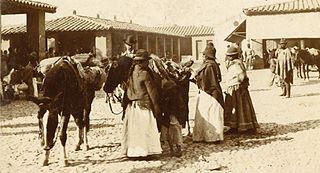
The Aymara or Aimara, people are an indigenous people in the Andes and Altiplano regions of South America. Approximately 2.3 million Aymara live in northwest Argentina, Bolivia, Chile, and Peru. The ancestors of the Aymara lived in the region for many centuries before becoming a subject people of the Inca Empire in the late 15th or early 16th century, and later of the Spanish in the 16th century. With the Spanish American wars of independence (1810–1825), the Aymaras became subjects of the new nations of Bolivia and Peru. After the War of the Pacific (1879–1883), Chile annexed territory with the Aymara population.

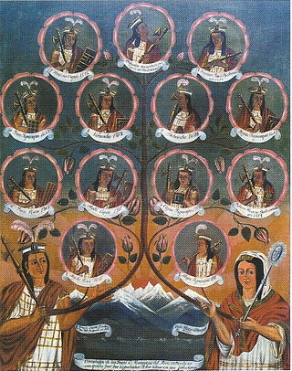
Pachacuti Inca Yupanqui, also called Pachacútec, was the ninth Sapa Inca of the Chiefdom of Cusco, which he transformed into the Inca Empire. Most archaeologists now believe that the famous Inca site of Machu Picchu was built as an estate for Pachacuti.

Huayna Capac was the third Sapa Inca of Tawantinsuyu, the Inca Empire. He was the son of and successor to Túpac Inca Yupanqui., the sixth Sapa Inca of the Hanan dynasty, and eleventh of the Inca civilization. He was born in Tumipampa and tutored to become Sapa Inca from a young age.

Puno is a department and region in southeastern Peru. It is the fifth largest department in Peru, after Cuzco, Madre de Dios, Ucayali, and Loreto. It is bordered by Bolivia on the east, the departments of Madre de Dios on the north, Cusco and Arequipa on the west, Moquegua on the southwest, and Tacna on the south. Its capital is the city of Puno, which is located on Lake Titicaca in the geographical region known as the Altiplano or high sierra.
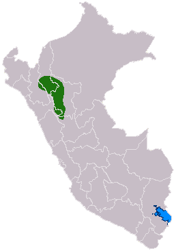
The Chachapoyas, also called the "Warriors of the Clouds", was a culture of the Andes living in the cloud forests of the southern part of the Department of Amazonas of present-day Peru. The Inca Empire conquered their civilization shortly before the Spanish conquest in the 16th century. At the time of the arrival of the conquistadors, the Chachapoyas were one of the many nations ruled by the Incas, although their incorporation had been difficult due to their constant resistance to Inca troops.

A panaca or panaqa, or panaka was a family clan of the Sapa Inca, the kuraka or emperor of the Inca Empire. The panacas were formed by the descendants of a Sapa Inca or his wife. The basic social institution of the Incas is the ayllu. An ayllu is a group of families that descended from a common ancestor, united by culture and religion, in addition to the agricultural work, livestock and fishing of the same territory. The ayllu concept transcended into nobility, so that the royal kinship could establish a lineage, called panaca or royal house.

Sillustani is a pre-Inca cemetery on the shores of Lake Umayo near Puno in Peru. The tombs, which are built above ground in tower-like structures called chullpas, are the vestiges of the Qulla people, most likely a Puquina-speaking people, conquered by the Inca Empire in the 15th century.
The Incas were most notable for establishing the Inca Empire which was centered in modern-day South America in Peru and Chile. It was about 4,000 kilometres (2,500 mi) from the northern to southern tip. The Inca Empire lasted from 1438 to 1533. It was the largest Empire in America throughout the Pre-Columbian era. The Inca state was known as the Kingdom of Cuzco before 1438. Over the course of the Inca Empire, the Inca used conquest and peaceful assimilation to incorporate the territory of modern-day Peru, followed by a large portion of western South America, into their empire, centered on the Andean mountain range. However, shortly after the Inca Civil War, the last Sapa Inca (emperor) of the Inca Empire was captured and killed on the orders of the conquistador Francisco Pizarro, marking the beginning of Spanish rule. The remnants of the empire retreated to the remote jungles of Vilcabamba and established the small Neo-Inca State, which was conquered by the Spanish in 1572.

Francisco Álvarez de Toledo, also known as The Viceroyal Solon, was an aristocrat and soldier of the Kingdom of Spain and the fifth Viceroy of Peru. Often regarded as the "best of Peru's viceroys", he is as often denounced for the negative impact his administration had on the Indigenous peoples of Peru.

The Kingdom of Cusco, also called the Cusco confederation, was a small kingdom based in the Andean city of Cusco that began as a small city-state founded by the Incas around the start of 13th century. In time, through warfare or peaceful assimilation, it began to grow into the Inca Empire (1438–1533).

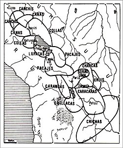
The Lupaca, Lupaka, or Lupaqa people were one of the divisions of the ancestral Aymaras. The Lupaca lived for many centuries near Lake Titicaca in Peru and their lands possibly extended into Bolivia. The Lupacas and other Aymara peoples formed powerful kingdoms after the collapse of the Tiwanaku Empire in the 11th century. In the mid 15th century they were conquered by the Inca Empire and in the 1530s came under the control of the Spanish Empire.

The Andean civilizations were South American complex societies of many indigenous people. They stretched down the spine of the Andes for 4,000 km from southern Colombia, to Ecuador and Peru, including the deserts of coastal Peru, to north Chile and northwest Argentina. Archaeologists believe that Andean civilizations first developed on the narrow coastal plain of the Pacific Ocean. The Caral or Norte Chico civilization of coastal Peru is the oldest known civilization in the Americas, dating back to 3500 BCE. Andean civilizations are one of at least five civilizations in the world deemed by scholars to be "pristine." The concept of a "pristine" civilization refers to a civilization that has developed independently of external influences and is not a derivative of other civilizations.

Andean Baroque is an artistic movement that appeared in colonial Peru between 1680 and 1780. It is located geographically between Arequipa and Lake Titicaca in what is now Peru, where rules over the highlands and spreads over the entire altiplano. From the Portuguese word barrueco meaning impure, mottled, flamboyant, daring, the most striking example of Andean Baroque art is in religious architecture, where criollo and indigenous craftsmen together gave it a unique character, as happened in the New Spanish Baroque.

The history of human habitation in the Andean region of South America stretches from circa 15,000 BCE to the present day. Stretching for 7,000 km (4,300 mi) long, the region encompasses mountainous, tropical and desert environments. This colonisation and habitation of the region has been affected by its unique geography and climate, leading to the development of unique cultural and societal organisations.
A pukara is a pre-Hispanic central Andean fortress.

Pre-Columbian Bolivia covers the historical period between 10,000 BCE, when the Upper Andes region was first populated and 1532, when Spanish conquistadors invaded Inca empire. The Andes region of Pre-Columbian South America was dominated by the Tiwanaku civilization until about 1200, when the regional kingdoms of the Aymara emerged as the most powerful of the ethnic groups living in the densely populated region surrounding Lake Titicaca. Power struggles continued until 1450, when the Incas incorporated upper Bolivia into their growing empire. Based in present-day Peru, the Incas instituted agricultural and mining practices that rivaled those put in place many years later by European conquerors. They also established a strong military force, and centralized political power. Despite their best efforts however, the Incas never completely controlled the nomadic tribes of the Bolivian lowlands, nor did they fully assimilate the Aymara kingdoms into their society. These internal divisions doomed the Inca Empire when European conquerors arrived.

The history of Cusco (Peru), the historical capital of the Incas.
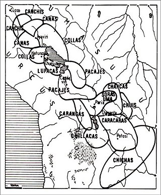
The Colla, Qolla or Qulla Kingdom was established in the northwestern basin of the Titicaca, one of the Aymara kingdoms that occupied part of the Collao plateau after the fall of Tiwanaku. In the mid-15th century the Collas possessed a vast territory, one of the largest of the Aymara kingdoms, which at the time the 9th Sapan Inka Pachakutiq Yupanqui Qhapaq the Intipchurin, conquered along with other political entities in the region.